

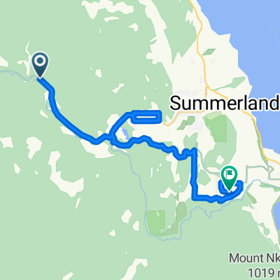
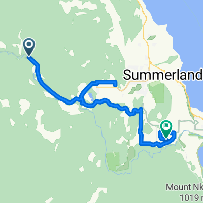
KVR - Glenfir - Penticton - OK Falls
Eine Fahrradroute, die in Summerland, British Columbia, Kanada beginnt.
Übersicht
Über diese Route
- -:--
- Dauer
- 43,5 km
- Distanz
- 143 m
- Aufstieg
- 607 m
- Abstieg
- ---
- Ø-Tempo
- ---
- Max. Höhe

Routenqualität
Wegtypen und Untergründe entlang der Route
Wegtypen
Radweg
33,9 km
(78 %)
Forst- / Feldweg
4,3 km
(10 %)
Untergründe
Befestigt
10,4 km
(24 %)
Unbefestigt
30 km
(69 %)
Schotter
27,4 km
(63 %)
Befestigt (undefiniert)
5,7 km
(13 %)
Highlights der Route
POIs entlang der Route
Interessanter Ort nach 0 km
Drop off point - Glenfir parking lot - option of riding up the trail to Rock Ovens and Old Growth Ponderosa Pines - Trail is a bit rocky and can be tough to ride.
Interessanter Ort nach 4,3 km
Little Tunnel - Great picture taking spot!
Interessanter Ort nach 4,9 km
If you look down the hill here, you should see several old rusted cans. These are old blasting powder cans from the original construction of the tunnel.
Interessanter Ort nach 9,4 km
Just off the trail, you can see Naramata Falls here. A major workers camp during the original construction was just up the hill. The creek used to be called Camp Creek
Interessanter Ort nach 10,3 km
Site of the old Arawana station..foundations of old water tower have been turned into a picnic shelter
Interessanter Ort nach 15,2 km
You have the option here of staying on the trail or taking Riddle Road to catch a few wineries before you get back on the trail at Poplar Grove
Interessanter Ort nach 16 km
If you like cheese, you might want to visit Poplar Grove - great camembert and blue cheese here. Google has it in the wrong spot.
Interessanter Ort nach 16,4 km
Fun place to stop for a snack or an ice cream cone. If you choose to go to D'Angelo, you can either get off the trail at Davenport or Lochore.
Interessanter Ort nach 16,5 km
D'Angelo Estate Winery - there is a food truck here with great sandwiches if you want lunch. You can also play bocce. The wines are pretty good too! (By the way, don't follow Google's directions to the winery..they have it in the wrong place)
Interessanter Ort nach 17,5 km
If you wish, take the road up into the cemetery and you can visit Andrew McCulloch's gravesite. McCulloch was the chief engineer of the KVR. Go to the first gate into the cemetery and look along side the road for a yellow fire hydrant. Look two or three rows directly back from the hydrant and you should find the grave.
Interessanter Ort nach 19,4 km
The KVR Trail continues partway through Penticton if you continue across the road but end rather abruptly in the middle of the City. We suggest riding down Vancouver and getting on the Channel trail instead. Turn right here.
Interessanter Ort nach 20,2 km
You may want to check out the Japanese Garden while you're here.
Interessanter Ort nach 21 km
There is a multi use trail you can get on here.
Interessanter Ort nach 22,5 km
Cross over the channel here to get on the Channel trail, which will take you right through Penticton.
Interessanter Ort nach 23,3 km
Take the trail under the highway here.
Interessanter Ort nach 28,6 km
You'll leave the Channel Trail here for a bit and will have to ride on Skaha Lake Road. You're going to go into Wright's Beach Camp where the trail begins. This is a busy road, so you might want to turn into Barefoot Beach Resort and take the pedestrian tunnel under the road to the other side. Walk your bikes through here!
Interessanter Ort nach 29,9 km
You should be able to see the start of the trail here.
Interessanter Ort nach 36,8 km
Trail follows Alder Avenue for a ways.
Interessanter Ort nach 37,5 km
This is the remains of the Kaleden Hotel - which opened for a brief time before World War I but closed during the war and never reopened.
Interessanter Ort nach 38 km
KVR Trail follows Ponderosa Avenue for a short way here. You get back on the trail at the Ponderosa Point Resort
Interessanter Ort nach 42,1 km
Take the trail to your left through the little park. Turn right onto Railway Line, then left on 8th and right on Cedar. There will be a crosswalk across the highway.
Interessanter Ort nach 43,4 km
Pick up stop - Tickleberries - Great ice cream and sweets! There are picnic tables near the creek.
Weiter mit Bikemap
Diese Radroute verwenden, bearbeiten oder herunterladen
Du möchtest KVR - Glenfir - Penticton - OK Falls fahren oder sie für deine eigene Reise anpassen? Folgendes kannst du mit dieser Bikemap-Route machen:
Gratis Funktionen
- Speichere diese Route als Favorit oder in einer Sammlung
- Kopiere & plane deine eigene Version dieser Route
- Synchronisiere deine Route mit Garmin oder Wahoo
Premium-Funktionen
Kostenlose Testversion für 3 Tage oder einmalige Zahlung. Mehr über Bikemap Premium.
- Navigiere diese Route auf iOS & Android
- Exportiere eine GPX / KML-Datei dieser Route
- Erstelle deinen individuellen Ausdruck (Jetzt kostenlos ausprobieren)
- Lade diese Route für die Offline-Navigation herunter
Entdecke weitere Premium-Funktionen.
Bikemap Premium aktivierenVon unserer Community
Summerland: Andere beliebte Routen, die hier beginnen
 KVR - Glenfir - Penticton - OK Falls
- Distanz
- 43,5 km
- Aufstieg
- 143 m
- Abstieg
- 607 m
- Standort
- Summerland, British Columbia, Kanada
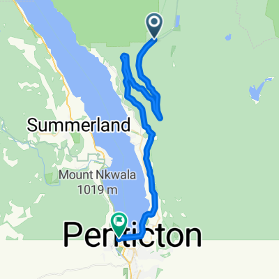
 Chute Lake - Poplar Grove KVR
- Distanz
- 39,1 km
- Aufstieg
- 71 m
- Abstieg
- 873 m
- Standort
- Summerland, British Columbia, Kanada
 N - S - Naramata Leg Warmer
- Distanz
- 30,8 km
- Aufstieg
- 325 m
- Abstieg
- 325 m
- Standort
- Summerland, British Columbia, Kanada
 Route in Summerland
- Distanz
- 8 km
- Aufstieg
- 172 m
- Abstieg
- 156 m
- Standort
- Summerland, British Columbia, Kanada
 Summerland KVR-TCT
- Distanz
- 21,4 km
- Aufstieg
- 304 m
- Abstieg
- 493 m
- Standort
- Summerland, British Columbia, Kanada
 12-09-14 Kanada: Chute Lake Resort (Kettle Valley Rail Trail)-Penticton
- Distanz
- 39,6 km
- Aufstieg
- 19 m
- Abstieg
- 819 m
- Standort
- Summerland, British Columbia, Kanada
 Summerland KVR TCT with notes
- Distanz
- 21,2 km
- Aufstieg
- 291 m
- Abstieg
- 479 m
- Standort
- Summerland, British Columbia, Kanada
 KVR - Summerland to Hope
- Distanz
- 250,4 km
- Aufstieg
- 1.095 m
- Abstieg
- 1.575 m
- Standort
- Summerland, British Columbia, Kanada
In der App öffnen