Two Bridges
- 13,9 km
- 194 m
- 194 m
- Mendota Heights, Minnesota, Vereinigte Staaten
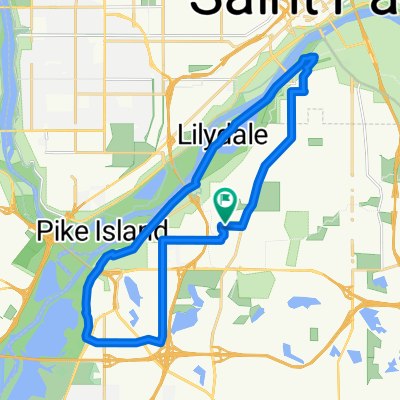
Eine Fahrradroute, die in Mendota Heights, Minnesota, Vereinigte Staaten beginnt.
Übersicht
Nehmen Sie den Highland Parkway (direkt nördlich vom Ford Parkway) zur Mississippi River Blvd und biegen Sie rechts ab. Nehmen Sie den Mississippi River Blvd nach Norden, bis Sie die Marshall/Lake-Brücke erreichen. Fahren Sie unter der Brücke weiter und biegen Sie dann nach der Brücke rechts ab, um wieder zur Marshall Ave zu gelangen. Biegen Sie rechts ab, um westlich über die Brücke zu fahren. Sobald Sie auf der Westseite der Brücke sind, biegen Sie rechts in den W River Pkwy ab. Fahren Sie weiter auf dem W River Pkwy, bis Sie die 11th Avenue erreichen, wo Sie links abbiegen und den Radweg zur 5th St nehmen (direkt nach dem Metrodome). Biegen Sie rechts auf die 5th St ab, fahren Sie an dem Metrodome vorbei und weiter ein paar Blocks bis zur Portland Avenue (Hinweis: Die 5th St hat keinen Radweg, aber der Verkehr ist normalerweise passierbar). Biegen Sie rechts auf die 5th AVENUE zur 4th Street ab (1 Block). Biegen Sie links auf die 4th St ab und gehen Sie die letzte Block zu Ihrem Ziel.
Erstellt vor 17 Jahren
Routenqualität
Ruhige Straße
5,7 km
43 %
Straße
5,2 km
39 %
Befestigt
10,9 km
(82 %)
Asphalt
10,1 km
76 %
Beton
0,7 km
5 %
Weiter mit Bikemap
Du möchtest B2B00333 55116 > 55415 via West River Rd fahren oder sie für deine eigene Reise anpassen? Folgendes kannst du mit dieser Bikemap-Route machen:
Kostenlose Testversion für 3 Tage oder einmalige Zahlung. Mehr über Bikemap Premium.
Entdecke weitere Premium-Funktionen.
Bikemap Premium aktivierenVon unserer Community
In der App öffnen