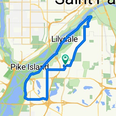
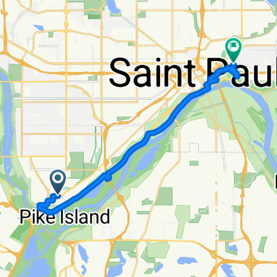
B2B00331 55417 > 55404 via Minnehaha
Eine Fahrradroute, die in Mendota Heights, Minnesota, United States of America beginnt.
Übersicht
Über diese Route
1. Take 54th St east to Minnehaha.
-
Take Minnehaha Ave bike path northwest all the way to Lake Street.
-
Cross Lake Street as Minnehaha Ave changes to 26th Ave S and continue north to 26th Street.
At this point you can either continue on 26th all the way through to Riverside and 26th. 26th is safe, but there is no bike lane. The route that is mapped is on more bike paths, as follows
-
Take a left onto 26th St. and look for the light rail trail bike path (which appears right before Hiawatha Ave).
-
Take a right onto the trail, and follow the path until it ends at 11th Avenue.
6. Take a left onto 11th, and follow the bike lane to 5th St.
7. Take a right onto 5th street. (note: 5th St is without a bike lane but traffic should be manageable. Also, veer to the left of the LRT once given the option to choose a side of the tracks).
8. Take 5th up to Portland and take a left into the bike lane.
9. Take Portland to 15th St, and take a right.
- Take 15th over the bridge and to the stoplight, where you can only turn left (because it ends in a pkg lot).
11. Turn left (onto 16th St) and follow the curve to the right. You will see your first right turn is 3rd Ave S.
12. Take a right onto 3rd Ave S which takes you to your destination. Note: Once you turn off of Portland, there are no more bike lanes on this route, but there aren't any other options unforunately. The traffic is usually manageble in this area, though, and there are wide shoulders.
Another option for step 12 is:
Continue on 16th Street to Nicollet, take a right. Take Nicollet Ave to 12th st, and turn into the bike lane there.
- -:--
- Dauer
- 12,5 km
- Distanz
- 15 m
- Aufstieg
- 12 m
- Abstieg
- ---
- Ø-Tempo
- 257 m
- Ø-Tempo
Routenqualität
Wegtypen und Untergründe entlang der Route
Wegtypen
Straße
4 km
(32 %)
Radweg
2,5 km
(20 %)
Untergründe
Befestigt
7,1 km
(57 %)
Asphalt
5,6 km
(45 %)
Beton
1,2 km
(10 %)
Weiter mit Bikemap
Diese Radroute verwenden, bearbeiten oder herunterladen
Du möchtest B2B00331 55417 > 55404 via Minnehaha fahren oder sie für deine eigene Reise anpassen? Folgendes kannst du mit dieser Bikemap-Route machen:
Gratis Funktionen
- Speichere diese Route als Favorit oder in einer Sammlung
- Kopiere & plane deine eigene Version dieser Route
- Synchronisiere deine Route mit Garmin oder Wahoo
Premium-Funktionen
Kostenlose Testversion für 3 Tage oder einmalige Zahlung. Mehr über Bikemap Premium.
- Navigiere diese Route auf iOS & Android
- Exportiere eine GPX / KML-Datei dieser Route
- Erstelle deinen individuellen Ausdruck (Jetzt kostenlos ausprobieren)
- Lade diese Route für die Offline-Navigation herunter
Entdecke weitere Premium-Funktionen.
Bikemap Premium aktivierenVon unserer Community
Mendota Heights: Andere beliebte Routen, die hier beginnen
- River Loop
- Distanz
- 15,5 km
- Aufstieg
- 99 m
- Abstieg
- 98 m
- Standort
- Mendota Heights, Minnesota, USA
- Snail-like route in Mendota Heights
- Distanz
- 14 km
- Aufstieg
- 325 m
- Abstieg
- 325 m
- Standort
- Mendota Heights, Minnesota, USA
- B2B00191 55115>55401viaRandolph/MissBlvd/LkStBridge/WRiverPkwy/WashAv
- Distanz
- 11,6 km
- Aufstieg
- 97 m
- Abstieg
- 109 m
- Standort
- Mendota Heights, Minnesota, USA
- Fort Snelling Loop
- Distanz
- 33,8 km
- Aufstieg
- 162 m
- Abstieg
- 164 m
- Standort
- Mendota Heights, Minnesota, USA
- Big Rivers, Pilot Knob, Acadia, Valley Park, ...
- Distanz
- 13,3 km
- Aufstieg
- 206 m
- Abstieg
- 206 m
- Standort
- Mendota Heights, Minnesota, USA
- B2B00914 55116>55435 via Mend Brg, 494 bike brg, 73rd
- Distanz
- 22,6 km
- Aufstieg
- 141 m
- Abstieg
- 132 m
- Standort
- Mendota Heights, Minnesota, USA
- South Minnehaha Drive 4935-4925, Minneapolis to South Minnehaha Drive, Minneapolis
- Distanz
- 39,9 km
- Aufstieg
- 10 m
- Abstieg
- 3 m
- Standort
- Mendota Heights, Minnesota, USA
- B2B00870 55116>55343 via MississippiRvBlvd/LakeStBridge/W.RiverRd/Greenway/Blake/Excel
- Distanz
- 21,2 km
- Aufstieg
- 114 m
- Abstieg
- 96 m
- Standort
- Mendota Heights, Minnesota, USA