
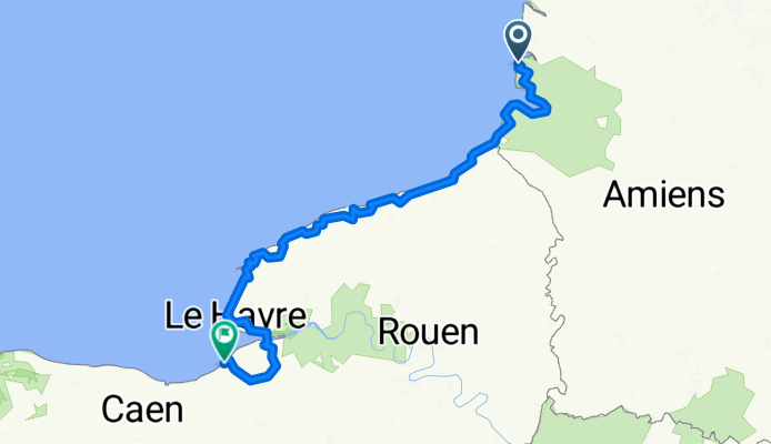
Fort-Mahon à Deauville
Eine Fahrradroute, die in Fort-Mahon-Plage, Hauts-de-France, Frankreich beginnt.
Übersicht
Über diese Route
Fahrradroute grundsätzlich maximiert
- -:--
- Dauer
- 308,2 km
- Distanz
- 757 m
- Aufstieg
- 764 m
- Abstieg
- ---
- Ø-Tempo
- ---
- Max. Höhe
Routenqualität
Wegtypen und Untergründe entlang der Route
Wegtypen
Ruhige Straße
101,7 km
(33 %)
Straße
86,3 km
(28 %)
Untergründe
Befestigt
262 km
(85 %)
Unbefestigt
9,2 km
(3 %)
Asphalt
246,6 km
(80 %)
Beton
12,3 km
(4 %)
Weiter mit Bikemap
Diese Radroute verwenden, bearbeiten oder herunterladen
Du möchtest Fort-Mahon à Deauville fahren oder sie für deine eigene Reise anpassen? Folgendes kannst du mit dieser Bikemap-Route machen:
Gratis Funktionen
- Speichere diese Route als Favorit oder in einer Sammlung
- Kopiere & plane deine eigene Version dieser Route
- Teile sie in Etappen ein, um eine mehrtägige Tour zu erstellen
- Synchronisiere deine Route mit Garmin oder Wahoo
Premium-Funktionen
Kostenlose Testversion für 3 Tage oder einmalige Zahlung. Mehr über Bikemap Premium.
- Navigiere diese Route auf iOS & Android
- Exportiere eine GPX / KML-Datei dieser Route
- Erstelle deinen individuellen Ausdruck (Jetzt kostenlos ausprobieren)
- Lade diese Route für die Offline-Navigation herunter
Entdecke weitere Premium-Funktionen.
Bikemap Premium aktivierenVon unserer Community
Fort-Mahon-Plage: Andere beliebte Routen, die hier beginnen
 Avenue des Pins 11, Quend nach Avenue des Pins 11, Quend
- Distanz
- 45,5 km
- Aufstieg
- 70 m
- Abstieg
- 72 m
- Standort
- Fort-Mahon-Plage, Hauts-de-France, Frankreich
 409 Rue du Général de Gaulle, Fort-Mahon-Plage à Saint-Quentin-en-Tourmont
- Distanz
- 15,3 km
- Aufstieg
- 52 m
- Abstieg
- 57 m
- Standort
- Fort-Mahon-Plage, Hauts-de-France, Frankreich
 De 2–6 Avenue Foch, Quend à 1–3 Rue de la Mairie, Wail
- Distanz
- 78 km
- Aufstieg
- 376 m
- Abstieg
- 352 m
- Standort
- Fort-Mahon-Plage, Hauts-de-France, Frankreich
 439 Rue du Général de Gaulle, Fort-Mahon-Plage à Eurovélo Quatre-Véloroute de l'Europe Centrale, Fort-Mahon-Plage
- Distanz
- 1,4 km
- Aufstieg
- 6 m
- Abstieg
- 7 m
- Standort
- Fort-Mahon-Plage, Hauts-de-France, Frankreich
 15 Allée de Bretagne, Fort-Mahon-Plage à 1 Plaine du Royon, Fort-Mahon-Plage
- Distanz
- 1,5 km
- Aufstieg
- 0 m
- Abstieg
- 4 m
- Standort
- Fort-Mahon-Plage, Hauts-de-France, Frankreich
 De Boulevard maritime Nord 55, Fort-Mahon-Plage à Camping Le Ridin, Le Crotoy
- Distanz
- 18,2 km
- Aufstieg
- 52 m
- Abstieg
- 56 m
- Standort
- Fort-Mahon-Plage, Hauts-de-France, Frankreich
 89 Rue Lavoisier, Fort-Mahon-Plage à 89 Rue Lavoisier, Fort-Mahon-Plage
- Distanz
- 24,4 km
- Aufstieg
- 197 m
- Abstieg
- 189 m
- Standort
- Fort-Mahon-Plage, Hauts-de-France, Frankreich
 Fort-Mahon - Paris
- Distanz
- 301,8 km
- Aufstieg
- 422 m
- Abstieg
- 376 m
- Standort
- Fort-Mahon-Plage, Hauts-de-France, Frankreich
In der App öffnen