
Mrcina - 52 - Enduro
Eine Fahrradroute, die in Kašina, Grad Zagreb, Croatia beginnt.
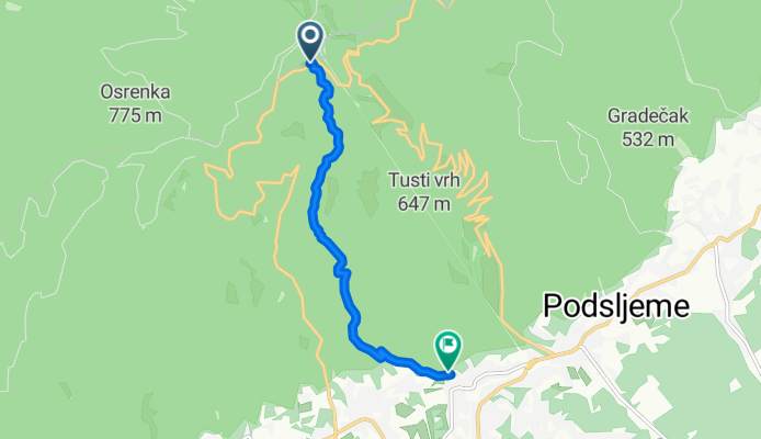
Übersicht
Über diese Route
WATCH OUT FOR HIKERS on these trails!!!
One of my favourite routes. Starts from the road on the top of the mountain (after the bus stop, 10m on the left, near the fence). Starts as a very narrow and steep singletrack that ends on a dirt road but after 5m you continue on the singletrack until you get to a short and punchy climb you get to a gravel road on which you have a fast and wide dirt road (stick to the right, do not climb the hill in front of you). After 100-200m you must not miss a short entrance to a singletrack path again (trail number 52). After a short singletrack you return again to a dirt wide road then again after 100-200m you stick to the left and look for an entrance to a short singletrack which connects you with enduro trail "Opušteno" until the end.
WATCH OUT FOR HIKERS ON TRAIL 52!!
- -:--
- Dauer
- 6,4 km
- Distanz
- 71 m
- Aufstieg
- 763 m
- Abstieg
- ---
- Ø-Tempo
- ---
- Ø-Tempo

Weiter mit Bikemap
Diese Radroute verwenden, bearbeiten oder herunterladen
Du möchtest Mrcina - 52 - Enduro fahren oder sie für deine eigene Reise anpassen? Folgendes kannst du mit dieser Bikemap-Route machen:
Gratis Funktionen
- Speichere diese Route als Favorit oder in einer Sammlung
- Kopiere & plane deine eigene Version dieser Route
- Synchronisiere deine Route mit Garmin oder Wahoo
Premium-Funktionen
Kostenlose Testversion für 3 Tage oder einmalige Zahlung. Mehr über Bikemap Premium.
- Navigiere diese Route auf iOS & Android
- Exportiere eine GPX / KML-Datei dieser Route
- Erstelle deinen individuellen Ausdruck (Jetzt kostenlos ausprobieren)
- Lade diese Route für die Offline-Navigation herunter
Entdecke weitere Premium-Funktionen.
Bikemap Premium aktivierenVon unserer Community
Kašina: Andere beliebte Routen, die hier beginnen
 Sljeme-Stubičke Toplice-Oroslavlje-Stub.Slatina-Bistra-Zagreb
- Distanz
- 58,9 km
- Aufstieg
- 131 m
- Abstieg
- 962 m
- Standort
- Kašina, Zagreb Stadt, Kroatien
 Zagreb - Markuševačka trnava
- Distanz
- 26,3 km
- Aufstieg
- 751 m
- Abstieg
- 751 m
- Standort
- Kašina, Zagreb Stadt, Kroatien
 MC Trail
- Distanz
- 5,5 km
- Aufstieg
- 37 m
- Abstieg
- 655 m
- Standort
- Kašina, Zagreb Stadt, Kroatien
 Sljeme staza 14 - Lonjščina alternativni uspon - spoj na Lojstek
- Distanz
- 0,9 km
- Aufstieg
- 13 m
- Abstieg
- 117 m
- Standort
- Kašina, Zagreb Stadt, Kroatien
 Sljeme - staza 69
- Distanz
- 7,9 km
- Aufstieg
- 159 m
- Abstieg
- 781 m
- Standort
- Kašina, Zagreb Stadt, Kroatien
 Sljeme 1 (Markuševec - Goroščica - Markuševac)
- Distanz
- 22,4 km
- Aufstieg
- 682 m
- Abstieg
- 680 m
- Standort
- Kašina, Zagreb Stadt, Kroatien
 Sljeme - Enduro 1
- Distanz
- 6,1 km
- Aufstieg
- 75 m
- Abstieg
- 790 m
- Standort
- Kašina, Zagreb Stadt, Kroatien
 Prva vožnja 19.4.2025.
- Distanz
- 36,1 km
- Aufstieg
- 459 m
- Abstieg
- 679 m
- Standort
- Kašina, Zagreb Stadt, Kroatien
In der App öffnen