

B2B00248 55125>55112 viaRadio/Inwood/Ideal/OlsonLk/Demontr/WarnerRd/Lake/BaldEag/H2/Centv/CtyJ
Eine Fahrradroute, die in Woodbury, Minnesota, Vereinigte Staaten beginnt.
Übersicht
Über diese Route
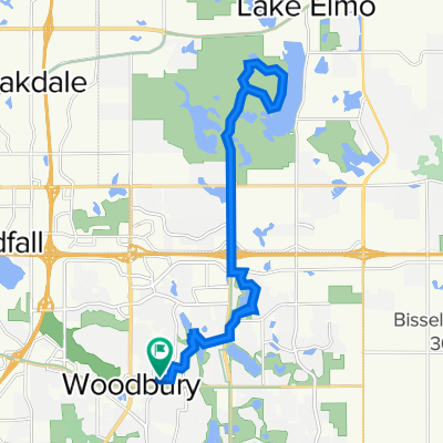
North on Radio Dr. It becomes Inwood Av. Follow Inwood to Stillwater Rd. Turn left and go to Ideal. Turn right and follow Ideal north. It becomes Olson Lake Rd. At 50th St. turn right to Demontreville Trail. Follow Demotreville to the left around the lake to Highlands Trail N. up the hill. At the top of the hill turn left at Hytrail Av. N. On your left will be the entrance to the Gateway Trail. Take the path down the hill and through a small forest. It curves around and suddenly you are at the entrance to the Gateway. Turn right and go through the tunnel under highway 36. Just past the end of the tunnel there is a hairpin turn to the left up to a parking lot and out to 60th St. N. At the end of this road is Hilton Trail. Turn right and go to the next corner and turn left at 62nd St. N. Go to Warner Rd. and turn right. Follow Warner Av. north past Stillwater Rd. until you reach Locust St. Turn left over to Mahtomedi Av./244. Turn right at Mahtomedi and follow around White Bear Lake past the Yacht Club until you reach Highway 96/LakeAv. Turn left and follow around until you reach Northwest Av. Angle off to the right on Northwest Av. until you reach Buffalo St. Turn left and cross highway 61. Just across the railroad tracks turn left on Hugo Rd. Follow Hugo Rd. until it curves to the right and becomes Park Av. Follow Park Av. to Bald Eagle Lake. Turn left at Bald Eagle Blvd and go around the lake until you reach Cty. Rd. H2. Turn left on H2 and go west until you reach Centerville Rd. Turn right at Centerville Rd. and go north until you reach Cty Rd. J. on the left. Turn left at Cty J and continue on J west past Hodgson Rd./ Lexington Av. and 35W. Continue on until you reach Coral Sea St. Turn left to your destination.
- -:--
- Dauer
- 43,7 km
- Distanz
- 134 m
- Aufstieg
- 164 m
- Abstieg
- ---
- Ø-Tempo
- 319 m
- Max. Höhe
Routenqualität
Wegtypen und Untergründe entlang der Route
Wegtypen
Straße
16,4 km
(38 %)
Radweg
12,1 km
(28 %)
Untergründe
Befestigt
31,3 km
(71 %)
Unbefestigt
0 km
(<1 %)
Asphalt
30,7 km
(70 %)
Befestigt (undefiniert)
0,6 km
(1 %)
Weiter mit Bikemap
Diese Radroute verwenden, bearbeiten oder herunterladen
Du möchtest B2B00248 55125>55112 viaRadio/Inwood/Ideal/OlsonLk/Demontr/WarnerRd/Lake/BaldEag/H2/Centv/CtyJ fahren oder sie für deine eigene Reise anpassen? Folgendes kannst du mit dieser Bikemap-Route machen:
Gratis Funktionen
- Speichere diese Route als Favorit oder in einer Sammlung
- Kopiere & plane deine eigene Version dieser Route
- Synchronisiere deine Route mit Garmin oder Wahoo
Premium-Funktionen
Kostenlose Testversion für 3 Tage oder einmalige Zahlung. Mehr über Bikemap Premium.
- Navigiere diese Route auf iOS & Android
- Exportiere eine GPX / KML-Datei dieser Route
- Erstelle deinen individuellen Ausdruck (Jetzt kostenlos ausprobieren)
- Lade diese Route für die Offline-Navigation herunter
Entdecke weitere Premium-Funktionen.
Bikemap Premium aktivierenVon unserer Community
Woodbury: Andere beliebte Routen, die hier beginnen
 B2B00288 55125>55344 via Mndt Hght Rd, 494, 86th St
- Distanz
- 46,8 km
- Aufstieg
- 248 m
- Abstieg
- 283 m
- Standort
- Woodbury, Minnesota, Vereinigte Staaten
 Neighborhood loop
- Distanz
- 19,5 km
- Aufstieg
- 114 m
- Abstieg
- 113 m
- Standort
- Woodbury, Minnesota, Vereinigte Staaten
 Slow ride in Woodbury
- Distanz
- 7,8 km
- Aufstieg
- 101 m
- Abstieg
- 106 m
- Standort
- Woodbury, Minnesota, Vereinigte Staaten
 Afton Ride
- Distanz
- 51,2 km
- Aufstieg
- 290 m
- Abstieg
- 304 m
- Standort
- Woodbury, Minnesota, Vereinigte Staaten
 1208 St Johns Dr, Woodbury to 1208 St Johns Dr, Woodbury
- Distanz
- 8 km
- Aufstieg
- 26 m
- Abstieg
- 28 m
- Standort
- Woodbury, Minnesota, Vereinigte Staaten
 B2B00770 55125>55101 via Upper Afton Rd, E 6th St
- Distanz
- 15,6 km
- Aufstieg
- 81 m
- Abstieg
- 158 m
- Standort
- Woodbury, Minnesota, Vereinigte Staaten
 10870 Ashley Ln, Woodbury to 10869 Ashley Ln, Woodbury
- Distanz
- 28,9 km
- Aufstieg
- 178 m
- Abstieg
- 177 m
- Standort
- Woodbury, Minnesota, Vereinigte Staaten
 Lake Elmo Ride
- Distanz
- 24,1 km
- Aufstieg
- 113 m
- Abstieg
- 113 m
- Standort
- Woodbury, Minnesota, Vereinigte Staaten
In der App öffnen