

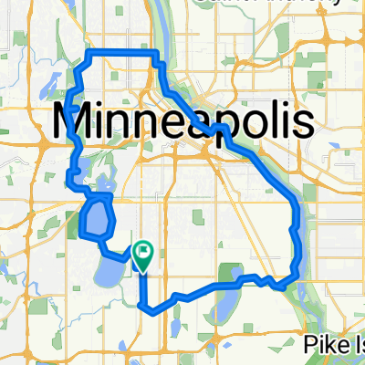
B2B00428 55406>55112 via46th/FordBridge/MissipBlvd/Pelham/Raymond/Como/Hamline/Lex
Eine Fahrradroute, die in Richfield, Minnesota, Vereinigte Staaten beginnt.
Übersicht
Über diese Route
Take 46th Street east to the Ford Bridge. After crossing the bridge turn immediately to the right and circle around under the bridge to go north on Mississippi Blvd. There is a bike path or the road.Take Mississippi Blvd. north past Summit and around the loop near St. Thomas. Continue on Mississippi under the LakeSt./Marshall Bridge.
At the next intersection turn right on to PelhamBlvd. and head up the hill past the Town & Country Golf course. Continue on over I94 to Myrtle Avenue. Turn right at Myrtle to Raymond Av. Turn left and continue on Raymond through S. St. Anthony Pk. to Como Av. Turn right at Como and continue on Como past the State Fair until you reach Hamline Av. Turn left at Hamline and continue on Hamline past Larpenteur, Cty. B1, B2, C. One block past Cty. C turn right on Woodhill Drive. Follow Woodhill Drive to Lexington. Turn left at Lexington and continue on Lexington past 694 to Cty. Rd. F. Turn left on F and follow to your destination.
- -:--
- Dauer
- 23,3 km
- Distanz
- 144 m
- Aufstieg
- 108 m
- Abstieg
- ---
- Ø-Tempo
- 290 m
- Max. Höhe
Routenqualität
Wegtypen und Untergründe entlang der Route
Wegtypen
Straße
11,5 km
(49 %)
Radweg
5,9 km
(25 %)
Untergründe
Befestigt
16 km
(68 %)
Asphalt
13,4 km
(57 %)
Befestigt (undefiniert)
1,3 km
(6 %)
Weiter mit Bikemap
Diese Radroute verwenden, bearbeiten oder herunterladen
Du möchtest B2B00428 55406>55112 via46th/FordBridge/MissipBlvd/Pelham/Raymond/Como/Hamline/Lex fahren oder sie für deine eigene Reise anpassen? Folgendes kannst du mit dieser Bikemap-Route machen:
Gratis Funktionen
- Speichere diese Route als Favorit oder in einer Sammlung
- Kopiere & plane deine eigene Version dieser Route
- Synchronisiere deine Route mit Garmin oder Wahoo
Premium-Funktionen
Kostenlose Testversion für 3 Tage oder einmalige Zahlung. Mehr über Bikemap Premium.
- Navigiere diese Route auf iOS & Android
- Exportiere eine GPX / KML-Datei dieser Route
- Erstelle deinen individuellen Ausdruck (Jetzt kostenlos ausprobieren)
- Lade diese Route für die Offline-Navigation herunter
Entdecke weitere Premium-Funktionen.
Bikemap Premium aktivierenVon unserer Community
Richfield: Andere beliebte Routen, die hier beginnen
 the Bike & Bistro's premiere tour
- Distanz
- 6,7 km
- Aufstieg
- 26 m
- Abstieg
- 9 m
- Standort
- Richfield, Minnesota, Vereinigte Staaten
 Day 1 Lag 3
- Distanz
- 106,3 km
- Aufstieg
- 327 m
- Abstieg
- 359 m
- Standort
- Richfield, Minnesota, Vereinigte Staaten
 B2B00042 55419 > 55422 via Greenway, Cedar Lake, and Theo Wirth
- Distanz
- 13,3 km
- Aufstieg
- 61 m
- Abstieg
- 59 m
- Standort
- Richfield, Minnesota, Vereinigte Staaten
 30 miler
- Distanz
- 48,5 km
- Aufstieg
- 308 m
- Abstieg
- 310 m
- Standort
- Richfield, Minnesota, Vereinigte Staaten
 East 46th Street 180, Minneapolis to Union Depot, Saint Paul
- Distanz
- 22,2 km
- Aufstieg
- 153 m
- Abstieg
- 185 m
- Standort
- Richfield, Minnesota, Vereinigte Staaten
 B2B00920 55407>55438 via Portland, Mnnha Pwy, Logan, Hylund Prk
- Distanz
- 23,7 km
- Aufstieg
- 98 m
- Abstieg
- 95 m
- Standort
- Richfield, Minnesota, Vereinigte Staaten
 B2B00001 55419 > 55416 via Lake Harriet, 38th, France
- Distanz
- 8,4 km
- Aufstieg
- 75 m
- Abstieg
- 76 m
- Standort
- Richfield, Minnesota, Vereinigte Staaten
 Perfect Circle Minneapolis Bike Route
- Distanz
- 36,4 km
- Aufstieg
- 117 m
- Abstieg
- 117 m
- Standort
- Richfield, Minnesota, Vereinigte Staaten
In der App öffnen