

Earl Bales without Phil Nic
Eine Fahrradroute, die in Toronto, Ontario, Canada beginnt.
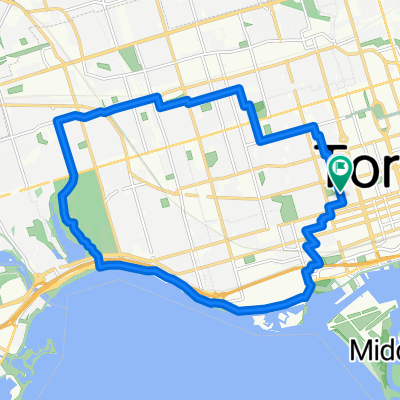
Übersicht
Über diese Route
Hot, humid, started raining at the end, it was good. Went partway down the hill and then turned left early, dragged my bike up a steep dirt hill then found myself at the campfire area, circled around and kept going around the park for a while. It's impossible to represent on this stupid map, think it was closer to 15 km or o but its really hard to tell. mood 8/10 brutality 4/10
- -:--
- Dauer
- 12,3 km
- Distanz
- 52 m
- Aufstieg
- 49 m
- Abstieg
- ---
- Ø-Tempo
- ---
- Ø-Tempo
Weiter mit Bikemap
Diese Radroute verwenden, bearbeiten oder herunterladen
Du möchtest Earl Bales without Phil Nic fahren oder sie für deine eigene Reise anpassen? Folgendes kannst du mit dieser Bikemap-Route machen:
Gratis Funktionen
- Speichere diese Route als Favorit oder in einer Sammlung
- Kopiere & plane deine eigene Version dieser Route
- Synchronisiere deine Route mit Garmin oder Wahoo
Premium-Funktionen
Kostenlose Testversion für 3 Tage oder einmalige Zahlung. Mehr über Bikemap Premium.
- Navigiere diese Route auf iOS & Android
- Exportiere eine GPX / KML-Datei dieser Route
- Erstelle deinen individuellen Ausdruck (Jetzt kostenlos ausprobieren)
- Lade diese Route für die Offline-Navigation herunter
Entdecke weitere Premium-Funktionen.
Bikemap Premium aktivierenVon unserer Community
Toronto: Andere beliebte Routen, die hier beginnen
 East York to Indian Line campground
- Distanz
- 47,4 km
- Aufstieg
- 242 m
- Abstieg
- 143 m
- Standort
- Toronto, Ontario, Kanada
 Cabana
- Distanz
- 13,1 km
- Aufstieg
- 91 m
- Abstieg
- 93 m
- Standort
- Toronto, Ontario, Kanada
 2020-05-20 Morning round DT Toronto
- Distanz
- 34,9 km
- Aufstieg
- 168 m
- Abstieg
- 165 m
- Standort
- Toronto, Ontario, Kanada
 High Park
- Distanz
- 18,4 km
- Aufstieg
- 63 m
- Abstieg
- 63 m
- Standort
- Toronto, Ontario, Kanada
 Route to Fit 4 Less
- Distanz
- 85,5 km
- Aufstieg
- 416 m
- Abstieg
- 417 m
- Standort
- Toronto, Ontario, Kanada
 Lawrence West to Union Station Via Sunnybrook, Taylor Creek, Boardwalk, Tommy Thompson Park
- Distanz
- 42,3 km
- Aufstieg
- 187 m
- Abstieg
- 282 m
- Standort
- Toronto, Ontario, Kanada
 Cedarvale Park
- Distanz
- 5,9 km
- Aufstieg
- 39 m
- Abstieg
- 39 m
- Standort
- Toronto, Ontario, Kanada
 - Short steep climbs & fast descents in the Beach
- Distanz
- 5,4 km
- Aufstieg
- 107 m
- Abstieg
- 110 m
- Standort
- Toronto, Ontario, Kanada
In der App öffnen