
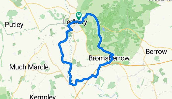
The Ledbury Loop
Eine Fahrradroute, die in Ledbury, England, United Kingdom beginnt.
Übersicht
Über diese Route
<span style="font-family: SassoonPrimaryType; font-size: medium;"><font face="SassoonPrimaryType" size="4"><span>
The Ledbury Loop explores the Herefordshire/Gloucestershire border; an area famous for poets and wild daffodils. This fully signed route goes
south from Ledbury to Dymock and, after crossing the ford at Clenchers
Mill, climbs steadily over hills at Eastnor. You are strongly advised to
cross the ford by the footbridge as the stream bed is notoriously slippery.
The Loop is part of the National Byway, a 3000 mile leisure cycling route
around Britain that links places of geographic, historic and cultural interest. </span></font></span>
- -:--
- Dauer
- 24,7 km
- Distanz
- 181 m
- Aufstieg
- 180 m
- Abstieg
- ---
- Ø-Tempo
- ---
- Ø-Tempo
Routenqualität
Wegtypen und Untergründe entlang der Route
Wegtypen
Ruhige Straße
14,4 km
(58 %)
Vielbefahrene Straße
4,1 km
(17 %)
Untergründe
Befestigt
0,7 km
(3 %)
Asphalt
0,7 km
(3 %)
Befestigt (undefiniert)
0 km
(<1 %)
Undefiniert
24 km
(97 %)
Weiter mit Bikemap
Diese Radroute verwenden, bearbeiten oder herunterladen
Du möchtest The Ledbury Loop fahren oder sie für deine eigene Reise anpassen? Folgendes kannst du mit dieser Bikemap-Route machen:
Gratis Funktionen
- Speichere diese Route als Favorit oder in einer Sammlung
- Kopiere & plane deine eigene Version dieser Route
- Synchronisiere deine Route mit Garmin oder Wahoo
Premium-Funktionen
Kostenlose Testversion für 3 Tage oder einmalige Zahlung. Mehr über Bikemap Premium.
- Navigiere diese Route auf iOS & Android
- Exportiere eine GPX / KML-Datei dieser Route
- Erstelle deinen individuellen Ausdruck (Jetzt kostenlos ausprobieren)
- Lade diese Route für die Offline-Navigation herunter
Entdecke weitere Premium-Funktionen.
Bikemap Premium aktivierenVon unserer Community
Ledbury: Andere beliebte Routen, die hier beginnen
 The Dog from Ledbury
- Distanz
- 64,7 km
- Aufstieg
- 520 m
- Abstieg
- 520 m
- Standort
- Ledbury, England, Vereinigtes Königreich
 Ledbury VultureFish
- Distanz
- 52,9 km
- Aufstieg
- 467 m
- Abstieg
- 432 m
- Standort
- Ledbury, England, Vereinigtes Königreich
 LedburyCC.org - Dymock 9
- Distanz
- 14,4 km
- Aufstieg
- 65 m
- Abstieg
- 63 m
- Standort
- Ledbury, England, Vereinigtes Königreich
 Ledbury Bosbury Balloon
- Distanz
- 18,2 km
- Aufstieg
- 143 m
- Abstieg
- 143 m
- Standort
- Ledbury, England, Vereinigtes Königreich
 Ledbury Spiked Sausage Dog
- Distanz
- 44,9 km
- Aufstieg
- 541 m
- Abstieg
- 541 m
- Standort
- Ledbury, England, Vereinigtes Königreich
 Liesure Ride 2010-03-13
- Distanz
- 34,4 km
- Aufstieg
- 228 m
- Abstieg
- 236 m
- Standort
- Ledbury, England, Vereinigtes Königreich
 Ledbury - Staplow - Mathon - Colwall - Loop
- Distanz
- 31,4 km
- Aufstieg
- 207 m
- Abstieg
- 212 m
- Standort
- Ledbury, England, Vereinigtes Königreich
 Medium route with a couple of nice hills!!
- Distanz
- 46,9 km
- Aufstieg
- 488 m
- Abstieg
- 498 m
- Standort
- Ledbury, England, Vereinigtes Königreich
In der App öffnen