

Armidale to Guyra and back via Black mountain
Eine Fahrradroute, die in Armidale, New South Wales, Australia beginnt.
Übersicht
Über diese Route
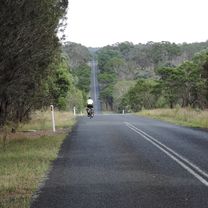
This is just one of multiple circuits from Armidale to Guyra. It is hilly because, the terrain around here is always hilly! and because Guyra is significantly higher than Armidale. This mapping tool considerably underestimates the climbing, which is actually around 1100 m. We choose to do the harder section via Booroolong creek first and return via Black Mountain. The road is sealed up to the turn off onto Old Armidale road at about 28 km. From there until Baldersleigh Rd (42 km) it is unsealed, including a steep climb out of Booroolong creek and sometimes significant corrugations in places. On the return trip, the road is sealed apart from about 8 km along Toms Gully Rd. This road is mostly kept in quite good condition, but we have encountered bad corrugations on corners at times. The route is pleasant at most times of year but is particularly delightful in Spring, when the road can be lined with flowers in places. Don't forget to stop in Guyra for a coffee and cake.
- -:--
- Dauer
- 99,7 km
- Distanz
- 624 m
- Aufstieg
- 625 m
- Abstieg
- ---
- Ø-Tempo
- ---
- Ø-Tempo

Fotos von der Route


Weiter mit Bikemap
Diese Radroute verwenden, bearbeiten oder herunterladen
Du möchtest Armidale to Guyra and back via Black mountain fahren oder sie für deine eigene Reise anpassen? Folgendes kannst du mit dieser Bikemap-Route machen:
Gratis Funktionen
- Speichere diese Route als Favorit oder in einer Sammlung
- Kopiere & plane deine eigene Version dieser Route
- Synchronisiere deine Route mit Garmin oder Wahoo
Premium-Funktionen
Kostenlose Testversion für 3 Tage oder einmalige Zahlung. Mehr über Bikemap Premium.
- Navigiere diese Route auf iOS & Android
- Exportiere eine GPX / KML-Datei dieser Route
- Erstelle deinen individuellen Ausdruck (Jetzt kostenlos ausprobieren)
- Lade diese Route für die Offline-Navigation herunter
Entdecke weitere Premium-Funktionen.
Bikemap Premium aktivierenVon unserer Community
Armidale: Andere beliebte Routen, die hier beginnen
 Kelly's plains circuit
- Distanz
- 19,5 km
- Aufstieg
- 179 m
- Abstieg
- 179 m
- Standort
- Armidale, New South Wales, Australien
 Armidale to Uralla via Hawthorne Dr
- Distanz
- 72,4 km
- Aufstieg
- 463 m
- Abstieg
- 464 m
- Standort
- Armidale, New South Wales, Australien
 Armidale, Toms Gully, Puddledock loop
- Distanz
- 71,6 km
- Aufstieg
- 607 m
- Abstieg
- 607 m
- Standort
- Armidale, New South Wales, Australien
 Armidale to Point Lookout loop
- Distanz
- 226,3 km
- Aufstieg
- 4.225 m
- Abstieg
- 4.225 m
- Standort
- Armidale, New South Wales, Australien
 Armidale Tourist Information Centre to Dangars Gorge return
- Distanz
- 47 km
- Aufstieg
- 355 m
- Abstieg
- 353 m
- Standort
- Armidale, New South Wales, Australien
 New England Cycle Trail South
- Distanz
- 353,4 km
- Aufstieg
- 999 m
- Abstieg
- 1.577 m
- Standort
- Armidale, New South Wales, Australien
 Armidale to Gara river crossing along Herbert Park Rd
- Distanz
- 48,3 km
- Aufstieg
- 516 m
- Abstieg
- 515 m
- Standort
- Armidale, New South Wales, Australien
 Avoiding the Waterfall Way from Armidale
- Distanz
- 92,5 km
- Aufstieg
- 708 m
- Abstieg
- 708 m
- Standort
- Armidale, New South Wales, Australien
In der App öffnen