


Camino portugues
From Pontevedra to Pontecesures
Eine Fahrradroute, die in Pontevedra, Galicien, Spanien beginnt.
Übersicht
Über diese Route
2
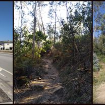
The route stats going around forests and vineyards, with lots of pilgrims walking in the first part of the day. Long satisfying lunch in Caldas de Reis. Lost the way and went around quite a bit afterwards. :) Winding left and right to avoid both the highway and the "N", busy road, the path goes through picturesque villages, and some paved, beautiful forest roads, to end up in the east, hilly part of Pontecesures.
- -:--
- Dauer
- 42,7 km
- Distanz
- 334 m
- Aufstieg
- 343 m
- Abstieg
- ---
- Ø-Tempo
- ---
- Max. Höhe
Irina Dumitrașcu
Erstellt vor 7 Jahren
Teil von
Camino portugues
6 Etappen
Weiter mit Bikemap
Diese Radroute verwenden, bearbeiten oder herunterladen
Du möchtest From Pontevedra to Pontecesures fahren oder sie für deine eigene Reise anpassen? Folgendes kannst du mit dieser Bikemap-Route machen:
Gratis Funktionen
- Speichere diese Route als Favorit oder in einer Sammlung
- Kopiere & plane deine eigene Version dieser Route
- Synchronisiere deine Route mit Garmin oder Wahoo
Premium-Funktionen
Kostenlose Testversion für 3 Tage oder einmalige Zahlung. Mehr über Bikemap Premium.
- Navigiere diese Route auf iOS & Android
- Exportiere eine GPX / KML-Datei dieser Route
- Erstelle deinen individuellen Ausdruck (Jetzt kostenlos ausprobieren)
- Lade diese Route für die Offline-Navigation herunter
Entdecke weitere Premium-Funktionen.
Bikemap Premium aktivierenVon unserer Community
Pontevedra: Andere beliebte Routen, die hier beginnen


 Stage #2-5: Pontevedra to Vilagarcia de Arousa (Cambados for lunch)0
- 40,2 km
- 693 m
- 708 m
- Pontevedra, Galicien, Spanien


In der App öffnen