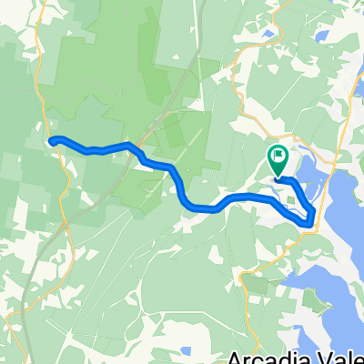
Blackalls Park Public School to Toronto Pool +
Eine Fahrradroute, die in Fennell Bay, New South Wales, Australien beginnt.
Übersicht
Über diese Route
Verlasse die Blackalls Park Public School (Tor an der Ecke Todd & Rupert Streets) und fahre ostwärts bergab.
Biege rechts in die Fassifern Street vor der Hauptstraße ab und fahre etwa 200 m nach Süden. Biege links in die Centre Street ab und fahre ostwärts bis zur South Parade.
Nutze die Breite der South Parade, um auf der Straße südostwärts zu fahren und überquere den Stoney Creek (ca. 900 m). Überquere die Stoney Creek Brücke und folge der Cook Street südwärts (ca. 600 m), biege dann rechts in die The Boulevard (auch als Awaba Road bekannt) ab und fahre westnordwestlich etwa 1000 m bis zur Kreuzung mit der Carleton Street. Du befindest dich am Toronto Swim Centre.
Fahre ungefähr 200 m südwärts „bergauf“ die Carleton Street entlang. Biege links in die Fenton Avenue ab und fahre ca. 400 m ostwärts.
Biege links in die Glenfield Road ab und fahre die sanfte Steigung von 150 m nach Norden hinunter, um wieder auf die Awaba Road (alias The Boulevard) zu gelangen für einen flachen 1100 m 'Sprint' bis zur Cary Street.
Biege links an der CALTEX-Tankstelle ab und fahre etwa 400 m nördlich am Rand der Cary Street entlang zum Einstiegspunkt des Greenway-Radwegs gegenüber der Victory Parade.
Biege links ab und folge dem Greenway-Weg ca. 600 m bis zur Kreuzung zum alten Railway North Parade [auf der anderen Seite der alten Bahntrassen].
Fahre generell nordwestlich ca. 430 Meter bis zur Faucett Street Kreuzung. Biege scharf rechts in die Bayview Avenue ab und folge der asphaltierten Straße zum Eingang der Blackalls Park Parklandschaft und dem Spielplatz.
(Optionaler Halt auf deiner Fahrt oder...)
Biege links ab und fahre 450 Meter westwärts die Blackall Avenue entlang, überquere North Parade und den Verbindungsweg zurück zum Toronto-Fassifern Greenway-Radweg.
Fahre etwa 620 Meter nordwärts und verlasse den Weg links über den 50 m langen Verbindungsweg zur Reynolds Street. Fahre etwa 120 Meter westwärts, dann links auf die Main Road (auch bekannt als South Parade).
Nach knapp weiteren 200 Metern biege rechts in die Rupert Street ab und fahre die letzten 600 Meter bis zum Schultor, wo die heutige 10-Kilometer-Tour begann.
- -:--
- Dauer
- 10,5 km
- Distanz
- 67 m
- Aufstieg
- 66 m
- Abstieg
- ---
- Ø-Tempo
- ---
- Max. Höhe
Weiter mit Bikemap
Diese Radroute verwenden, bearbeiten oder herunterladen
Du möchtest Blackalls Park Public School to Toronto Pool + fahren oder sie für deine eigene Reise anpassen? Folgendes kannst du mit dieser Bikemap-Route machen:
Gratis Funktionen
- Speichere diese Route als Favorit oder in einer Sammlung
- Kopiere & plane deine eigene Version dieser Route
- Synchronisiere deine Route mit Garmin oder Wahoo
Premium-Funktionen
Kostenlose Testversion für 3 Tage oder einmalige Zahlung. Mehr über Bikemap Premium.
- Navigiere diese Route auf iOS & Android
- Exportiere eine GPX / KML-Datei dieser Route
- Erstelle deinen individuellen Ausdruck (Jetzt kostenlos ausprobieren)
- Lade diese Route für die Offline-Navigation herunter
Entdecke weitere Premium-Funktionen.
Bikemap Premium aktivierenVon unserer Community
Fennell Bay: Andere beliebte Routen, die hier beginnen
 Blackalls Park Public School to Toronto Pool +
- Distanz
- 10,5 km
- Aufstieg
- 67 m
- Abstieg
- 66 m
- Standort
- Fennell Bay, New South Wales, Australien
 Around Fennell Bay & connected suburbs
- Distanz
- 13,2 km
- Aufstieg
- 82 m
- Abstieg
- 94 m
- Standort
- Fennell Bay, New South Wales, Australien
 Another Local Suburban Exercise Course
- Distanz
- 11,9 km
- Aufstieg
- 83 m
- Abstieg
- 86 m
- Standort
- Fennell Bay, New South Wales, Australien
 Blackalls Park - THS - Toronto - home - 10.5km
- Distanz
- 10,7 km
- Aufstieg
- 81 m
- Abstieg
- 80 m
- Standort
- Fennell Bay, New South Wales, Australien
 Toronto High School, Coles, home
- Distanz
- 16,7 km
- Aufstieg
- 84 m
- Abstieg
- 88 m
- Standort
- Fennell Bay, New South Wales, Australien
 Circumnavigate Edmonds Bay/Stoney Creek
- Distanz
- 9,2 km
- Aufstieg
- 54 m
- Abstieg
- 63 m
- Standort
- Fennell Bay, New South Wales, Australien
 BPPS to Freemans Waterhole Subway
- Distanz
- 28,6 km
- Aufstieg
- 197 m
- Abstieg
- 197 m
- Standort
- Fennell Bay, New South Wales, Australien
 13.5km plus Suburban Run
- Distanz
- 14,2 km
- Aufstieg
- 80 m
- Abstieg
- 83 m
- Standort
- Fennell Bay, New South Wales, Australien
In der App öffnen


