

Blackalls Park Public School to Pippi's Hotel, Speers Point
Eine Fahrradroute, die in Fennell Bay, New South Wales, Australia beginnt.
Übersicht
Über diese Route
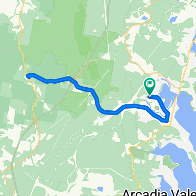
i. Leave Blackalls Park Public School from the gate at corner of Todd & Rupert Streets. Travel NE on Rupert Street.
-
Follow the Main Road (Fassiern Street) to the Railway Station viaduct then onto The Fennell Bay traffic lights adjacent to the Fennell Bay Public School.
-
Turn LEFT travelling NORTH to the next traffic lights (1.14km away) and turn RIGHT into Enterprise Way travelling 170m EAST to Haydenbrook Road.
-
Execute a left turn into Haydenbrook Road and travel its full length (generally NORTH) to Marmong Street (1.1km).
-
Turn LEFT into Marmong Street and travel just 185m then take a RIGHT turn into Aspinall Street. Travl the full lenght of Aspinall Street (NORTH EAST) past Booragul Public School to join the Greenway-Cycleway 250m away at the waterfront.
-
Follow the Greenway-Cycleway roughly WEST to the Main Road (T C FRITH Avenue).
-
Travel NNE alongside T C FRITH Avenue to the Cycleway Entry to Speers Point Park. (Approx 1.51km)
-
Execute a U-turn at the CYCLEWAY roundabout and travel roughly SOUTH on the pathway to the waterfront.
-
Once on the waterfront section of the cycleway, travel ESE past the Speers Point Swimming Centre until you're opposite Pippi's Hotel. Dismount and cross the road into Main Road, Speers Point.
-
(optional) You can park your bike and enjoy a cold drink (and/or maybe a meal) at the Hotel or, perhaps, a coffee at the Lakeview Cafe directly across the road.
-
To ensure a safe return to Blackalls Park, travel 460m NORTH on Main Road. Travel 280m WEST on Park Road then LEFT into The Esplanade.
-
Continue SOUTH 150m to the safety of the pedestrian crossing. Use it to walk your bike safely across on this VERY BUSY road.
-
Pass the Swimming Centre's fence and car-park then cross the park's huge grassy lawn to the waterfront cycleway.
-
Once back at T C Frith Avenue, get yourself back to Bridge Street, Fassifern. (Reverse the guidelines from the trip out to Speers Point for the Booragul, Woodrising, Fennell Bay and Fassifern leg ... you will travel approx 6.75km once you leave Speers Point Park to get to Bridge Street, Fassifern.
-
Follow Bridge Street over the bridge into Awaba Street. Travel SOUTH 140m on Awaba Street to join the Fassifern-Toronto Greenway-Cycleway.
-
Exit the Cycleway at Rose Street. Travel WEST to the Main Road and "home" via Rupert Street (or even Ashley & Rupert Streets).
Depending on your route choices at a few points, you will travel approximately 20.6km to 22.2km.
- -:--
- Dauer
- 21,8 km
- Distanz
- 127 m
- Aufstieg
- 126 m
- Abstieg
- ---
- Ø-Tempo
- ---
- Ø-Tempo

Weiter mit Bikemap
Diese Radroute verwenden, bearbeiten oder herunterladen
Du möchtest Blackalls Park Public School to Pippi's Hotel, Speers Point fahren oder sie für deine eigene Reise anpassen? Folgendes kannst du mit dieser Bikemap-Route machen:
Gratis Funktionen
- Speichere diese Route als Favorit oder in einer Sammlung
- Kopiere & plane deine eigene Version dieser Route
- Synchronisiere deine Route mit Garmin oder Wahoo
Premium-Funktionen
Kostenlose Testversion für 3 Tage oder einmalige Zahlung. Mehr über Bikemap Premium.
- Navigiere diese Route auf iOS & Android
- Exportiere eine GPX / KML-Datei dieser Route
- Erstelle deinen individuellen Ausdruck (Jetzt kostenlos ausprobieren)
- Lade diese Route für die Offline-Navigation herunter
Entdecke weitere Premium-Funktionen.
Bikemap Premium aktivierenVon unserer Community
Fennell Bay: Andere beliebte Routen, die hier beginnen
 Bay Lap and Lunch at McCafe TOR
- Distanz
- 13 km
- Aufstieg
- 84 m
- Abstieg
- 81 m
- Standort
- Fennell Bay, New South Wales, Australien
 Blackalls Park Public School to Toronto Pool +
- Distanz
- 10,5 km
- Aufstieg
- 67 m
- Abstieg
- 66 m
- Standort
- Fennell Bay, New South Wales, Australien
 Around Fennell Bay & connected suburbs
- Distanz
- 13,2 km
- Aufstieg
- 82 m
- Abstieg
- 94 m
- Standort
- Fennell Bay, New South Wales, Australien
 Lapped Fennell Bay & Edmunds Bay + Toronto Shops
- Distanz
- 11,2 km
- Aufstieg
- 87 m
- Abstieg
- 85 m
- Standort
- Fennell Bay, New South Wales, Australien
 Blackalls Park to North Toronto Industrial Estate then home through Fassifern
- Distanz
- 8,5 km
- Aufstieg
- 74 m
- Abstieg
- 48 m
- Standort
- Fennell Bay, New South Wales, Australien
 BPPS to Freemans Waterhole Subway
- Distanz
- 28,6 km
- Aufstieg
- 197 m
- Abstieg
- 197 m
- Standort
- Fennell Bay, New South Wales, Australien
 Another Local Suburban Exercise Course
- Distanz
- 11,9 km
- Aufstieg
- 83 m
- Abstieg
- 86 m
- Standort
- Fennell Bay, New South Wales, Australien
 Blackalls Park - THS - Toronto - home - 10.5km
- Distanz
- 10,7 km
- Aufstieg
- 81 m
- Abstieg
- 80 m
- Standort
- Fennell Bay, New South Wales, Australien
In der App öffnen