
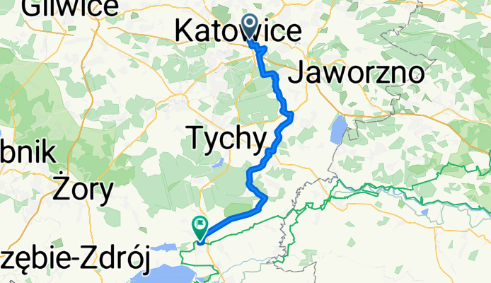
Road bike | Katowice - Pszczyna
Eine Fahrradroute, die in Katowice, Silesian Voivodeship, Poland beginnt.
Übersicht
Über diese Route
Route is always paved so you don't have to worry that you will damage your roadbike.
Quite a lot of traffic - these roads are rarely like quiet, smalltown paths, nevertheless this is a really good way to get to Pszczyna from Katowice with only road.
From Tychy's side, there is a problem with gravel paths around Kobiór, that's why you can't really cycle around there.
Route is tested by myself and corrected so you won't stuck in any one-way's
- -:--
- Dauer
- 49,1 km
- Distanz
- 149 m
- Aufstieg
- 164 m
- Abstieg
- ---
- Ø-Tempo
- ---
- Ø-Tempo

Routenqualität
Wegtypen und Untergründe entlang der Route
Wegtypen
Straße
18,5 km
(38 %)
Ruhige Straße
12,3 km
(25 %)
Untergründe
Befestigt
38,8 km
(79 %)
Asphalt
35,5 km
(72 %)
Pflastersteine
1,9 km
(4 %)
Weiter mit Bikemap
Diese Radroute verwenden, bearbeiten oder herunterladen
Du möchtest Road bike | Katowice - Pszczyna fahren oder sie für deine eigene Reise anpassen? Folgendes kannst du mit dieser Bikemap-Route machen:
Gratis Funktionen
- Speichere diese Route als Favorit oder in einer Sammlung
- Kopiere & plane deine eigene Version dieser Route
- Synchronisiere deine Route mit Garmin oder Wahoo
Premium-Funktionen
Kostenlose Testversion für 3 Tage oder einmalige Zahlung. Mehr über Bikemap Premium.
- Navigiere diese Route auf iOS & Android
- Exportiere eine GPX / KML-Datei dieser Route
- Erstelle deinen individuellen Ausdruck (Jetzt kostenlos ausprobieren)
- Lade diese Route für die Offline-Navigation herunter
Entdecke weitere Premium-Funktionen.
Bikemap Premium aktivierenVon unserer Community
Katowice: Andere beliebte Routen, die hier beginnen
 dwie hołdy
- Distanz
- 64,6 km
- Aufstieg
- 380 m
- Abstieg
- 382 m
- Standort
- Kattowitz, Woiwodschaft Schlesien, Polen
 Katowice-Chudów-Katowice
- Distanz
- 41,4 km
- Aufstieg
- 141 m
- Abstieg
- 138 m
- Standort
- Kattowitz, Woiwodschaft Schlesien, Polen
 Rekreacyjny Rajd Rowerowy Katowice
- Distanz
- 19,2 km
- Aufstieg
- 106 m
- Abstieg
- 109 m
- Standort
- Kattowitz, Woiwodschaft Schlesien, Polen
 Lasy panewnickie pętla
- Distanz
- 32,4 km
- Aufstieg
- 118 m
- Abstieg
- 119 m
- Standort
- Kattowitz, Woiwodschaft Schlesien, Polen
 Korea - 3 Stawy - Murcki - Wesoła Fala
- Distanz
- 27,6 km
- Aufstieg
- 198 m
- Abstieg
- 194 m
- Standort
- Kattowitz, Woiwodschaft Schlesien, Polen
 Etap z IC
- Distanz
- 61,1 km
- Aufstieg
- 260 m
- Abstieg
- 262 m
- Standort
- Kattowitz, Woiwodschaft Schlesien, Polen
 ZKSR2015
- Distanz
- 34,7 km
- Aufstieg
- 200 m
- Abstieg
- 200 m
- Standort
- Kattowitz, Woiwodschaft Schlesien, Polen
 Lengthy bike tour through Katowice
- Distanz
- 50,4 km
- Aufstieg
- 208 m
- Abstieg
- 205 m
- Standort
- Kattowitz, Woiwodschaft Schlesien, Polen
In der App öffnen