

To the Croda da Lago
Eine Fahrradroute, die in San Vito di Cadore, Veneto, Italy beginnt.
Übersicht
Über diese Route
Description from ”Mountain biking in the Dolomites” book (Mauro Tumler):
A 1600 m climb in the Dolomites is definitely not for everyone. The truth is, the starting point lies at just 1000 metres, but gaining altitude in the surroundings of Cortina can be challenging. In addition, this particular route uses a large section of the bicycle path built on the embankment on the old Cortina–Calalzo railway.
DIRECTIONS
This tour is not recommended without good riding skills and a high level of physical fitness. Weather conditions are also crucial. From campo di Sotto a steep climb on pavement leads to the Malga Federa. the Rifugio croda da Lago is reached following a short section of hike-a-bike. Here a great single-track section along the Via delle Dolomiti leads to the Forcella Ambrizzola and a difficult downhill section to the Rifugio città di Fiume, which is the most challenging part of this tour. the barely visible trail makes it hard to identify an ideal line. Although it would appear that the end of the excitement is in Val Forada, there remains a very technical single-track and an extremely steep downhill along forest road, to the Intrà les Aghes bridge, which usually takes riders by surprise.
Itinerary description
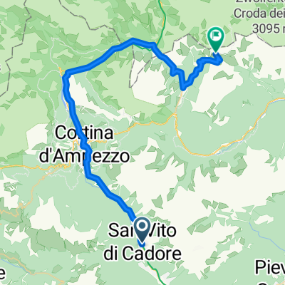
From S. Vito di cadore ➊ railway station (990 m) commence with a light climb along the bicycle lane toward cortina, via the ➋ Dogana Vecchia (1117 m). In Acquabona, get onto the main road for a short time and then back onto the bicycle path, up to the crossing in ➌ zuèl. Take a left, cross the bridge over the river Boite, and in ➍ campo di Sotto (1125 m) on paved road MtB route n. 8 (signposted), start climbing toward Monte Lungo; at the car park in ➎ Pianoze take a left and continue to ➏ Malga Federa (1816 m). From here there is a steep climb and a few hiking sections in order to reach the ➐ Rifugio croda da Lago (2064 m, food available). Following waymark n. 434 along a technical single-track to get to the ➑ Forcella Ambrizzola (2277 m). From the pass follow waymark n. 436 to S.Vito (very technical single-track) to Forcella col Duro and continue descending to the abandoned ➒ Malga Prendera (2148 m). Take waymark n. 458 (green arrow) and reach the ➓ Forcella Roan (1999 m). Continue descending, this time along waymark n. 467 (sign città di Fiume) to ⓫ Rifugio città di Fiume (1918 m, food available). there is a subsequent 60 vertical metres to get to the ⓬ Forcella Foràta (1977 m), then follow waymark n. 480 (S.Vito bike 4) and start a hard and technical downhill to the Intrà les Aghes ⓭ bridge (1379 m). on forest road n. 470/S.Vito, ride the steep section, cross the bridge toward ⓮ Soraunie and the ⓯ Sèrdes farmhouse (1000 m); from here continue along the road to ⓰ the Sèrdes bridge, cross it and bear to the left to arrive at the starting point, S.Vito.
STARTING POINT
San Vito di Cadore, 990 m
TARGET POINT
San Vito di Cadore, 990 m
- -:--
- Dauer
- 36,3 km
- Distanz
- 1.447 m
- Aufstieg
- 1.447 m
- Abstieg
- ---
- Ø-Tempo
- ---
- Ø-Tempo

Weiter mit Bikemap
Diese Radroute verwenden, bearbeiten oder herunterladen
Du möchtest To the Croda da Lago fahren oder sie für deine eigene Reise anpassen? Folgendes kannst du mit dieser Bikemap-Route machen:
Gratis Funktionen
- Speichere diese Route als Favorit oder in einer Sammlung
- Kopiere & plane deine eigene Version dieser Route
- Synchronisiere deine Route mit Garmin oder Wahoo
Premium-Funktionen
Kostenlose Testversion für 3 Tage oder einmalige Zahlung. Mehr über Bikemap Premium.
- Navigiere diese Route auf iOS & Android
- Exportiere eine GPX / KML-Datei dieser Route
- Erstelle deinen individuellen Ausdruck (Jetzt kostenlos ausprobieren)
- Lade diese Route für die Offline-Navigation herunter
Entdecke weitere Premium-Funktionen.
Bikemap Premium aktivierenVon unserer Community
San Vito di Cadore: Andere beliebte Routen, die hier beginnen
 Tour de Italia 2017 dzień 6
- Distanz
- 95,8 km
- Aufstieg
- 1.647 m
- Abstieg
- 2.428 m
- Standort
- San Vito di Cadore, Venetien, Italien
 Dolom3 (San Vito di Cadore – Stefansdorf - Bruneck)
- Distanz
- 84,8 km
- Aufstieg
- 1.174 m
- Abstieg
- 1.341 m
- Standort
- San Vito di Cadore, Venetien, Italien
 estate 2020 Tp4
- Distanz
- 64,5 km
- Aufstieg
- 192 m
- Abstieg
- 791 m
- Standort
- San Vito di Cadore, Venetien, Italien
 Passo Falzalegro / Valparola
- Distanz
- 58,9 km
- Aufstieg
- 1.264 m
- Abstieg
- 1.259 m
- Standort
- San Vito di Cadore, Venetien, Italien
 Lago Federa
- Distanz
- 35,8 km
- Aufstieg
- 1.195 m
- Abstieg
- 1.194 m
- Standort
- San Vito di Cadore, Venetien, Italien
 Dolom3_2 (San Vito di Cadore – Stefansdorf - Bruneck)
- Distanz
- 97,3 km
- Aufstieg
- 2.006 m
- Abstieg
- 2.172 m
- Standort
- San Vito di Cadore, Venetien, Italien
 5 Tori, Ref. Averau, passo Giau
- Distanz
- 61 km
- Aufstieg
- 1.664 m
- Abstieg
- 1.682 m
- Standort
- San Vito di Cadore, Venetien, Italien
 3 Zinnen ü. Schluderbach
- Distanz
- 42,6 km
- Aufstieg
- 1.481 m
- Abstieg
- 150 m
- Standort
- San Vito di Cadore, Venetien, Italien
In der App öffnen