east gate east to Fairborn
- 31 km
- 90 m
- 90 m
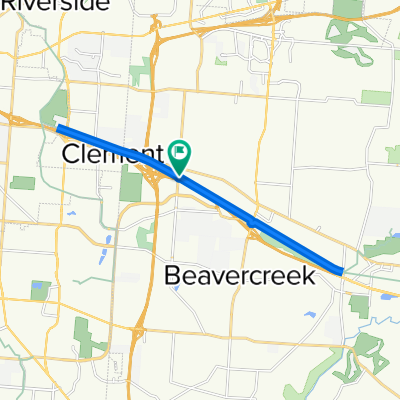
- Beavercreek, Ohio, Vereinigte Staaten
Eine Fahrradroute, die in Beavercreek, Ohio, Vereinigte Staaten beginnt.
Übersicht
Dies ist eine 64 Kilometer lange Route von der Arbeit nach Hause, die durch einige Hügel in Bellbrook führt, bevor sie nach Hause zurückkehrt. Rechts auf Factory Rechts auf Indian Ripple Links auf S. Alpha Bellbrook Links auf McBee (an Skyland) Links auf Upper Bellbrook Rechts auf Mead Rechts auf Stewart Rd Links auf Washington Mill Rd Links auf Lower Bellbrook Rd Rechts auf Schnebly Rd Rechts auf Richland Rd Links auf Simison Rd Rechts auf Schnebly Rd Links auf Bellbrook Ave Bellbrook St E Main St W Spring Valley Painters Rd. Links auf Elam Rd Links auf Richland Rd. Links auf Lower Bellbrook Rd Rechts auf Spahr Rd Links auf Washington Mill Rd. Rechts auf East Franklin St.
Erstellt vor 17 Jahren
Routenqualität
Straße
26,4 km
(44 %)
Ruhige Straße
18,6 km
(31 %)
Befestigt
1,2 km
(2 %)
Unbefestigt
0,6 km
(1 %)
Asphalt
1,2 km
(2 %)
Schotter
0,6 km
(1 %)
Undefiniert
58,3 km
(97 %)
Weiter mit Bikemap
Du möchtest RFW - Bellbrook Rolling Hills fahren oder sie für deine eigene Reise anpassen? Folgendes kannst du mit dieser Bikemap-Route machen:
Kostenlose Testversion für 3 Tage oder einmalige Zahlung. Mehr über Bikemap Premium.
Entdecke weitere Premium-Funktionen.
Bikemap Premium aktivierenVon unserer Community
In der App öffnen