
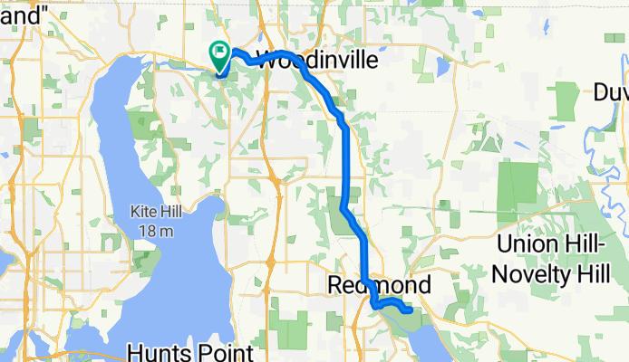
Red Brick Road Park to Marymoor Park
Eine Fahrradroute, die in Bothell, Washington, Vereinigte Staaten beginnt.
Übersicht
Über diese Route
- -:--
- Dauer
- 36,3 km
- Distanz
- 34 m
- Aufstieg
- 34 m
- Abstieg
- ---
- Ø-Tempo
- ---
- Max. Höhe
Routenqualität
Wegtypen und Untergründe entlang der Route
Wegtypen
Radweg
35,6 km
(98 %)
Ruhige Straße
0,7 km
(2 %)
Untergründe
Befestigt
36,3 km
(100 %)
Asphalt
35,6 km
(98 %)
Befestigt (undefiniert)
0,4 km
(1 %)
Beton
0,4 km
(1 %)
Weiter mit Bikemap
Diese Radroute verwenden, bearbeiten oder herunterladen
Du möchtest Red Brick Road Park to Marymoor Park fahren oder sie für deine eigene Reise anpassen? Folgendes kannst du mit dieser Bikemap-Route machen:
Gratis Funktionen
- Speichere diese Route als Favorit oder in einer Sammlung
- Kopiere & plane deine eigene Version dieser Route
- Synchronisiere deine Route mit Garmin oder Wahoo
Premium-Funktionen
Kostenlose Testversion für 3 Tage oder einmalige Zahlung. Mehr über Bikemap Premium.
- Navigiere diese Route auf iOS & Android
- Exportiere eine GPX / KML-Datei dieser Route
- Erstelle deinen individuellen Ausdruck (Jetzt kostenlos ausprobieren)
- Lade diese Route für die Offline-Navigation herunter
Entdecke weitere Premium-Funktionen.
Bikemap Premium aktivierenVon unserer Community
Bothell: Andere beliebte Routen, die hier beginnen
 Red Brick Road Park to Marymoor Park
- Distanz
- 36,3 km
- Aufstieg
- 34 m
- Abstieg
- 34 m
- Standort
- Bothell, Washington, Vereinigte Staaten
 Lake Washington Loop
- Distanz
- 90 km
- Aufstieg
- 309 m
- Abstieg
- 309 m
- Standort
- Bothell, Washington, Vereinigte Staaten
 Sammamish River Trail, Bothell to Sammamish River Trail, Bothell
- Distanz
- 20 km
- Aufstieg
- 1.695 m
- Abstieg
- 1.690 m
- Standort
- Bothell, Washington, Vereinigte Staaten
 24025 Bothell Everett Hwy, Bothell to 19220 Alderwood Mall Pkwy, Lynnwood
- Distanz
- 9,2 km
- Aufstieg
- 170 m
- Abstieg
- 110 m
- Standort
- Bothell, Washington, Vereinigte Staaten
 Bothell to Redmond
- Distanz
- 27,5 km
- Aufstieg
- 0 m
- Abstieg
- 3 m
- Standort
- Bothell, Washington, Vereinigte Staaten
 Main St, Bothell to NE 180th St, Bothell
- Distanz
- 20,8 km
- Aufstieg
- 44 m
- Abstieg
- 44 m
- Standort
- Bothell, Washington, Vereinigte Staaten
 10855–10899 E Riverside Dr, Bothell to 12316 134th Ct NE, Redmond
- Distanz
- 8,1 km
- Aufstieg
- 157 m
- Abstieg
- 131 m
- Standort
- Bothell, Washington, Vereinigte Staaten
 17865–17949 102nd Ave NE, Bothell to 17914–17948 102nd Ave NE, Bothell
- Distanz
- 31,8 km
- Aufstieg
- 0 m
- Abstieg
- 7 m
- Standort
- Bothell, Washington, Vereinigte Staaten
In der App öffnen