

Zaragoza to El Burgo de Ebro (actual)
Eine Fahrradroute, die in Zaragoza, Aragon, Spain beginnt.
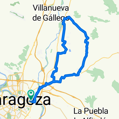
Übersicht
Über diese Route
Interesting landscape around the river. Some very rough stretches that are tough on our gravel bikes. Some kind of suspension would be good for this route. Note that the trip back is about 3 miles shorter as we did a lot of loops through the countryside. Note that there is a point about 7 or 8 miles along that loolis a little bit like three sides of a rectangle with the long side against the river and s small backtrack section on the northwest corner (I couldn't figure out a way to mark it in BikeMap). This is a place where we found a single-track hiking trail that was visible in sattlite photos but didn't show up in BikeMap. It took a bit of searching -- and had to just head across a meadow with no obvious trail but a park sign that was visible about 25 meters away. Anyway, it was a nice track to follow -- not technical, just narrow and poorly defined.
- 1 h 59 min
- Dauer
- 21,5 km
- Distanz
- 35 m
- Aufstieg
- 51 m
- Abstieg
- 10,8 km/h
- Ø-Tempo
- ---
- Ø-Tempo

Weiter mit Bikemap
Diese Radroute verwenden, bearbeiten oder herunterladen
Du möchtest Zaragoza to El Burgo de Ebro (actual) fahren oder sie für deine eigene Reise anpassen? Folgendes kannst du mit dieser Bikemap-Route machen:
Gratis Funktionen
- Speichere diese Route als Favorit oder in einer Sammlung
- Kopiere & plane deine eigene Version dieser Route
- Synchronisiere deine Route mit Garmin oder Wahoo
Premium-Funktionen
Kostenlose Testversion für 3 Tage oder einmalige Zahlung. Mehr über Bikemap Premium.
- Navigiere diese Route auf iOS & Android
- Exportiere eine GPX / KML-Datei dieser Route
- Erstelle deinen individuellen Ausdruck (Jetzt kostenlos ausprobieren)
- Lade diese Route für die Offline-Navigation herunter
Entdecke weitere Premium-Funktionen.
Bikemap Premium aktivierenVon unserer Community
Zaragoza: Andere beliebte Routen, die hier beginnen
 Almuerzo en Peñaflor
- Distanz
- 40 km
- Aufstieg
- 118 m
- Abstieg
- 116 m
- Standort
- Saragossa, Aragonien, Spanien
 cvcvcv
- Distanz
- 15,3 km
- Aufstieg
- 100 m
- Abstieg
- 104 m
- Standort
- Saragossa, Aragonien, Spanien
 Zaragoza to Lecinena loop (plan)
- Distanz
- 65,7 km
- Aufstieg
- 359 m
- Abstieg
- 351 m
- Standort
- Saragossa, Aragonien, Spanien
 Parque Tío Jorge - Anillo Verde - Parque Tío Jorge
- Distanz
- 31,9 km
- Aufstieg
- 128 m
- Abstieg
- 126 m
- Standort
- Saragossa, Aragonien, Spanien
 Villamayor - La Puebla de Alfinden
- Distanz
- 36,4 km
- Aufstieg
- 94 m
- Abstieg
- 94 m
- Standort
- Saragossa, Aragonien, Spanien
 Azud de Urdán
- Distanz
- 27 km
- Aufstieg
- 64 m
- Abstieg
- 66 m
- Standort
- Saragossa, Aragonien, Spanien
 Quick ride through Zaragoza
- Distanz
- 6,4 km
- Aufstieg
- 78 m
- Abstieg
- 78 m
- Standort
- Saragossa, Aragonien, Spanien
 5ª etapa Ebro 2002.
- Distanz
- 142,1 km
- Aufstieg
- 572 m
- Abstieg
- 718 m
- Standort
- Saragossa, Aragonien, Spanien
In der App öffnen