

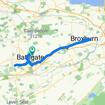
Bathgate Westfield loop
Eine Fahrradroute, die in Bathgate, Schottland, Vereinigtes Königreich beginnt.
Übersicht
Über diese Route
short introduction to hills on quiet roads
- -:--
- Dauer
- 16 km
- Distanz
- 168 m
- Aufstieg
- 155 m
- Abstieg
- ---
- Ø-Tempo
- ---
- Max. Höhe

Routenqualität
Wegtypen und Untergründe entlang der Route
Wegtypen
Ruhige Straße
3,7 km
(23 %)
Straße
0,6 km
(4 %)
Untergründe
Befestigt
4,8 km
(30 %)
Asphalt
4,8 km
(30 %)
Undefiniert
11,2 km
(70 %)
Weiter mit Bikemap
Diese Radroute verwenden, bearbeiten oder herunterladen
Du möchtest Bathgate Westfield loop fahren oder sie für deine eigene Reise anpassen? Folgendes kannst du mit dieser Bikemap-Route machen:
Gratis Funktionen
- Speichere diese Route als Favorit oder in einer Sammlung
- Kopiere & plane deine eigene Version dieser Route
- Synchronisiere deine Route mit Garmin oder Wahoo
Premium-Funktionen
Kostenlose Testversion für 3 Tage oder einmalige Zahlung. Mehr über Bikemap Premium.
- Navigiere diese Route auf iOS & Android
- Exportiere eine GPX / KML-Datei dieser Route
- Erstelle deinen individuellen Ausdruck (Jetzt kostenlos ausprobieren)
- Lade diese Route für die Offline-Navigation herunter
Entdecke weitere Premium-Funktionen.
Bikemap Premium aktivierenVon unserer Community
Bathgate: Andere beliebte Routen, die hier beginnen
 Bathgate to Asda Armadale to Broxburn to Bathgate 22.12.20
- Distanz
- 43,5 km
- Aufstieg
- 249 m
- Abstieg
- 251 m
- Standort
- Bathgate, Schottland, Vereinigtes Königreich
 Athol Terrace to Asda Armadale to East Mains Broxburn to Athol Terrace 24/4/21
- Distanz
- 47,6 km
- Aufstieg
- 329 m
- Abstieg
- 326 m
- Standort
- Bathgate, Schottland, Vereinigtes Königreich
 Leyland Road 408 to Jarvie Place 10
- Distanz
- 44,6 km
- Aufstieg
- 191 m
- Abstieg
- 322 m
- Standort
- Bathgate, Schottland, Vereinigtes Königreich
 Bathgate to Edinburgh
- Distanz
- 36 km
- Aufstieg
- 263 m
- Abstieg
- 371 m
- Standort
- Bathgate, Schottland, Vereinigtes Königreich
 Two beers
- Distanz
- 43,2 km
- Aufstieg
- 463 m
- Abstieg
- 464 m
- Standort
- Bathgate, Schottland, Vereinigtes Königreich
 Dobbies
- Distanz
- 29,2 km
- Aufstieg
- 147 m
- Abstieg
- 150 m
- Standort
- Bathgate, Schottland, Vereinigtes Königreich
 Dobbies 1
- Distanz
- 25,8 km
- Aufstieg
- 99 m
- Abstieg
- 131 m
- Standort
- Bathgate, Schottland, Vereinigtes Königreich
 Bathgate to Caldercruix to Bathgate 15/6/21
- Distanz
- 43,4 km
- Aufstieg
- 233 m
- Abstieg
- 214 m
- Standort
- Bathgate, Schottland, Vereinigtes Königreich
In der App öffnen