

B2B00503 55408 > 55455 via Greenway, LRT, Washington
Eine Fahrradroute, die in Minneapolis, Minnesota, United States of America beginnt.
Übersicht
Über diese Route
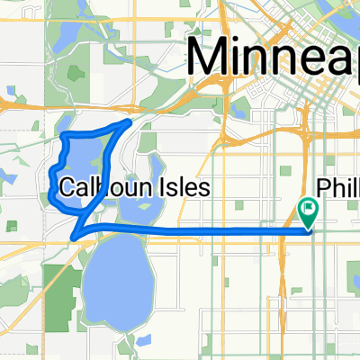
Head south on Bryant to the Greenway entrance ramp which is just south of 28th St. Take a left onto the Greenway, and head east. When you reach 28th Street/Hiawatha, take the bike bridge over Hiawatha. (Note: before you enter onto the bridge, you must cross 28th where cross traffic does not have a stop sign.) Once over the bridge, take a left to head north along the trail (alongside the Hiawathat Light Rail). When you reach the Cedar Riverside Station, take a right onto 15th, and a right onto 6th St. Take 6th St to 20th Ave, where you take a left and head into campus. 20th will end at 4th St, where you take a right, and a quick left onto the campus bike lane. Follow that north to the bike/pedestrian bridge (Washington) and follow over the River. Once on the East bank, veer right, around the curve which backtracks toward the river. Take the river road southeast for a few blocks to Harvard, and take a left to your destination.
- -:--
- Dauer
- 9,4 km
- Distanz
- 86 m
- Aufstieg
- 106 m
- Abstieg
- ---
- Ø-Tempo
- ---
- Ø-Tempo
Weiter mit Bikemap
Diese Radroute verwenden, bearbeiten oder herunterladen
Du möchtest B2B00503 55408 > 55455 via Greenway, LRT, Washington fahren oder sie für deine eigene Reise anpassen? Folgendes kannst du mit dieser Bikemap-Route machen:
Gratis Funktionen
- Speichere diese Route als Favorit oder in einer Sammlung
- Kopiere & plane deine eigene Version dieser Route
- Synchronisiere deine Route mit Garmin oder Wahoo
Premium-Funktionen
Kostenlose Testversion für 3 Tage oder einmalige Zahlung. Mehr über Bikemap Premium.
- Navigiere diese Route auf iOS & Android
- Exportiere eine GPX / KML-Datei dieser Route
- Erstelle deinen individuellen Ausdruck (Jetzt kostenlos ausprobieren)
- Lade diese Route für die Offline-Navigation herunter
Entdecke weitere Premium-Funktionen.
Bikemap Premium aktivierenVon unserer Community
Minneapolis: Andere beliebte Routen, die hier beginnen
 30 Miles
- Distanz
- 46,5 km
- Aufstieg
- 122 m
- Abstieg
- 142 m
- Standort
- Minneapolis, Minnesota, USA
 East/West River Ride
- Distanz
- 22,6 km
- Aufstieg
- 216 m
- Abstieg
- 217 m
- Standort
- Minneapolis, Minnesota, USA
 Easy ride in Minneapolis
- Distanz
- 13,1 km
- Aufstieg
- 448 m
- Abstieg
- 415 m
- Standort
- Minneapolis, Minnesota, USA
 34 Spruce Pl, Minneapolis to Loring Park, Minneapolis
- Distanz
- 15,3 km
- Aufstieg
- 62 m
- Abstieg
- 63 m
- Standort
- Minneapolis, Minnesota, USA
 S Sixth St, Minneapolis to Spruce Pl, Minneapolis
- Distanz
- 1,7 km
- Aufstieg
- 6 m
- Abstieg
- 21 m
- Standort
- Minneapolis, Minnesota, USA
 Out to Minnetonka and back
- Distanz
- 52 km
- Aufstieg
- 265 m
- Abstieg
- 264 m
- Standort
- Minneapolis, Minnesota, USA
 TCAC Cedar Lake Loop
- Distanz
- 15,9 km
- Aufstieg
- 55 m
- Abstieg
- 54 m
- Standort
- Minneapolis, Minnesota, USA
 1512 Spruce Pl, Minneapolis to 1512 Spruce Pl, Minneapolis
- Distanz
- 27,3 km
- Aufstieg
- 123 m
- Abstieg
- 123 m
- Standort
- Minneapolis, Minnesota, USA
In der App öffnen