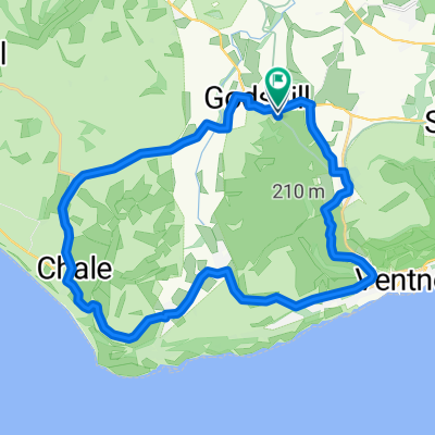
Chillerton Loop
- 28,6 km
- 291 m
- 290 m
- Ventnor, England, Vereinigtes Königreich
Eine Fahrradroute, die in Ventnor, England, Vereinigtes Königreich beginnt.
Übersicht
Ich genieße den gemächlichen Anstieg zum Aussichtspunkt Blackgang – auf diesem Abschnitt sehe ich oft Kolkraben. Heute hat mich ein sehr neugieriger Fasan vom Straßenrand aus beobachtet. Die besten Abfahrtsabschnitte: Von Upper Ventnor in die Undercliff, aber Achtung an der Kreuzung Gills Cliff Road & Castle Road (Ampel). Institute Hill, Niton (kurz, aber lohnend!). Vom Aussichtspunkt Blackgang nach Chale Street, schnell mit nur einem Kreisverkehr, und Berry Shute bis Highwood Lane, Chillerton. Um diese Runde auf über 20 Meilen zu verlängern, nimm kurz vor Rookley die Niton Road und schneide durch die Beacon Alley, die in die Whitwell Road zurück nach Godshill & Wroxall mündet. Viel Spaß.
Erstellt vor 5 Jahren
Routenqualität
Straße
22,4 km
46 %
Ruhige Straße
5,4 km
11 %
Befestigt
47,7 km
(98 %)
Asphalt
47,7 km
98 %
Undefiniert
1 km
2 %
Weiter mit Bikemap
Du möchtest Ravens Route 21.2 miles. fahren oder sie für deine eigene Reise anpassen? Folgendes kannst du mit dieser Bikemap-Route machen:
Kostenlose Testversion für 3 Tage oder einmalige Zahlung. Mehr über Bikemap Premium.
Entdecke weitere Premium-Funktionen.
Bikemap Premium aktivierenVon unserer Community
In der App öffnen