

Chillerton Tour - Via Whitwell & Roud
Eine Fahrradroute, die in Ventnor, England, United Kingdom beginnt.
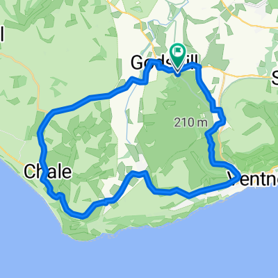
Übersicht
Über diese Route
Great classic, Sunday morning ride! Always lots of other riders to pass and say hi! 35km but only gentle climbs apart from Kingates Lane which is rather steep at the top, west end - look out for angry cars along the 'beautifully finished' Newport Road. A great drive along the Appleford Rd towards Chale then another short climb up Town Lane and into Emmett Hill. Stunning views always from Emmett Hill out toward the West Wight, Chillerton (notice the radio mast @ 1800 ft.) & Limmerstone. From Highwood Lane loop back to Rookley and the Chequers Inn, Niton Road > Southford Lane then back to the camp site at Wroxall. #wroxall #campsite #camping #isleofwightcycleroute #ventnor #appuldurcombe
- -:--
- Dauer
- 35,4 km
- Distanz
- 347 m
- Aufstieg
- 348 m
- Abstieg
- ---
- Ø-Tempo
- 136 m
- Ø-Tempo

Routenqualität
Wegtypen und Untergründe entlang der Route
Wegtypen
Straße
19,8 km
(56 %)
Vielbefahrene Straße
14,4 km
(41 %)
Untergründe
Befestigt
35,4 km
(100 %)
Asphalt
35,4 km
(100 %)
Weiter mit Bikemap
Diese Radroute verwenden, bearbeiten oder herunterladen
Du möchtest Chillerton Tour - Via Whitwell & Roud fahren oder sie für deine eigene Reise anpassen? Folgendes kannst du mit dieser Bikemap-Route machen:
Gratis Funktionen
- Speichere diese Route als Favorit oder in einer Sammlung
- Kopiere & plane deine eigene Version dieser Route
- Synchronisiere deine Route mit Garmin oder Wahoo
Premium-Funktionen
Kostenlose Testversion für 3 Tage oder einmalige Zahlung. Mehr über Bikemap Premium.
- Navigiere diese Route auf iOS & Android
- Exportiere eine GPX / KML-Datei dieser Route
- Erstelle deinen individuellen Ausdruck (Jetzt kostenlos ausprobieren)
- Lade diese Route für die Offline-Navigation herunter
Entdecke weitere Premium-Funktionen.
Bikemap Premium aktivierenVon unserer Community
Ventnor: Andere beliebte Routen, die hier beginnen
 Almost 20 mile loop
- Distanz
- 32,1 km
- Aufstieg
- 446 m
- Abstieg
- 444 m
- Standort
- Ventnor, England, Vereinigtes Königreich
 Wroxall Rookley Wroxall
- Distanz
- 22,4 km
- Aufstieg
- 207 m
- Abstieg
- 195 m
- Standort
- Ventnor, England, Vereinigtes Königreich
 Isle of Wight 109km
- Distanz
- 109 km
- Aufstieg
- 608 m
- Abstieg
- 608 m
- Standort
- Ventnor, England, Vereinigtes Königreich
 Alverstone Bombing Run
- Distanz
- 17,6 km
- Aufstieg
- 124 m
- Abstieg
- 122 m
- Standort
- Ventnor, England, Vereinigtes Königreich
 Chalk Ridge Extreme Route
- Distanz
- 93,2 km
- Aufstieg
- 1.115 m
- Abstieg
- 1.114 m
- Standort
- Ventnor, England, Vereinigtes Königreich
 Chillerton Tour - Via Whitwell & Roud
- Distanz
- 35,4 km
- Aufstieg
- 347 m
- Abstieg
- 348 m
- Standort
- Ventnor, England, Vereinigtes Königreich
 IOW 17 mile
- Distanz
- 25,6 km
- Aufstieg
- 252 m
- Abstieg
- 263 m
- Standort
- Ventnor, England, Vereinigtes Königreich
 Ravens Route 21.2 miles.
- Distanz
- 48,6 km
- Aufstieg
- 420 m
- Abstieg
- 428 m
- Standort
- Ventnor, England, Vereinigtes Königreich
In der App öffnen