
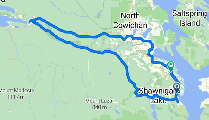
mill bay to cowichan lake
Eine Fahrradroute, die in North Saanich, British Columbia, Canada beginnt.
Übersicht
Über diese Route
Mill Bay Rd to Noowick (left) to Liggett (right) to Frayne (l) cross hwy to Lodgepole Rd. (r), to Deloume Rd. (r) cross hwy and parallel other side past Shawn-Mill Bay Rd onto Church Way to Kilmalu Rd (r) to Telegraph Rd.(l), past Cheeke and Wilder and Cherry Pt. and Cow. Bay Rd. to Koksilah Rd (r) then left, right, right, onto Cow Bay Rd. (watch for 1681 Cow. Bay Rd.)...to Jack Rd. (l) to Hillbank Rd. (r), back to Cow Bay Rd. (l), over river to Tzouhalem Rd. (r), to Quamichan Rd. East (l) and right onto Qwi'lus Lane and r back to Tzouhalem (l), to Valleyview Rd. (r), Sandra (l), Deborah (r), Frances (l) to Maple Bay Rd. (l), take right before roundabout, bringing you back to Tzouhalem, turn r on Jayne's Rd., to Lakes Rd. (l) to Beverly St. (r), onto Friendship Trail hairpin along TCH and back to Beverley (other side) onto Friendship Trail to roundabout Sherman Rd. (l), onto Transcanada Trail past Truesdale, which becomes Cowichan Valley Trail to Lk. Cow.
- -:--
- Dauer
- 116,3 km
- Distanz
- 586 m
- Aufstieg
- 564 m
- Abstieg
- ---
- Ø-Tempo
- ---
- Ø-Tempo
Routenqualität
Wegtypen und Untergründe entlang der Route
Wegtypen
Pfad
58,7 km
(51 %)
Straße
30,7 km
(26 %)
Untergründe
Befestigt
45,7 km
(39 %)
Unbefestigt
59,1 km
(51 %)
Schotter
59 km
(51 %)
Asphalt
35 km
(30 %)
Weiter mit Bikemap
Diese Radroute verwenden, bearbeiten oder herunterladen
Du möchtest mill bay to cowichan lake fahren oder sie für deine eigene Reise anpassen? Folgendes kannst du mit dieser Bikemap-Route machen:
Gratis Funktionen
- Speichere diese Route als Favorit oder in einer Sammlung
- Kopiere & plane deine eigene Version dieser Route
- Teile sie in Etappen ein, um eine mehrtägige Tour zu erstellen
- Synchronisiere deine Route mit Garmin oder Wahoo
Premium-Funktionen
Kostenlose Testversion für 3 Tage oder einmalige Zahlung. Mehr über Bikemap Premium.
- Navigiere diese Route auf iOS & Android
- Exportiere eine GPX / KML-Datei dieser Route
- Erstelle deinen individuellen Ausdruck (Jetzt kostenlos ausprobieren)
- Lade diese Route für die Offline-Navigation herunter
Entdecke weitere Premium-Funktionen.
Bikemap Premium aktivierenVon unserer Community
North Saanich: Andere beliebte Routen, die hier beginnen
 Mill Bay Loop
- Distanz
- 12,7 km
- Aufstieg
- 228 m
- Abstieg
- 230 m
- Standort
- North Saanich, British Columbia, Kanada
 Patricia Bay Highway 11300, Sidney to British Columbia 1 3140, Victoria
- Distanz
- 39,5 km
- Aufstieg
- 330 m
- Abstieg
- 318 m
- Standort
- North Saanich, British Columbia, Kanada
 Full Quad Trail Loop
- Distanz
- 28,7 km
- Aufstieg
- 607 m
- Abstieg
- 600 m
- Standort
- North Saanich, British Columbia, Kanada
 Ferry to Victoria
- Distanz
- 33,4 km
- Aufstieg
- 122 m
- Abstieg
- 122 m
- Standort
- North Saanich, British Columbia, Kanada
 Long ride from (null) to (null)
- Distanz
- 30,2 km
- Aufstieg
- 682 m
- Abstieg
- 679 m
- Standort
- North Saanich, British Columbia, Kanada
 Brentwood to Sidney
- Distanz
- 32,4 km
- Aufstieg
- 157 m
- Abstieg
- 157 m
- Standort
- North Saanich, British Columbia, Kanada
 Mill Bay - Cobble Hill Loop
- Distanz
- 26 km
- Aufstieg
- 273 m
- Abstieg
- 273 m
- Standort
- North Saanich, British Columbia, Kanada
 Top Of Old Mt Baldy
- Distanz
- 22,2 km
- Aufstieg
- 663 m
- Abstieg
- 659 m
- Standort
- North Saanich, British Columbia, Kanada
In der App öffnen