
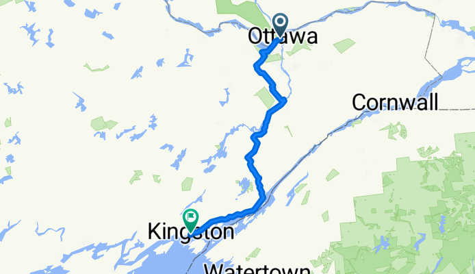
Ottawa to Kinhston (via Merrickville / Gananoque)
Eine Fahrradroute, die in Ottawa, Ontario, Canada beginnt.
Übersicht
Über diese Route
A fairly easy route from Ottawa to Kingston (via Merrickville, Athens, Gananogue). Relatively flat for most of the route, but there are a few good hills between Athens and the St-Lawrence Parkway. There are also a couple long hills between Gananogue and Kingston. Nevertheless, this route is still less hilly than others between Ottawa and Kingston. <br /><br />Except for a few crushed stone bicycle paths (which are suitable for road tires) between Ottawa and Stittsville, the entire route takes place on paved roads. Except for Highway 2 between Gananogue and Kingston, there are no paved shoulders on the roads for this route. However, most the roads are fairly quiet, and traffic should not be too much of an issue. There is a nice paved shoulder on highway 2. This route also make use of a bicycle path which runs along the St-Lawrence Parkway (and the 1000 Islands).
- -:--
- Dauer
- 213,9 km
- Distanz
- 367 m
- Aufstieg
- 331 m
- Abstieg
- ---
- Ø-Tempo
- 138 m
- Ø-Tempo
Routenqualität
Wegtypen und Untergründe entlang der Route
Wegtypen
Vielbefahrene Straße
110,2 km
(52 %)
Ruhige Straße
49,5 km
(23 %)
Untergründe
Befestigt
155,8 km
(73 %)
Unbefestigt
8,9 km
(4 %)
Asphalt
139 km
(65 %)
Befestigt (undefiniert)
14,3 km
(7 %)
Weiter mit Bikemap
Diese Radroute verwenden, bearbeiten oder herunterladen
Du möchtest Ottawa to Kinhston (via Merrickville / Gananoque) fahren oder sie für deine eigene Reise anpassen? Folgendes kannst du mit dieser Bikemap-Route machen:
Gratis Funktionen
- Speichere diese Route als Favorit oder in einer Sammlung
- Kopiere & plane deine eigene Version dieser Route
- Synchronisiere deine Route mit Garmin oder Wahoo
Premium-Funktionen
Kostenlose Testversion für 3 Tage oder einmalige Zahlung. Mehr über Bikemap Premium.
- Navigiere diese Route auf iOS & Android
- Exportiere eine GPX / KML-Datei dieser Route
- Erstelle deinen individuellen Ausdruck (Jetzt kostenlos ausprobieren)
- Lade diese Route für die Offline-Navigation herunter
Entdecke weitere Premium-Funktionen.
Bikemap Premium aktivierenVon unserer Community
Ottawa: Andere beliebte Routen, die hier beginnen
 Lac Leamy à Lac Pink
- Distanz
- 32,5 km
- Aufstieg
- 216 m
- Abstieg
- 217 m
- Standort
- Ottawa, Ontario, Kanada
 Italian Waters
- Distanz
- 12,7 km
- Aufstieg
- 54 m
- Abstieg
- 55 m
- Standort
- Ottawa, Ontario, Kanada
 Long Ride for Quickstart Autism
- Distanz
- 65,3 km
- Aufstieg
- 91 m
- Abstieg
- 83 m
- Standort
- Ottawa, Ontario, Kanada
 gat loop
- Distanz
- 48,5 km
- Aufstieg
- 398 m
- Abstieg
- 397 m
- Standort
- Ottawa, Ontario, Kanada
 Metcalfe St, Ottawa to Westboro Beach loop
- Distanz
- 23,8 km
- Aufstieg
- 285 m
- Abstieg
- 276 m
- Standort
- Ottawa, Ontario, Kanada
 Route to 373 Laurier Avenue East, Ottawa ON K1N 8X6
- Distanz
- 20,8 km
- Aufstieg
- 192 m
- Abstieg
- 190 m
- Standort
- Ottawa, Ontario, Kanada
 Hog's Back et Ferme expérimental
- Distanz
- 34,9 km
- Aufstieg
- 116 m
- Abstieg
- 116 m
- Standort
- Ottawa, Ontario, Kanada
 Route to Kichi Zībī Mīkan, Relais Kichi 27km
- Distanz
- 27,4 km
- Aufstieg
- 225 m
- Abstieg
- 223 m
- Standort
- Ottawa, Ontario, Kanada
In der App öffnen