

Nice route to the near villas and back to Blago
Eine Fahrradroute, die in Blagoewgrad, Blagoevgrad, Bulgarien beginnt.
Übersicht
Über diese Route
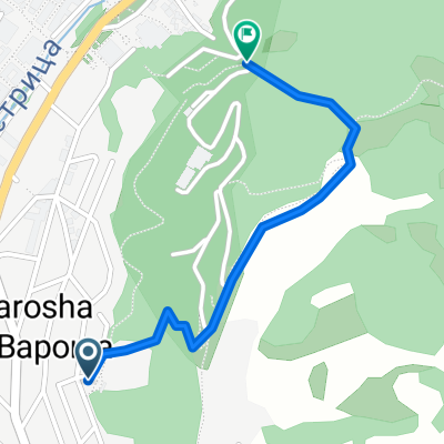
Nach dem Stadion ist die Straße sehr steil, aber wenn du gute Gänge hast und in Form bist, ist sie befahrbar, da sie asphaltiert ist. Wenn du den Gipfel des Hügels erreichst, wirst du ein seltsames, Area-51-ähnliches Gebäude (die Wasserversorgungsstation) sehen. Passiere es auf der linken Seite und gehe dann weiter nach oben. Bald wirst du einige Hütten und Gärten auf der rechten Seite sehen, auf der linken Seite einen schönen Wald. Fahre die Straße hinauf, dieser Abschnitt ist völlig abgelegen, also mach dir keine Sorgen, wild zu fahren - es gibt keine Autos. Irgendwann erreichst du eine staubige Kreuzung in der Nähe einiger Häuser, nimm die linke Abbiege und fahre durch das Dorf. Hüte dich vor den Hunden und genieße die Geschwindigkeit. Wieder sind die Autos ziemlich wenige, aber sei vorsichtig. Die Straße wird etwa zwei km vor Blago ziemlich kurvenreich - dort rate ich dir, langsamer zu werden und auf verrückte Fahrer zu achten. Es ist eine schöne Strecke - großartige Steigerung und Landschaftswechsel. Sichere Fahrt!
- -:--
- Dauer
- 9,4 km
- Distanz
- 243 m
- Aufstieg
- 213 m
- Abstieg
- ---
- Ø-Tempo
- ---
- Max. Höhe
Highlights der Route
POIs entlang der Route

Foto nach 0 km
Weiter mit Bikemap
Diese Radroute verwenden, bearbeiten oder herunterladen
Du möchtest Nice route to the near villas and back to Blago fahren oder sie für deine eigene Reise anpassen? Folgendes kannst du mit dieser Bikemap-Route machen:
Gratis Funktionen
- Speichere diese Route als Favorit oder in einer Sammlung
- Kopiere & plane deine eigene Version dieser Route
- Synchronisiere deine Route mit Garmin oder Wahoo
Premium-Funktionen
Kostenlose Testversion für 3 Tage oder einmalige Zahlung. Mehr über Bikemap Premium.
- Navigiere diese Route auf iOS & Android
- Exportiere eine GPX / KML-Datei dieser Route
- Erstelle deinen individuellen Ausdruck (Jetzt kostenlos ausprobieren)
- Lade diese Route für die Offline-Navigation herunter
Entdecke weitere Premium-Funktionen.
Bikemap Premium aktivierenVon unserer Community
Blagoewgrad: Andere beliebte Routen, die hier beginnen
 Razhodka okolo Blagoevgrad
- Distanz
- 20,7 km
- Aufstieg
- 424 m
- Abstieg
- 515 m
- Standort
- Blagoewgrad, Blagoevgrad, Bulgarien
 Dead end path with view on Bachinovo
- Distanz
- 1,1 km
- Aufstieg
- 100 m
- Abstieg
- 57 m
- Standort
- Blagoewgrad, Blagoevgrad, Bulgarien
 Blagoevgrad- Sapareva banya
- Distanz
- 50,3 km
- Aufstieg
- 1.160 m
- Abstieg
- 798 m
- Standort
- Blagoewgrad, Blagoevgrad, Bulgarien
 Scenic Route to Elenovo and back to Skapto
- Distanz
- 8,8 km
- Aufstieg
- 283 m
- Abstieg
- 303 m
- Standort
- Blagoewgrad, Blagoevgrad, Bulgarien
 Steep route to the almond forest
- Distanz
- 0,7 km
- Aufstieg
- 50 m
- Abstieg
- 29 m
- Standort
- Blagoewgrad, Blagoevgrad, Bulgarien
 Blagoevgrad-Demirevo-Bistrica-Blagoevgrad CLONED FROM ROUTE 819503
- Distanz
- 34 km
- Aufstieg
- 854 m
- Abstieg
- 858 m
- Standort
- Blagoewgrad, Blagoevgrad, Bulgarien
 Near the river (right side) to the lake
- Distanz
- 2 km
- Aufstieg
- 70 m
- Abstieg
- 26 m
- Standort
- Blagoewgrad, Blagoevgrad, Bulgarien
 Shortcut to/and the extreme downhill path
- Distanz
- 1,1 km
- Aufstieg
- 85 m
- Abstieg
- 75 m
- Standort
- Blagoewgrad, Blagoevgrad, Bulgarien
In der App öffnen