

Shortcut to/and the extreme downhill path
Eine Fahrradroute, die in Blagoewgrad, Blagoevgrad, Bulgarien beginnt.
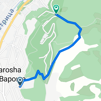
Übersicht
Über diese Route
Im Grunde fährst du die Nachbarschaft hinauf, an der linken Seite des Zoos vorbei, zum Rosengarten und dann den Hügel hinauf über die Antennen und die Straße entlang.
Wenn du die ersten Bäume erreichst, einen Ort, an dem die Fahrer über die Straße springen, siehst du links einen Stein, der mit roter Farbe bemalt ist. Auf dem gesamten Weg wirst du solche Steine sehen, die dir den Weg weisen. Ich empfehle dir jedoch beim ersten Mal, den Weg zu Fuß oder sehr langsam zu nehmen.
Nach der ersten Kurve geht der Weg steil bergab. Die Jungs haben einige wilde Sprünge, Seitentricks und alles, was zum Abfahrtfahren gehört, gebaut.
Da meine Fähigkeiten nicht sehr gut sind, habe ich die ganze Zeit gebremst, und trotzdem war es für mich ziemlich schwierig, auf dem Boden zu bleiben. Am Ende solltest du viel an den Seiten des Weges springen, um in Position zu bleiben. Es gibt auch einige ziemlich angsteinflößend hohe Sprünge.
Schau dir die Fotos auf der Karte an, um eine Vorstellung zu bekommen.
Benutze gute Ausrüstung und Schutz und schreie!
- -:--
- Dauer
- 1,1 km
- Distanz
- 85 m
- Aufstieg
- 75 m
- Abstieg
- ---
- Ø-Tempo
- ---
- Max. Höhe
Highlights der Route
POIs entlang der Route

Foto nach 0,5 km

Foto nach 0,8 km

Foto nach 0,8 km

Foto nach 0,8 km
Start of the DH path

Foto nach 0,8 km

Foto nach 0,9 km

Foto nach 0,9 km

Foto nach 0,9 km

Foto nach 0,9 km

Foto nach 0,9 km

Foto nach 1 km

Foto nach 1 km
Crazy part here

Foto nach 1 km
Very steep

Foto nach 1,1 km
Nice

Foto nach 1,1 km
The end
Weiter mit Bikemap
Diese Radroute verwenden, bearbeiten oder herunterladen
Du möchtest Shortcut to/and the extreme downhill path fahren oder sie für deine eigene Reise anpassen? Folgendes kannst du mit dieser Bikemap-Route machen:
Gratis Funktionen
- Speichere diese Route als Favorit oder in einer Sammlung
- Kopiere & plane deine eigene Version dieser Route
- Synchronisiere deine Route mit Garmin oder Wahoo
Premium-Funktionen
Kostenlose Testversion für 3 Tage oder einmalige Zahlung. Mehr über Bikemap Premium.
- Navigiere diese Route auf iOS & Android
- Exportiere eine GPX / KML-Datei dieser Route
- Erstelle deinen individuellen Ausdruck (Jetzt kostenlos ausprobieren)
- Lade diese Route für die Offline-Navigation herunter
Entdecke weitere Premium-Funktionen.
Bikemap Premium aktivierenVon unserer Community
Blagoewgrad: Andere beliebte Routen, die hier beginnen
 Nice route to the near villas and back to Blago
- Distanz
- 9,4 km
- Aufstieg
- 243 m
- Abstieg
- 213 m
- Standort
- Blagoewgrad, Blagoevgrad, Bulgarien
 Shortcut to/and the extreme downhill path
- Distanz
- 1,1 km
- Aufstieg
- 85 m
- Abstieg
- 75 m
- Standort
- Blagoewgrad, Blagoevgrad, Bulgarien
 Blagoevgrad- Sapareva banya
- Distanz
- 50,3 km
- Aufstieg
- 1.160 m
- Abstieg
- 798 m
- Standort
- Blagoewgrad, Blagoevgrad, Bulgarien
 Scenic Route to Elenovo and back to Skapto
- Distanz
- 8,8 km
- Aufstieg
- 283 m
- Abstieg
- 303 m
- Standort
- Blagoewgrad, Blagoevgrad, Bulgarien
 Blagoevgrad-Demirevo-Bistrica-Blagoevgrad CLONED FROM ROUTE 819503
- Distanz
- 34 km
- Aufstieg
- 854 m
- Abstieg
- 858 m
- Standort
- Blagoewgrad, Blagoevgrad, Bulgarien
 Blagoevgrad - Pehchevo
- Distanz
- 62,3 km
- Aufstieg
- 1.386 m
- Abstieg
- 731 m
- Standort
- Blagoewgrad, Blagoevgrad, Bulgarien
 Notre parcours en Macédoine
- Distanz
- 392,5 km
- Aufstieg
- 3.215 m
- Abstieg
- 2.575 m
- Standort
- Blagoewgrad, Blagoevgrad, Bulgarien
 Razhodka okolo Blagoevgrad
- Distanz
- 20,7 km
- Aufstieg
- 424 m
- Abstieg
- 515 m
- Standort
- Blagoewgrad, Blagoevgrad, Bulgarien
In der App öffnen