

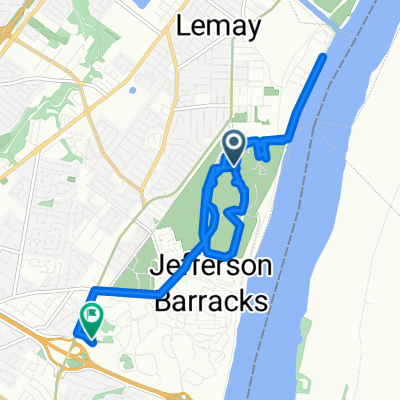
Grant's Trail - River Des Peres Greenway Connector
Eine Fahrradroute, die in Lemay, Missouri, USA beginnt.
Übersicht
Über diese Route
Although not shown on the map, this is a full loop. Grant's Trail does now extend east to the River Des Peres Greenway - it follows a route parallel to I-55.
Parking at any location is acceptable, but I personally suggest at the Grant's Trail Parking location at the Southern portion. The trail may also be accessed by the Metro, as the Shrewsbury line ends directly at the intersection of River Des Peres Blvd and Lansdowne Ave along the route.
I highly recommend stopping for food at either the Kirkwood Farmers Market (1 mile west on Argonne Dr.), downtown Webster Groves (on route), or downtown Maplewood (.5 mile north on Sutton Blvd.).
The trail can be started in either direction, although I recommend heading clockwise for the sake of being on the correct side of the road.
- -:--
- Dauer
- 35,8 km
- Distanz
- 167 m
- Aufstieg
- 166 m
- Abstieg
- ---
- Ø-Tempo
- ---
- Max. Höhe

Routenqualität
Wegtypen und Untergründe entlang der Route
Wegtypen
Radweg
25,7 km
(72 %)
Ruhige Straße
4,8 km
(13 %)
Untergründe
Befestigt
24 km
(67 %)
Asphalt
17,1 km
(48 %)
Befestigt (undefiniert)
6,8 km
(19 %)
Weiter mit Bikemap
Diese Radroute verwenden, bearbeiten oder herunterladen
Du möchtest Grant's Trail - River Des Peres Greenway Connector fahren oder sie für deine eigene Reise anpassen? Folgendes kannst du mit dieser Bikemap-Route machen:
Gratis Funktionen
- Speichere diese Route als Favorit oder in einer Sammlung
- Kopiere & plane deine eigene Version dieser Route
- Synchronisiere deine Route mit Garmin oder Wahoo
Premium-Funktionen
Kostenlose Testversion für 3 Tage oder einmalige Zahlung. Mehr über Bikemap Premium.
- Navigiere diese Route auf iOS & Android
- Exportiere eine GPX / KML-Datei dieser Route
- Erstelle deinen individuellen Ausdruck (Jetzt kostenlos ausprobieren)
- Lade diese Route für die Offline-Navigation herunter
Entdecke weitere Premium-Funktionen.
Bikemap Premium aktivierenVon unserer Community
Lemay: Andere beliebte Routen, die hier beginnen
 River City Casino Blvd, Saint Louis to 5328 Lode Ave, Saint Louis
- Distanz
- 8,7 km
- Aufstieg
- 77 m
- Abstieg
- 55 m
- Standort
- Lemay, Missouri, USA
 Recovered Route
- Distanz
- 14,6 km
- Aufstieg
- 115 m
- Abstieg
- 115 m
- Standort
- Lemay, Missouri, USA
 Grant's Trail - River Des Peres Greenway Connector
- Distanz
- 36,4 km
- Aufstieg
- 339 m
- Abstieg
- 337 m
- Standort
- Lemay, Missouri, USA
 Minnesota Avenue 6517, St. Louis to Leffingwell Avenue 360, Kirkwood
- Distanz
- 16,4 km
- Aufstieg
- 171 m
- Abstieg
- 124 m
- Standort
- Lemay, Missouri, USA
 Park to downtown
- Distanz
- 11,2 km
- Aufstieg
- 84 m
- Abstieg
- 90 m
- Standort
- Lemay, Missouri, USA
 Dover Pl, St. Louis to Dover Pl, St. Louis
- Distanz
- 10,6 km
- Aufstieg
- 82 m
- Abstieg
- 86 m
- Standort
- Lemay, Missouri, USA
 Grant's Trail - River Des Peres Greenway Connector
- Distanz
- 35,8 km
- Aufstieg
- 167 m
- Abstieg
- 166 m
- Standort
- Lemay, Missouri, USA
 5914 Leona St, St. Louis to 3948 Potomac St, St. Louis
- Distanz
- 3,8 km
- Aufstieg
- 31 m
- Abstieg
- 23 m
- Standort
- Lemay, Missouri, USA
In der App öffnen