
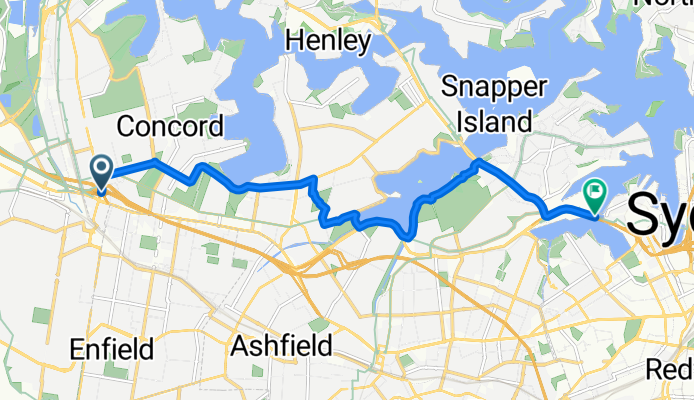
Alt. M4 to ANZAC Bridge
Eine Fahrradroute, die in Homebush, New South Wales, Australia beginnt.
Übersicht
Über diese Route
Alternative route from the beginning of the M4 to the ANZAC Bridge via Five Dock and Lilyfield. Longer but easier (and prettier) than the original (see http://www.bikemap.net/route/683128 for the original).
Avoids Gipps St/Queen St by taking Crane St/Lyons Rd instead. Usually quieter with fewer parked cars. The RTA has classified the road as "moderate difficulty on-road riding environment" but it's a pretty commonly used road by cyclists.
Avoids Lilyfield Rd by taking the scenic route along the Iron Cove Creek (also avoids the hill at Lilyfield Rd).
Once you reach Victoria Rd you have cycleways from there.
- -:--
- Dauer
- 11,6 km
- Distanz
- 115 m
- Aufstieg
- 144 m
- Abstieg
- ---
- Ø-Tempo
- ---
- Ø-Tempo
Weiter mit Bikemap
Diese Radroute verwenden, bearbeiten oder herunterladen
Du möchtest Alt. M4 to ANZAC Bridge fahren oder sie für deine eigene Reise anpassen? Folgendes kannst du mit dieser Bikemap-Route machen:
Gratis Funktionen
- Speichere diese Route als Favorit oder in einer Sammlung
- Kopiere & plane deine eigene Version dieser Route
- Synchronisiere deine Route mit Garmin oder Wahoo
Premium-Funktionen
Kostenlose Testversion für 3 Tage oder einmalige Zahlung. Mehr über Bikemap Premium.
- Navigiere diese Route auf iOS & Android
- Exportiere eine GPX / KML-Datei dieser Route
- Erstelle deinen individuellen Ausdruck (Jetzt kostenlos ausprobieren)
- Lade diese Route für die Offline-Navigation herunter
Entdecke weitere Premium-Funktionen.
Bikemap Premium aktivierenVon unserer Community
Homebush: Andere beliebte Routen, die hier beginnen
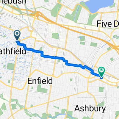
 Strathfield railway station to Marceau Drive 33, Concord
- Distanz
- 3,4 km
- Aufstieg
- 11 m
- Abstieg
- 29 m
- Standort
- Homebush, New South Wales, Australien
 M7 Full_
- Distanz
- 100,5 km
- Aufstieg
- 368 m
- Abstieg
- 365 m
- Standort
- Homebush, New South Wales, Australien
 69 Redmyre Road, Strathfield to 2 Knox Street, Ashfield
- Distanz
- 4,6 km
- Aufstieg
- 50 m
- Abstieg
- 50 m
- Standort
- Homebush, New South Wales, Australien
 Around Wentworth Point
- Distanz
- 25,5 km
- Aufstieg
- 159 m
- Abstieg
- 161 m
- Standort
- Homebush, New South Wales, Australien
 Parramatta Road 350, Homebush West to Parramatta
- Distanz
- 9,1 km
- Aufstieg
- 72 m
- Abstieg
- 74 m
- Standort
- Homebush, New South Wales, Australien
 Strathfield to City Farm via Prospect Reservoir
- Distanz
- 50,5 km
- Aufstieg
- 189 m
- Abstieg
- 165 m
- Standort
- Homebush, New South Wales, Australien
 Strathfield-Airport landing + take off
- Distanz
- 18,1 km
- Aufstieg
- 66 m
- Abstieg
- 77 m
- Standort
- Homebush, New South Wales, Australien
 Homebush to 44 Pomeroy St, Homebush
- Distanz
- 33,2 km
- Aufstieg
- 202 m
- Abstieg
- 200 m
- Standort
- Homebush, New South Wales, Australien
In der App öffnen