
T-649 Annual Bike HIke
Eine Fahrradroute, die in Julian, Kalifornien, Vereinigte Staaten beginnt.
Übersicht
Über diese Route
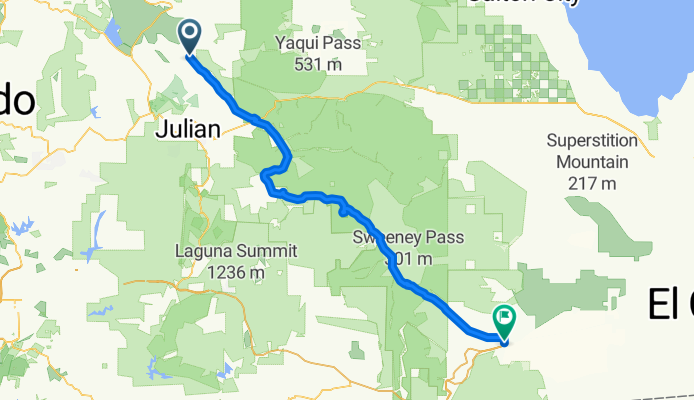
The members of BSA Troop 649 make this ride every January. Lunch the first day is at the Butterfield Stage Stop, and the first day's ride ends at Agua Caliente State Park. The next day, we ride to Ocotillo. Fun ride!!!
- -:--
- Dauer
- 96,4 km
- Distanz
- 343 m
- Aufstieg
- 1.300 m
- Abstieg
- ---
- Ø-Tempo
- ---
- Max. Höhe
Routenqualität
Wegtypen und Untergründe entlang der Route
Wegtypen
Vielbefahrene Straße
84,8 km
(88 %)
Ruhige Straße
4,6 km
(5 %)
Untergründe
Befestigt
86,4 km
(90 %)
Unbefestigt
3,7 km
(4 %)
Asphalt
86,3 km
(90 %)
Natürlicher Untergrund
3,4 km
(3 %)
Highlights der Route
POIs entlang der Route
Interessanter Ort nach 70,8 km
We gather here, and most put their bikes on the trailers and ride up the hill. Only the most dedicated (read "foolhardy") ride up the next hill!
Interessanter Ort nach 74,1 km
This is the toughest part of the ride. There's a steep up-hill climb, followed by a long up-hill climb! No Cubs are allowed to ride this portion, and most younger scouts are discouraged from riding it. The group gathers at the wash below the hill, and trucks and trailers are used to haul the riders and their bikes to a spot beyond the hill.
Interessanter Ort nach 78,8 km
This spot is where the riders re-mount their bikes and ride to the end.
Weiter mit Bikemap
Diese Radroute verwenden, bearbeiten oder herunterladen
Du möchtest T-649 Annual Bike HIke fahren oder sie für deine eigene Reise anpassen? Folgendes kannst du mit dieser Bikemap-Route machen:
Gratis Funktionen
- Speichere diese Route als Favorit oder in einer Sammlung
- Kopiere & plane deine eigene Version dieser Route
- Teile sie in Etappen ein, um eine mehrtägige Tour zu erstellen
- Synchronisiere deine Route mit Garmin oder Wahoo
Premium-Funktionen
Kostenlose Testversion für 3 Tage oder einmalige Zahlung. Mehr über Bikemap Premium.
- Navigiere diese Route auf iOS & Android
- Exportiere eine GPX / KML-Datei dieser Route
- Erstelle deinen individuellen Ausdruck (Jetzt kostenlos ausprobieren)
- Lade diese Route für die Offline-Navigation herunter
Entdecke weitere Premium-Funktionen.
Bikemap Premium aktivierenVon unserer Community
Julian: Andere beliebte Routen, die hier beginnen
 T-649 Annual Bike HIke
- Distanz
- 96,4 km
- Aufstieg
- 343 m
- Abstieg
- 1.300 m
- Standort
- Julian, Kalifornien, Vereinigte Staaten
 Julian Road 30218, Santa Ysabel to California 79 21979, Santa Ysabel
- Distanz
- 65,4 km
- Aufstieg
- 147 m
- Abstieg
- 676 m
- Standort
- Julian, Kalifornien, Vereinigte Staaten
 329-> JULIAN - TEMACULA
- Distanz
- 119 km
- Aufstieg
- 1.620 m
- Abstieg
- 2.593 m
- Standort
- Julian, Kalifornien, Vereinigte Staaten
 julian rad
- Distanz
- 27,4 km
- Aufstieg
- 462 m
- Abstieg
- 462 m
- Standort
- Julian, Kalifornien, Vereinigte Staaten
 Santa Isabel
- Distanz
- 72,2 km
- Aufstieg
- 992 m
- Abstieg
- 988 m
- Standort
- Julian, Kalifornien, Vereinigte Staaten
 4367 CA-78, Santa Ysabel to 12461–12499 Rancho Bernardo Rd, San Diego
- Distanz
- 56,6 km
- Aufstieg
- 524 m
- Abstieg
- 1.485 m
- Standort
- Julian, Kalifornien, Vereinigte Staaten
 Dudley's Bakery Sanfelipe 79
- Distanz
- 73 km
- Aufstieg
- 1.020 m
- Abstieg
- 1.020 m
- Standort
- Julian, Kalifornien, Vereinigte Staaten
 Coast to Crest
- Distanz
- 122,9 km
- Aufstieg
- 512 m
- Abstieg
- 1.779 m
- Standort
- Julian, Kalifornien, Vereinigte Staaten
In der App öffnen