

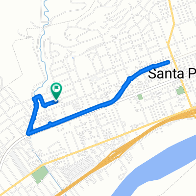
Balcom and Grimes Canyon Loop from Santa Paula
Eine Fahrradroute, die in Santa Paula, Kalifornien, Vereinigte Staaten beginnt.
Übersicht
Über diese Route
This loop incorporates the two paved roads crossing the mountain ridge between Santa Clara River Valley and the town of Moorpark in Southern California. I went counter-clockwise, taking the longer ascent of Balcom Canyon (southbound) with the longer descent of Grimes Canyon (northbound). The ascents were reasonable except for one brutal (~20%) section, while the descents were consistently gradual.
Grimes Canyon Rd had most cars on it, but it also had a generous shoulder in post places. (I read somewhere that on weekdays that road has many trucks on it hauling gravel from the nearby quarry.) Shoulder was not great on the rest of the route, but then traffic on it was lighter, too.
A lot of this route was part of the Santa Barbara to Santa Clarita stage in 2007 Tour of California. I realized why the Tour route went south all the way to Los Angeles Ave (aka route 118) - pavement on Stockton Road is consistently bad. Next time I would avoid it and take, e.g., Grimes Canyon Rd in its entirety.
- -:--
- Dauer
- 52,3 km
- Distanz
- 598 m
- Aufstieg
- 598 m
- Abstieg
- ---
- Ø-Tempo
- ---
- Max. Höhe
Routenqualität
Wegtypen und Untergründe entlang der Route
Wegtypen
Straße
28,3 km
(54 %)
Ruhige Straße
15,7 km
(30 %)
Undefiniert
8,4 km
(16 %)
Untergründe
Befestigt
5,2 km
(10 %)
Asphalt
4,7 km
(9 %)
Beton
0,5 km
(1 %)
Undefiniert
47,1 km
(90 %)
Weiter mit Bikemap
Diese Radroute verwenden, bearbeiten oder herunterladen
Du möchtest Balcom and Grimes Canyon Loop from Santa Paula fahren oder sie für deine eigene Reise anpassen? Folgendes kannst du mit dieser Bikemap-Route machen:
Gratis Funktionen
- Speichere diese Route als Favorit oder in einer Sammlung
- Kopiere & plane deine eigene Version dieser Route
- Synchronisiere deine Route mit Garmin oder Wahoo
Premium-Funktionen
Kostenlose Testversion für 3 Tage oder einmalige Zahlung. Mehr über Bikemap Premium.
- Navigiere diese Route auf iOS & Android
- Exportiere eine GPX / KML-Datei dieser Route
- Erstelle deinen individuellen Ausdruck (Jetzt kostenlos ausprobieren)
- Lade diese Route für die Offline-Navigation herunter
Entdecke weitere Premium-Funktionen.
Bikemap Premium aktivierenVon unserer Community
Santa Paula: Andere beliebte Routen, die hier beginnen
 santa paula to ojai
- Distanz
- 32,1 km
- Aufstieg
- 218 m
- Abstieg
- 231 m
- Standort
- Santa Paula, Kalifornien, Vereinigte Staaten
 Santa Paula to Camulos
- Distanz
- 41 km
- Aufstieg
- 207 m
- Abstieg
- 70 m
- Standort
- Santa Paula, Kalifornien, Vereinigte Staaten
 Community-Senior Center, Santa Paula to Acacia Road 450, Santa Paula
- Distanz
- 5,5 km
- Aufstieg
- 4 m
- Abstieg
- 14 m
- Standort
- Santa Paula, Kalifornien, Vereinigte Staaten
 Santa Paula to Goleta via Ojai
- Distanz
- 98,7 km
- Aufstieg
- 744 m
- Abstieg
- 820 m
- Standort
- Santa Paula, Kalifornien, Vereinigte Staaten
 West Telegraph Road 15887, Santa Paula to Acacia Road 450, Santa Paula
- Distanz
- 10,8 km
- Aufstieg
- 25 m
- Abstieg
- 27 m
- Standort
- Santa Paula, Kalifornien, Vereinigte Staaten
 208 Eliot St, Santa Paula to 209 Eliot St, Santa Paula
- Distanz
- 5,8 km
- Aufstieg
- 16 m
- Abstieg
- 14 m
- Standort
- Santa Paula, Kalifornien, Vereinigte Staaten
 Santa Paula to Ventura County
- Distanz
- 21,1 km
- Aufstieg
- 108 m
- Abstieg
- 118 m
- Standort
- Santa Paula, Kalifornien, Vereinigte Staaten
 422 Dartmouth Rd, Santa Paula to 306 E Main St, Santa Paula
- Distanz
- 2,5 km
- Aufstieg
- 10 m
- Abstieg
- 3 m
- Standort
- Santa Paula, Kalifornien, Vereinigte Staaten
In der App öffnen