
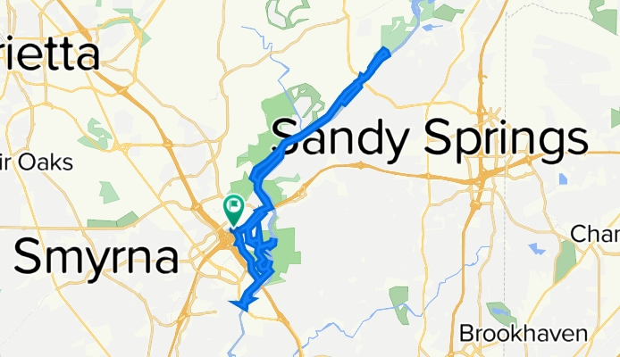
Four Parks-Paces Mill-West Palisades-Cochran Shoals-Johnson Ferry
Eine Fahrradroute, die in Vinings, Georgia, Vereinigte Staaten beginnt.
Übersicht
Über diese Route
Dies ist eine schöne Route, einige sind Radwege (derzeit nicht am 12. Oktober auf Google Maps abgebildet). Einige sind Wanderwege. Ich benutze mein Trekkingrad. Ich denke, für Rennräder ist es nicht geeignet, es sei denn, man schiebt sein Fahrrad.
Die Columns Dr SE ist besonders malerisch, da man sehr reiche Häuser mit riesigen Grundstücken sehen kann. Eine Art Paläste.
Man kann darüber nachdenken, es als malerische Fahrt zu betrachten. Ich mag diese Route sehr.
Sie können einige Orte besuchen in
Chattahoochee River National Recreation Area Karte:
- Paces Mill
- West Palisades
- Cochran Shoals
- Johnson Ferry
- -:--
- Dauer
- 32,4 km
- Distanz
- 303 m
- Aufstieg
- 304 m
- Abstieg
- ---
- Ø-Tempo
- ---
- Max. Höhe
Weiter mit Bikemap
Diese Radroute verwenden, bearbeiten oder herunterladen
Du möchtest Four Parks-Paces Mill-West Palisades-Cochran Shoals-Johnson Ferry fahren oder sie für deine eigene Reise anpassen? Folgendes kannst du mit dieser Bikemap-Route machen:
Gratis Funktionen
- Speichere diese Route als Favorit oder in einer Sammlung
- Kopiere & plane deine eigene Version dieser Route
- Synchronisiere deine Route mit Garmin oder Wahoo
Premium-Funktionen
Kostenlose Testversion für 3 Tage oder einmalige Zahlung. Mehr über Bikemap Premium.
- Navigiere diese Route auf iOS & Android
- Exportiere eine GPX / KML-Datei dieser Route
- Erstelle deinen individuellen Ausdruck (Jetzt kostenlos ausprobieren)
- Lade diese Route für die Offline-Navigation herunter
Entdecke weitere Premium-Funktionen.
Bikemap Premium aktivierenVon unserer Community
Vinings: Andere beliebte Routen, die hier beginnen
 Vinings Loop
- Distanz
- 34,6 km
- Aufstieg
- 352 m
- Abstieg
- 352 m
- Standort
- Vinings, Georgia, Vereinigte Staaten
 Marietta to Marietta
- Distanz
- 7,8 km
- Aufstieg
- 183 m
- Abstieg
- 121 m
- Standort
- Vinings, Georgia, Vereinigte Staaten
 chat feb 10
- Distanz
- 14,4 km
- Aufstieg
- 144 m
- Abstieg
- 158 m
- Standort
- Vinings, Georgia, Vereinigte Staaten
 SE of Atlanta 258 km vikend
- Distanz
- 268 km
- Aufstieg
- 613 m
- Abstieg
- 602 m
- Standort
- Vinings, Georgia, Vereinigte Staaten
 hill route
- Distanz
- 22,2 km
- Aufstieg
- 365 m
- Abstieg
- 365 m
- Standort
- Vinings, Georgia, Vereinigte Staaten
 ATL2STL4
- Distanz
- 1.137,1 km
- Aufstieg
- 1.521 m
- Abstieg
- 1.652 m
- Standort
- Vinings, Georgia, Vereinigte Staaten
 Four Parks-Paces Mill-West Palisades-Cochran Shoals-Johnson Ferry
- Distanz
- 32,4 km
- Aufstieg
- 303 m
- Abstieg
- 304 m
- Standort
- Vinings, Georgia, Vereinigte Staaten
 BTB Day1
- Distanz
- 128,5 km
- Aufstieg
- 598 m
- Abstieg
- 385 m
- Standort
- Vinings, Georgia, Vereinigte Staaten
In der App öffnen