

B2B00497 55106>55082 via Bruce Vento Trl, Gateway Trl, Myrtle Av
- 28,4 km
- 92 m
- 89 m
- Maplewood, Minnesota, Vereinigte Staaten
Eine Fahrradroute, die in Maplewood, Minnesota, Vereinigte Staaten beginnt.
Übersicht
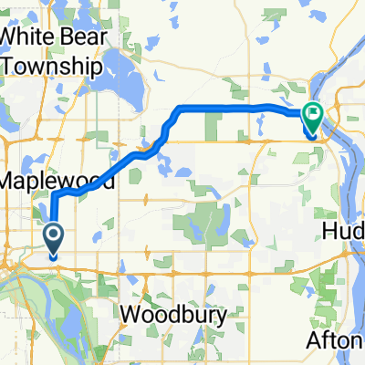
Nehmen Sie die Upper Afton nach Westen bis zur Ruth. Biegen Sie rechts ab und folgen Sie der Ruth bis zur Minnehaha. Biegen Sie an der Minnehaha links ab und fahren Sie weiter zur Johnson Parkway. Biegen Sie an der Johnson Parkway rechts ab und fahren Sie zur Lake Phalen. Halten Sie sich links auf die Wheelock Parkway. Fahren Sie auf der Wheelock Parkway über die Hwy. 61 und weiter zur Edgerton Street. Biegen Sie rechts auf Edgerton ab. Folgen Sie Edgerton nach Norden, vorbei an Larpenteur und über die Highway 36. Vorbei an Gervais Lake auf Ihrer rechten Seite und über 694 zur Vadnais Lake Blvd. Biegen Sie links ab und folgen Sie der Vadnais Lake Blvd. rund um den See, bis Sie zur Rice Street kommen. Biegen Sie rechts auf die Rice Street ab und fahren Sie weiter nach Norden auf der Rice bis zur Gramsie Rd. Oben auf dem großen Hügel biegen Sie rechts auf die Victoria ab. Nehmen Sie die Victoria zur County Rd. F und biegen Sie links ab. Folgen Sie Cty. F zur Lexington und biegen Sie links ab. Fahren Sie nach Süden auf der Lexington zu 4001 und zu Ihrem Ziel.
Routenqualität
Straße
17,6 km
65 %
Radweg
3,8 km
14 %
Befestigt
11,7 km
(43 %)
Asphalt
10,6 km
39 %
Beton
1,1 km
4 %
Undefiniert
15,5 km
57 %
Highlights der Route
You can take the road through the lake at this point to County Rd. F and then left to Gramsie and Rice. THe gate is not open during the late fall and winter.
Weiter mit Bikemap
Du möchtest B2B00784 55125>55164 via Up.Afton/Ruth/Mhaha/JohnsonPkwy/Wheelock/Edgerton/VadLake/Rice/Gramsie/Lex fahren oder sie für deine eigene Reise anpassen? Folgendes kannst du mit dieser Bikemap-Route machen:
Kostenlose Testversion für 3 Tage oder einmalige Zahlung. Mehr über Bikemap Premium.
Entdecke weitere Premium-Funktionen.
Bikemap Premium aktivierenVon unserer Community
In der App öffnen


