

Castro Marim Touring Tour
Eine Fahrradroute, die in Castro Marim, Faro, Portugal beginnt.
Übersicht
Über diese Route
EN:
About the route
Start and finish of the route: Castro Marim (next to the Town Hall)
Difficulty level: Intermediate
Time needed: Approximately 3h at an average of 12.5 km/h
Elevation: Climb of 527 m, 527 m descent
GPS Coordinates: 37.21741, -7.44338
Distance: 37 km
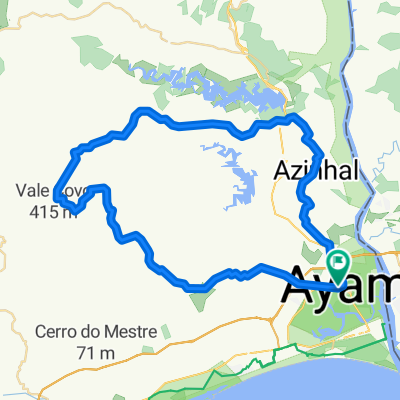
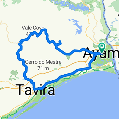
Description
The route head northwards out of Castro Marim is challenging but the scenery is beautiful. Be sure to stop on the Cerro do Enho (Enho Hill) and drink in the fabulous 360º view over the eastern Algarve. Ride downhill towards the Beliche Dam and keep going through Portela Alta de Cima before joining the old EN 122 national road through the typical village of Azinhal. Before arriving back in Castro Marim, you will also pass through the villages of Junqueira and Monte Francisco.
PT:
Sobre a Rota:
Início e fim do percurso – Castro Marim – junto à CM Castro Marim
Grau/nível de dificuldade - Intermédio
Tempo de duração – Aproximadamente 3h00 à média de cerca de 12,5km/h
Altimetria – 490mt de subida
Coordenadas GPS: 37.21741, -7.44338
Distância: 37.3km
Saindo de Castro Marim para norte do concelho, pedale por um percurso desafiante mas de enorme beleza. Em Cerro do Enho aproveite para desfrutar da paisagem 360º sobre o sotavento algarvio. Desça para a barragem do Beliche e continue pela Portela Alta de Cima. Irá vislumbrar a imponente barragem do Beliche, seguindo depois pela antiga EN122 que passa pela típica aldeia o Azinhal. Antes de chegar a Castro Marim irá ainda encontrar as localidades de Junqueira e Monte Francisco.
ES:
Sobre la ruta
Inicio y final del recorrido: Castro Marim (junto a la Cámara Municipal)
Nivel de dificultad: medio
Duración: Unas 3 horas a una media aproximada de 12,5 km/h
Altimetría:
527 metros de ascensión
527 metros descenso
Coordenadas GPS: 37.21741, -7.44338
Distancia: 37 kilómetros
Descripción
Salimos de Castro Marim hacia el norte del municipio, y pedaleamos a lo largo de un trayecto desafiante, pero de enorme belleza. En el cerro de Enho, podemos aprovechar para disfrutar de unas vistas panorámicas de 360º sobre el Sotavento del Algarve. Descendemos hasta el embalse de Beliche, y continuamos por Portela Alta de Cima antes de llegar a la antigua EN122, que pasa por la aldea típica de Azinhal. Antes de llegar a Castro Marim, todavía nos encontraremos las localidades de Junqueira y Monte Francisco.
- -:--
- Dauer
- 38,4 km
- Distanz
- 530 m
- Aufstieg
- 532 m
- Abstieg
- ---
- Ø-Tempo
- ---
- Max. Höhe

Routenqualität
Wegtypen und Untergründe entlang der Route
Wegtypen
Straße
17,2 km
(45 %)
Vielbefahrene Straße
16,3 km
(42 %)
Untergründe
Befestigt
12,2 km
(32 %)
Asphalt
12,2 km
(32 %)
Undefiniert
26,2 km
(68 %)
Weiter mit Bikemap
Diese Radroute verwenden, bearbeiten oder herunterladen
Du möchtest Castro Marim Touring Tour fahren oder sie für deine eigene Reise anpassen? Folgendes kannst du mit dieser Bikemap-Route machen:
Gratis Funktionen
- Speichere diese Route als Favorit oder in einer Sammlung
- Kopiere & plane deine eigene Version dieser Route
- Synchronisiere deine Route mit Garmin oder Wahoo
Premium-Funktionen
Kostenlose Testversion für 3 Tage oder einmalige Zahlung. Mehr über Bikemap Premium.
- Navigiere diese Route auf iOS & Android
- Exportiere eine GPX / KML-Datei dieser Route
- Erstelle deinen individuellen Ausdruck (Jetzt kostenlos ausprobieren)
- Lade diese Route für die Offline-Navigation herunter
Entdecke weitere Premium-Funktionen.
Bikemap Premium aktivierenVon unserer Community
Castro Marim: Andere beliebte Routen, die hier beginnen
 Route to Castro Marim
- Distanz
- 31,9 km
- Aufstieg
- 506 m
- Abstieg
- 482 m
- Standort
- Castro Marim, Faro, Portugal
 Catrso Marim por Algarve interior 03-01-13
- Distanz
- 63,3 km
- Aufstieg
- 696 m
- Abstieg
- 695 m
- Standort
- Castro Marim, Faro, Portugal
 Interior Algarve-Castro Marim-Bekice Alto-Tavira-CastroMarim
- Distanz
- 78,9 km
- Aufstieg
- 767 m
- Abstieg
- 764 m
- Standort
- Castro Marim, Faro, Portugal
 Interior Algarve-Castro Marim-Belisse Alto-Tavira-Castro Marim
- Distanz
- 78,9 km
- Aufstieg
- 0 m
- Abstieg
- 0 m
- Standort
- Castro Marim, Faro, Portugal
 castor marin - alcarias ( 102 km - 1750)
- Distanz
- 102,4 km
- Aufstieg
- 1.055 m
- Abstieg
- 1.053 m
- Standort
- Castro Marim, Faro, Portugal
 Barragem_Beliche_OLH_Super
- Distanz
- 69,9 km
- Aufstieg
- 752 m
- Abstieg
- 792 m
- Standort
- Castro Marim, Faro, Portugal
 Alcoutim
- Distanz
- 19,7 km
- Aufstieg
- 228 m
- Abstieg
- 294 m
- Standort
- Castro Marim, Faro, Portugal
 VUELTA POR SIERRA CASTRO MARIN
- Distanz
- 61,6 km
- Aufstieg
- 779 m
- Abstieg
- 781 m
- Standort
- Castro Marim, Faro, Portugal
In der App öffnen