

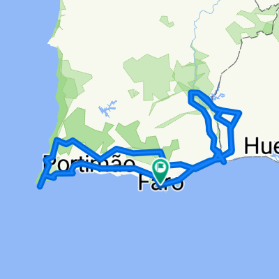
Faro Touring Tour
Eine Fahrradroute, die in Faro, Faro, Portugal beginnt.
Übersicht
Über diese Route
EN:
About the route
• Start and finish of the route: Faro (Praça Dom Francisco Gomes)
• Difficulty level: Easy
• Time needed: Approximately 3h00mins at an average of 12 km/h
• Elevation: Climb 386 m, 386 descent
• GPS Coordinates: 37.01614, -7.93537
• Distance: 38 km
Description
From the pleasure harbour in the city centre, start by riding through Faro’s historical old town. Once you reach the outskirts of the city the route takes you into the inland part of the municipality, through the village of Conceição and, farther on, Estoi. There are several interesting places to visit in Estoi, such as Ossónoba Square, located in the oldest part of town, the Estoi Palace Pousada, the Main Church and the ruins of the Milreu Roman Villa. As you go around the Guelhim Hill, you will encounter the little village of Santa Bárbara de Nexe, with its impressive Main Church.
The ride back to the capital of the municipality is mainly downhill and on flat terrain, taking you through the woodland area of Ludo.
PT:
Sobre a rota
Início e fim do percurso – Faro - Praça Dom Francisco Gomes
Grau/nível de dificuldade - Fácil
Tempo de duração – Aproximadamente 3h00 à média de cerca de 12,5km/h
Altimetria – 320mt de subida
Coordenadas GPS: 37.01614, -7.93537
Distância: 37.9km
Da doca de recreio de Faro, bem na baixa da cidade inicie a pedalada pelo centro histórico da cidade. Contornando a cidade, o percurso segue depois para o interior do concelho passando pela aldeia da Conceição e mais adiante por Estoi. Esta última oferece vários pontos de interesse que poderá visitar como o Largo Ossónoba, a Pousada do Palácio de Estoi, a Igreja Matriz ou as ruínas romanas do Milreu. Contornando o cerro do Guilhim, irá encontrar a pequena aldeia de Santa Bárbara de Nexe.
O retorno à capital do concelho é feito maioritariamente em descida e terreno plano passando pela área florestal do Ludo.
ES:
Sobre la ruta
• Inicio y final de la ruta: Faro (Praça Dom Francisco Gomes)
• Nivel de dificultad: Fácil
• Duración: Unas 3 horas a una media aproximada de 12,5 km/h
• Altimetría:
386 metros de ascensión
386 metros descenso
Coordenadas GPS: 37.01614, -7.93537
Distancia: 38 kilómetros
Descripción
La ruta parte del puerto deportivo de Faro hacia el centro histórico de la ciudad. Rodea el núcleo urbano y continúa hacia el interior del municipio, pasando por la aldea de Conceição y por Estoi. Esta última localidad cuenta con varios lugares de interés, como la plaza Ossónoba, ubicada en el núcleo residencial más antiguo, la posada del Palacio de Estoi, la iglesia matriz y las ruinas de la villa romana de Milreu. Bordeando el cerro de Guelhim, encontrará la pequeña aldea de Santa Bárbara de Nexe y su imponente iglesia matriz.
El regreso a la capital del municipio transcurre casi en su totalidad en bajada y terreno plano, y pasa por la zona forestal de Ludo.
- -:--
- Dauer
- 38 km
- Distanz
- 393 m
- Aufstieg
- 393 m
- Abstieg
- ---
- Ø-Tempo
- ---
- Ø-Tempo

Routenqualität
Wegtypen und Untergründe entlang der Route
Wegtypen
Ruhige Straße
16,4 km
(43 %)
Straße
12,8 km
(34 %)
Untergründe
Befestigt
7 km
(18 %)
Unbefestigt
6,3 km
(17 %)
Asphalt
7 km
(18 %)
Schotter
3,8 km
(10 %)
Highlights der Route
POIs entlang der Route

Interessanter Ort nach 0,2 km
Arco da Vila

Interessanter Ort nach 0,4 km
Sé de Faro
Interessanter Ort nach 9,9 km
Conceição de Faro
Interessanter Ort nach 15,2 km
Palácio de Estoi
Interessanter Ort nach 15,5 km
Igreja Matriz de Estoi
Interessanter Ort nach 16,4 km
Ruínas Romanas de Milreu
Interessanter Ort nach 24,1 km
Santa Bárbara de Nexe
Interessanter Ort nach 26,4 km
Estádio do Algarve
Interessanter Ort nach 30 km
Zona florestal do Ludo

Interessanter Ort nach 36,4 km
Parque Ribeirinho
Weiter mit Bikemap
Diese Radroute verwenden, bearbeiten oder herunterladen
Du möchtest Faro Touring Tour fahren oder sie für deine eigene Reise anpassen? Folgendes kannst du mit dieser Bikemap-Route machen:
Gratis Funktionen
- Speichere diese Route als Favorit oder in einer Sammlung
- Kopiere & plane deine eigene Version dieser Route
- Synchronisiere deine Route mit Garmin oder Wahoo
Premium-Funktionen
Kostenlose Testversion für 3 Tage oder einmalige Zahlung. Mehr über Bikemap Premium.
- Navigiere diese Route auf iOS & Android
- Exportiere eine GPX / KML-Datei dieser Route
- Erstelle deinen individuellen Ausdruck (Jetzt kostenlos ausprobieren)
- Lade diese Route für die Offline-Navigation herunter
Entdecke weitere Premium-Funktionen.
Bikemap Premium aktivierenVon unserer Community
Faro: Andere beliebte Routen, die hier beginnen
 Girolibero: Algarve
- Distanz
- 688,9 km
- Aufstieg
- 9.003 m
- Abstieg
- 8.976 m
- Standort
- Faro, Faro, Portugal
 Faro_Lisbonne_porto-Saint Jacques de Compostelle
- Distanz
- 944,4 km
- Aufstieg
- 1.352 m
- Abstieg
- 1.117 m
- Standort
- Faro, Faro, Portugal
 Soulfulbikes to Garrão
- Distanz
- 18 km
- Aufstieg
- 3 m
- Abstieg
- 17 m
- Standort
- Faro, Faro, Portugal
 Portugal
- Distanz
- 861,2 km
- Aufstieg
- 1.226 m
- Abstieg
- 1.232 m
- Standort
- Faro, Faro, Portugal
 2009-05-16 - Ecovia Algarve (Vila Real de Santo Antonio-Faro)
- Distanz
- 72,8 km
- Aufstieg
- 172 m
- Abstieg
- 170 m
- Standort
- Faro, Faro, Portugal
 De Rua Coronel António Santos Fonseca 8, Faro a EM525 9, Loulé
- Distanz
- 27,8 km
- Aufstieg
- 153 m
- Abstieg
- 312 m
- Standort
- Faro, Faro, Portugal
 Faro - Albufeira
- Distanz
- 46 km
- Aufstieg
- 211 m
- Abstieg
- 171 m
- Standort
- Faro, Faro, Portugal
 Faro Quarteira
- Distanz
- 26,4 km
- Aufstieg
- 99 m
- Abstieg
- 100 m
- Standort
- Faro, Faro, Portugal
In der App öffnen