

Lagoa Touring Tour
Eine Fahrradroute, die in Lagoa, Faro, Portugal beginnt.
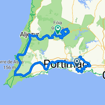
Übersicht
Über diese Route
EN:
About the route
• Start and finish of the route: Lagoa (Municipal Auditorium)
• Difficulty level: Intermediate
• Time needed: Approximately 3h 15mins at an average of 12.5 km/h
• Elevation: 488 m climb, 485 m descent
• GPS Coordinates: 37.13699, -8.45795
• Distance: 42.1 km
Description
There are various places of interest along the Lagoa route. Setting out from Lagoa city centre, ride in a south-easterly direction until you reach the coast and the charming Benagil Beach. If you can, be sure to visit the famous Algar de Benagil sinkhole. The terrain here is very up-and-down because of the cliffs. Although short, the uphill and downhill sections here are quite steep, so you do need to be a capable rider. Continuing along the coast in a westerly direction you will pass through the town of Carvoeiro and then Ferragudo. Stop off to explore both of them and admire their attractive silhouettes rising against the background of the seashore. Heading northwards now, you will come to the town of Estômbar and, farther on, a park called Parque das Fontes. Nature lovers are very fond of this spot where you can go diving, have a picnic or simply enjoy a few moments of convivial rest and relaxation.
PT:
Sobre a Rota:
Início e fim do percurso – Lagoa - Auditório Municipal
Grau/nível de dificuldade - Fácil
Tempo de duração – Aproximadamente 3h15 à média de cerca de 12,5km/h
Altimetria – 350mt de subida
Coordenadas GPS: 37.13699, -8.45795
Distância: 42.1km
O percurso de Lagoa apresenta variados pontos de interesse ao longo do percurso. Saindo do centro da cidade de Lagoa pedale para sudeste até chegar à costa e à encantadora praia de Benagil. Não deixe de visitar o famoso Algar de Benagil. Encontra-se numa zona de falésias e como tal o terreno é bastante acidentado. As subidas e descidas, apesar de curtas são bastante íngremes e requerem alguma destreza e experiência. Continuando junto à costa para oeste, irá passar pelo Carvoeiro e depois por Ferragudo. Ambas oferecem vários pontos de interesse a visitar. Seguindo para norte irá passar por Estômbar e mais adiante irá encontrar o Parque das fontes, antes de regressar a Lagoa.
ES:
Sobre la ruta
• Inicio y final de la ruta: Lagoa (auditorio municipal)
• Nivel de dificultad: medio
• Duración: Unas 3 horas y 15 minutos a una media aproximada de 12,5 km/h
• Altimetría:
488 metros de ascensión
485 metros descenso
• Coordenadas GPS: 37.13699, -8.45795
Descripción
La ruta de Lagoa nos lleva por numerosos lugares de interés. Partiendo del centro de Lagoa, pedalee hacia el sudeste hasta llegar a la costa y la hermosa playa de Benagil. Si tiene oportunidad, visite su famosa cueva. Se encuentra en uno de los acantilados, por lo que el terreno es muy escarpado. Los ascensos y descensos, a pesar de ser breves, son bastante acusados y requieren cierta destreza y experiencia. Continúe por la costa en dirección oeste. Pasará por el pueblo de Carvoeiro, y después por Ferragudo. Deténgase a conocerlos y a contemplar de la belleza de estas siluetas recortadas junto al mar. Siguiendo hacia el norte, encontrará el pueblo de Estômbar y, más adelante, el Parque de las Fuentes, muy apreciado por los amantes de la naturaleza, en donde podrá darse un chapuzón, disfrutar de un pícnic al aire libre o simplemente pasar un buen rato charlando y descansando.
- -:--
- Dauer
- 42,3 km
- Distanz
- 488 m
- Aufstieg
- 485 m
- Abstieg
- ---
- Ø-Tempo
- ---
- Ø-Tempo

Routenqualität
Wegtypen und Untergründe entlang der Route
Wegtypen
Straße
20,8 km
(49 %)
Ruhige Straße
16,6 km
(39 %)
Untergründe
Befestigt
8,6 km
(20 %)
Unbefestigt
4,8 km
(11 %)
Asphalt
8,5 km
(20 %)
Unbefestigt (undefiniert)
2 km
(5 %)
Weiter mit Bikemap
Diese Radroute verwenden, bearbeiten oder herunterladen
Du möchtest Lagoa Touring Tour fahren oder sie für deine eigene Reise anpassen? Folgendes kannst du mit dieser Bikemap-Route machen:
Gratis Funktionen
- Speichere diese Route als Favorit oder in einer Sammlung
- Kopiere & plane deine eigene Version dieser Route
- Synchronisiere deine Route mit Garmin oder Wahoo
Premium-Funktionen
Kostenlose Testversion für 3 Tage oder einmalige Zahlung. Mehr über Bikemap Premium.
- Navigiere diese Route auf iOS & Android
- Exportiere eine GPX / KML-Datei dieser Route
- Erstelle deinen individuellen Ausdruck (Jetzt kostenlos ausprobieren)
- Lade diese Route für die Offline-Navigation herunter
Entdecke weitere Premium-Funktionen.
Bikemap Premium aktivierenVon unserer Community
Lagoa: Andere beliebte Routen, die hier beginnen
 etapa 2
- Distanz
- 190,1 km
- Aufstieg
- 1.814 m
- Abstieg
- 958 m
- Standort
- Lagoa, Faro, Portugal
 litoral
- Distanz
- 49,4 km
- Aufstieg
- 367 m
- Abstieg
- 396 m
- Standort
- Lagoa, Faro, Portugal
 Deutschland - Portugal (Berlin - Faro) PT 25 Lagoa - Olhos de Água
- Distanz
- 32 km
- Aufstieg
- 309 m
- Abstieg
- 384 m
- Standort
- Lagoa, Faro, Portugal
 caminho - 20.08
- Distanz
- 78,4 km
- Aufstieg
- 375 m
- Abstieg
- 341 m
- Standort
- Lagoa, Faro, Portugal
 #14 Lagoa Nível 1
- Distanz
- 61,8 km
- Aufstieg
- 596 m
- Abstieg
- 594 m
- Standort
- Lagoa, Faro, Portugal
 Lagoa-Silves MTB
- Distanz
- 43,3 km
- Aufstieg
- 411 m
- Abstieg
- 412 m
- Standort
- Lagoa, Faro, Portugal
 Monchique
- Distanz
- 118,6 km
- Aufstieg
- 1.144 m
- Abstieg
- 1.143 m
- Standort
- Lagoa, Faro, Portugal
 stage 3
- Distanz
- 19,6 km
- Aufstieg
- 206 m
- Abstieg
- 164 m
- Standort
- Lagoa, Faro, Portugal
In der App öffnen