

Around Mount Warning
Eine Fahrradroute, die in Murwillumbah, New South Wales, Australien beginnt.
Übersicht
Über diese Route
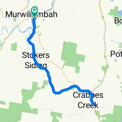
Wir starten in Uki und fahren nach Osten und dann nach Norden entlang der Kyogle Road, die dem Tweed River folgt. Nach etwa 10 km biegen wir links in die Tyalgum Road ab, die dem Oxley River folgt. Wir halten in Tyalgum für eine Teepause. Danach fahren wir nach Süden auf der Brays Creek Road. Bei 33 km biegen wir links in die Byrrill Creek Road ab. Wir steigen stetig durch Buschland auf einer unbefestigten Straße an. Am 38-km-Punkt beginnen wir abzusteigen und erhaschen Blicke auf den Byrrill Creek rechts und den Mount Warning links von uns. Bei 49,8 km biegen wir links in die Kyogle Road ein, der wir bis Uki folgen. Mittagessen in Uki im Park oder im Café oder Pub.
- -:--
- Dauer
- 56,2 km
- Distanz
- 808 m
- Aufstieg
- 806 m
- Abstieg
- ---
- Ø-Tempo
- ---
- Max. Höhe

Weiter mit Bikemap
Diese Radroute verwenden, bearbeiten oder herunterladen
Du möchtest Around Mount Warning fahren oder sie für deine eigene Reise anpassen? Folgendes kannst du mit dieser Bikemap-Route machen:
Gratis Funktionen
- Speichere diese Route als Favorit oder in einer Sammlung
- Kopiere & plane deine eigene Version dieser Route
- Synchronisiere deine Route mit Garmin oder Wahoo
Premium-Funktionen
Kostenlose Testversion für 3 Tage oder einmalige Zahlung. Mehr über Bikemap Premium.
- Navigiere diese Route auf iOS & Android
- Exportiere eine GPX / KML-Datei dieser Route
- Erstelle deinen individuellen Ausdruck (Jetzt kostenlos ausprobieren)
- Lade diese Route für die Offline-Navigation herunter
Entdecke weitere Premium-Funktionen.
Bikemap Premium aktivierenVon unserer Community
Murwillumbah: Andere beliebte Routen, die hier beginnen
 18 Murwillumbah YHA to Mt Warning, round
- Distanz
- 66,5 km
- Aufstieg
- 443 m
- Abstieg
- 445 m
- Standort
- Murwillumbah, New South Wales, Australien
 Murwillimbah to Kyogle
- Distanz
- 78,7 km
- Aufstieg
- 1.614 m
- Abstieg
- 1.555 m
- Standort
- Murwillumbah, New South Wales, Australien
 Numb bah Rd To B Rd
- Distanz
- 12,4 km
- Aufstieg
- 91 m
- Abstieg
- 94 m
- Standort
- Murwillumbah, New South Wales, Australien
 Day 4 Murwillimbah - Aspley
- Distanz
- 182,1 km
- Aufstieg
- 1.125 m
- Abstieg
- 1.089 m
- Standort
- Murwillumbah, New South Wales, Australien
 maybe
maybe- Distanz
- 56,6 km
- Aufstieg
- 446 m
- Abstieg
- 446 m
- Standort
- Murwillumbah, New South Wales, Australien
 Nullum St, Murwillumbah to 1 Broadway La, Burringbar
- Distanz
- 20,5 km
- Aufstieg
- 374 m
- Abstieg
- 366 m
- Standort
- Murwillumbah, New South Wales, Australien
 Recovered Route
- Distanz
- 48,5 km
- Aufstieg
- 375 m
- Abstieg
- 375 m
- Standort
- Murwillumbah, New South Wales, Australien
 Around Mount Warning
- Distanz
- 56,2 km
- Aufstieg
- 808 m
- Abstieg
- 806 m
- Standort
- Murwillumbah, New South Wales, Australien
In der App öffnen