History Tour - Route 1
Eine Fahrradroute, die in Redford, Michigan, Vereinigte Staaten beginnt.
Übersicht
Über diese Route
Slow Roll Bike Tour. This route can also be driven or walked as well.
- -:--
- Dauer
- 6,8 km
- Distanz
- 5 m
- Aufstieg
- 6 m
- Abstieg
- ---
- Ø-Tempo
- ---
- Max. Höhe
Routenqualität
Wegtypen und Untergründe entlang der Route
Wegtypen
Ruhige Straße
4,9 km
(72 %)
Zufahrtsstraße
0,1 km
(2 %)
Undefiniert
1,8 km
(26 %)
Highlights der Route
POIs entlang der Route

Interessanter Ort nach 0 km
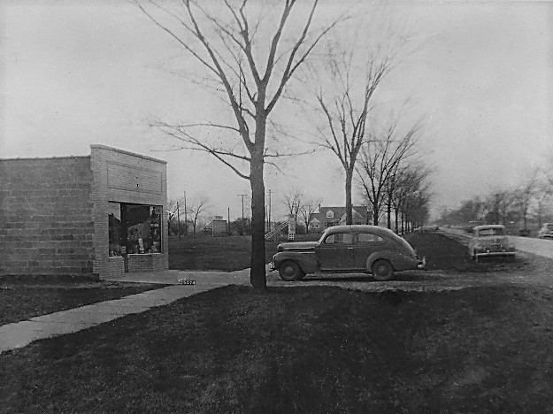
Originally built in 1946 as an ice-cream shop, it later became DesAutels Paint Store from 1950-1962. It stood alone until 1969 when the adjacent building was added on. It has been owned and operated by the Murphy family since 1983.

Interessanter Ort nach 0,3 km
The Zink House was built in 1939 by Julius Zink. It was the home of his wife, Muriel Zink, who became the first Chairperson for the Redford Township Historical Commission in 1969. Before the Historical Commission and Historical Society began meeting at the Little Red School House, they would often have meetings at the Zink House. The adjacent office building was home to Zink Insurance Agency from the 1940s through the 70s . What's more, Julius Zink was the insurer for the Redford Township Board of Trustees for over 20 years.

Interessanter Ort nach 0,8 km
The Wait House is the oldest known house in Redford Township. It was built by Luther Wait approximately in 1824 on the southside of 5 Mile Road and served as the first clubhouse for Western Golf Club. Eventually the golf club outgrew the farmhouse and it was then moved to 5 Mile and Gaylord around 1927. The home was donated to Redford Township in 2008 by the family of its last owners.

Interessanter Ort nach 0,9 km
Bell Creek Park is named for the first settlers of Redford, Israel and Laura Bell, who journeyed up the Rouge River in 1818 before settling around the area now known as Pomona Drive. In fact, the Five Mile/Telegraph area was once referred to as Bell Branch, and the Redford Cemetery was also called Bell Branch after the Bell family.

Interessanter Ort nach 2 km
Western Golf & Country Club began construction in 1926 on farmland that was once a part of the Burt Farm (owned by George W. Burt). The golf club opened in 1927. It became a private country club in 1945 and continues to be so to this day.

Interessanter Ort nach 2 km
"Kingsboro Castle" was built in 1929. It was originally designed by George Miller (MillerStorm Co.) as part of BE Taylor's planned Kingsboro District which enveloped the area from Western Golf Club to Lake Como. There was a Kingsboro Canoe Club and riding stables as well. Lake Como was later filled in around the mid 1950s.

Interessanter Ort nach 3,5 km
George W. Ferrington House. This historic home is one of the oldest in Redford Township. GW Ferrington was the 6th man to settle in Redford c.1829. He was Redford's first Supervisor, serving many times between the 1830's and 1850. He passed away in 1854 at the age of 59.

Interessanter Ort nach 3,8 km
"The Pump House" was a red brick building used by the Wayne County Sewage System until the middle Rouge drain was built. Around 1958 it was sold to an individual with the hopes of converting the pump house into a livable dwelling. In 1969 construction began on the new "House on Stilts." Since the pump house was built on one of the lowest points in the Township, the area was prone to floods.
Interessanter Ort nach 4,4 km
Once the site of Roosevelt Elementary School built in 1926, it was originally named Leanne School and then Hettie Bristol before finally Roosevelt. It was demolished in 2012 after having been closed since 2006. At the time, there was talk about turning the land into a Historic District, but after the Little Red Schoolhouse on Beech Daly was demolished, those plans faded away. Today, the land is owned by the Township and remains a green space.

Interessanter Ort nach 4,8 km
In the 1920s Arthur Aubry (yes, the street name is named after him) had a small confectionary store at this corner before opening a barber shop across the street. Throughout the 50s and 60s, this building was home to Bodker Dairy Company who supplied milk to schools throughout Redford. Bodker Dairy declared bankruptcy in 1971. The building was then later purchased by the Ring Bros.

Interessanter Ort nach 4,9 km
In the 1950s this building was home to The Redford Observer and the Law Offices of Romaine C. Rice (one of the founders of the Detroit Free Press and a Justice of the Peace for Redford). Soon after, it became a hall for the D.A.V. post 113 in the 1960s.

Interessanter Ort nach 5,2 km
From 1956 until 1962 the Redford Library was housed in this building. Plans for a larger library began right away with the accumulation of so many books. In 1962 the library was moved into a larger building behind Town Hall (where the Marquee is today) and became the most popular library in all of Wayne County at that time.

Interessanter Ort nach 5,2 km
In 1969 the Redford Township Court was relocated from its 6 Mile location to this brick building with two court rooms, one for each of Redford's judges; Robert Brang and John Dillon. Due to the limited parking, visitors were told to park across the street at Town Hall. In 1977, plans began on building a new and larger court across the street near Town Hall and the police/fire departments.

Interessanter Ort nach 5,6 km
The 17th District Court was located across the street from Town Hall until 1977 when building began at the current address next to the Redford Fire Station. It was completed in 1978. In 2018 construction/remodeling began which expanded the size of the court house and opted for a more modern appearance.

Interessanter Ort nach 5,6 km
This location of Redford's Town Hall and attached Fire Department was dedicated c.1941. Town Hall and the Fire Department Garage were expanded in 1953.

Interessanter Ort nach 5,6 km
Redford Town Hall moved from a small building on 7 mile and Norborne to its current location around 1942. It expanded in 1953 with minor renovations taking place in 1956 and continuing throughout the late 60s. The clerks office was added on in 1974. In 1983, to celebrate the 150th anniversary of Redford, Town Hall was renovated to include a main entrance off of Beech Daly, a clock tower, and old fashioned pillars.

Interessanter Ort nach 5,7 km
After being housed in the fire hall for a number of years, the Redford Library was housed at the corner of 5 Mile and Beech in a small building next to the gas station from 1949 until 1956. In 1956, the library was moved down the street right across from Town Hall.

Interessanter Ort nach 6,5 km
The township purchased the vacant 1/4 acre of property in 1966, originally intending it as a possible site for a new courthouse. In 1967, the Redford Community War Memorial Association proposed a memorial building on the site to commemorate the heroes of WWI and WWII. By 1973, plans were underway to develop the land into a park for the community. Also known as Monument Park or Civic Memorial Park. Veterans Memorial Park was upgraded in 2011 to include a granite memorial bench and marker for MIAs and POWs.

Interessanter Ort nach 6,7 km
In 1961 the Department of Public Works garage was converted into the Redford Police Station. Prior to that, the police and fire departments shared a building on 7 Mile next to the old Town Hall building. The construction of the police station was completed in 1962. In 1990-91 the police station was torn down and rebuilt to be bigger and better. Construction was completed in 1992.

Interessanter Ort nach 6,7 km
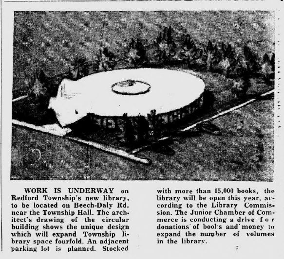
Before Redford's Marquee (Market) this building was the Redford Library. It was dedicated on May 20th, 1962. In 1966, an additional 4,000 square feet was added onto the northwest corner. This library location was abandoned in 2004 when a new, larger library was built on 6 Mile road. It reopened as the Marquee in 2008.
Weiter mit Bikemap
Diese Radroute verwenden, bearbeiten oder herunterladen
Du möchtest History Tour - Route 1 fahren oder sie für deine eigene Reise anpassen? Folgendes kannst du mit dieser Bikemap-Route machen:
Gratis Funktionen
- Speichere diese Route als Favorit oder in einer Sammlung
- Kopiere & plane deine eigene Version dieser Route
- Synchronisiere deine Route mit Garmin oder Wahoo
Premium-Funktionen
Kostenlose Testversion für 3 Tage oder einmalige Zahlung. Mehr über Bikemap Premium.
- Navigiere diese Route auf iOS & Android
- Exportiere eine GPX / KML-Datei dieser Route
- Erstelle deinen individuellen Ausdruck (Jetzt kostenlos ausprobieren)
- Lade diese Route für die Offline-Navigation herunter
Entdecke weitere Premium-Funktionen.
Bikemap Premium aktivierenVon unserer Community
Redford: Andere beliebte Routen, die hier beginnen
 17329 Louise St, Livonia to 17329 Louise St, Livonia
- Distanz
- 7,2 km
- Aufstieg
- 20 m
- Abstieg
- 19 m
- Standort
- Redford, Michigan, Vereinigte Staaten
 Melissa’s
- Distanz
- 4,5 km
- Aufstieg
- 13 m
- Abstieg
- 13 m
- Standort
- Redford, Michigan, Vereinigte Staaten
 17329 Louise St, Livonia to 17329 Louise St, Livonia
- Distanz
- 8,5 km
- Aufstieg
- 13 m
- Abstieg
- 13 m
- Standort
- Redford, Michigan, Vereinigte Staaten
 9209 Nathaline, Redford to 26801–26899 Westfield Ave, Redford
- Distanz
- 9,9 km
- Aufstieg
- 7 m
- Abstieg
- 6 m
- Standort
- Redford, Michigan, Vereinigte Staaten
 To Menards
- Distanz
- 8,4 km
- Aufstieg
- 24 m
- Abstieg
- 18 m
- Standort
- Redford, Michigan, Vereinigte Staaten
 great great work out!!!
- Distanz
- 17,1 km
- Aufstieg
- 491 m
- Abstieg
- 494 m
- Standort
- Redford, Michigan, Vereinigte Staaten
 westside
- Distanz
- 36,8 km
- Aufstieg
- 20 m
- Abstieg
- 21 m
- Standort
- Redford, Michigan, Vereinigte Staaten
 Motorcity Casino
- Distanz
- 17,5 km
- Aufstieg
- 822 m
- Abstieg
- 828 m
- Standort
- Redford, Michigan, Vereinigte Staaten
In der App öffnen


