

GENT-WEVELGEM - IN FLANDERS FIELDS 128km
Eine Fahrradroute, die in Saint-Yvon, Flandern, Belgien beginnt.
Übersicht
Über diese Route
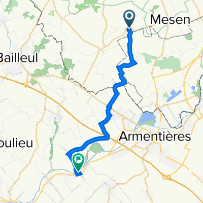
Known for it’s flat finish, Gent-Wevelgem has earned a name for being one of the most gruelling races for sprinters. This signposted route however, doesn't finish in Wevelgem and neither does it start in Gent. The 128km loop starts and finishes at the foot of the legendary Kemmelberg in Heuvelland, Flanders. With it 1.483 altimeters, the route focusses on the area of the West Flemish Hills (Les monts des Flandres in French) along the French-Belgian border. Expect difficult terrain, complete with cobbles, plugstreets, hills and unfavourable winds. Resolute in its history, the Gent-Wevelgem navigates a number of the battlefields from the First World War.
- -:--
- Dauer
- 122,9 km
- Distanz
- 1.428 m
- Aufstieg
- 1.427 m
- Abstieg
- ---
- Ø-Tempo
- ---
- Max. Höhe

Routenqualität
Wegtypen und Untergründe entlang der Route
Wegtypen
Ruhige Straße
90,7 km
(74 %)
Straße
14,5 km
(12 %)
Untergründe
Befestigt
88,1 km
(72 %)
Unbefestigt
0,2 km
(<1 %)
Asphalt
80 km
(65 %)
Beton
7,4 km
(6 %)
Weiter mit Bikemap
Diese Radroute verwenden, bearbeiten oder herunterladen
Du möchtest GENT-WEVELGEM - IN FLANDERS FIELDS 128km fahren oder sie für deine eigene Reise anpassen? Folgendes kannst du mit dieser Bikemap-Route machen:
Gratis Funktionen
- Speichere diese Route als Favorit oder in einer Sammlung
- Kopiere & plane deine eigene Version dieser Route
- Teile sie in Etappen ein, um eine mehrtägige Tour zu erstellen
- Synchronisiere deine Route mit Garmin oder Wahoo
Premium-Funktionen
Kostenlose Testversion für 3 Tage oder einmalige Zahlung. Mehr über Bikemap Premium.
- Navigiere diese Route auf iOS & Android
- Exportiere eine GPX / KML-Datei dieser Route
- Erstelle deinen individuellen Ausdruck (Jetzt kostenlos ausprobieren)
- Lade diese Route für die Offline-Navigation herunter
Entdecke weitere Premium-Funktionen.
Bikemap Premium aktivierenVon unserer Community
Saint-Yvon: Andere beliebte Routen, die hier beginnen
 2022 IEPER - ARRAS Deel 2
- Distanz
- 16 km
- Aufstieg
- 16 m
- Abstieg
- 29 m
- Standort
- Saint-Yvon, Flandern, Belgien
 heuvelland totaal
- Distanz
- 220 km
- Aufstieg
- 1.918 m
- Abstieg
- 1.940 m
- Standort
- Saint-Yvon, Flandern, Belgien
 top whisky - 45.5
- Distanz
- 45,5 km
- Aufstieg
- 479 m
- Abstieg
- 478 m
- Standort
- Saint-Yvon, Flandern, Belgien
 Klokhofweg, Heuvelland naar Kozakstraat, Wevelgem
- Distanz
- 35,6 km
- Aufstieg
- 89 m
- Abstieg
- 195 m
- Standort
- Saint-Yvon, Flandern, Belgien
 West-Vlaamse Bergenroute
- Distanz
- 49,8 km
- Aufstieg
- 391 m
- Abstieg
- 392 m
- Standort
- Saint-Yvon, Flandern, Belgien
 eigen kweek - 49.4
- Distanz
- 49,4 km
- Aufstieg
- 463 m
- Abstieg
- 463 m
- Standort
- Saint-Yvon, Flandern, Belgien
 GENT-WEVELGEM - IN FLANDERS FIELDS 128km
- Distanz
- 122,9 km
- Aufstieg
- 1.428 m
- Abstieg
- 1.427 m
- Standort
- Saint-Yvon, Flandern, Belgien
 westvlaamse bergenroute - 58.7
- Distanz
- 58,7 km
- Aufstieg
- 379 m
- Abstieg
- 379 m
- Standort
- Saint-Yvon, Flandern, Belgien
In der App öffnen