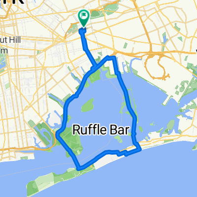
The Tastiest Shirley Chisholm State Park Route
Eine Fahrradroute, die in East New York, New York, USA beginnt.
Übersicht
Über diese Route
Who doesn't love a landfill that has been turned into a delightful oasis for park starved New Yorkers? Something that I truly appreciate about this city is the ingenuity in transforming some of our unused landmasses into a place for all to enjoy, and Shirley Chisholm State Park definitely fits the bill of a great utilization of underused space. This was my first time exploring this former landfill transformed into a state park, and it was a fantastic experience.
- 43 min
- Dauer
- 12,1 km
- Distanz
- 45 m
- Aufstieg
- 56 m
- Abstieg
- 16,8 km/h
- Ø-Tempo
- ---
- Max. Höhe
Fotos von der Route
Routenqualität
Wegtypen und Untergründe entlang der Route
Wegtypen
Ruhige Straße
7,1 km
(58 %)
Radweg
2,1 km
(17 %)
Untergründe
Befestigt
3 km
(25 %)
Asphalt
2,5 km
(21 %)
Beton
0,5 km
(4 %)
Weiter mit Bikemap
Diese Radroute verwenden, bearbeiten oder herunterladen
Du möchtest The Tastiest Shirley Chisholm State Park Route fahren oder sie für deine eigene Reise anpassen? Folgendes kannst du mit dieser Bikemap-Route machen:
Gratis Funktionen
- Speichere diese Route als Favorit oder in einer Sammlung
- Kopiere & plane deine eigene Version dieser Route
- Synchronisiere deine Route mit Garmin oder Wahoo
Premium-Funktionen
Kostenlose Testversion für 3 Tage oder einmalige Zahlung. Mehr über Bikemap Premium.
- Navigiere diese Route auf iOS & Android
- Exportiere eine GPX / KML-Datei dieser Route
- Erstelle deinen individuellen Ausdruck (Jetzt kostenlos ausprobieren)
- Lade diese Route für die Offline-Navigation herunter
Entdecke weitere Premium-Funktionen.
Bikemap Premium aktivierenVon unserer Community
East New York: Andere beliebte Routen, die hier beginnen
 The Tastiest Shirley Chisholm State Park Route
- Distanz
- 12,1 km
- Aufstieg
- 45 m
- Abstieg
- 56 m
- Standort
- East New York, New York, USA
 Restful route in New York
- Distanz
- 15,2 km
- Aufstieg
- 0 m
- Abstieg
- 3 m
- Standort
- East New York, New York, USA
 Loopie
- Distanz
- 40,2 km
- Aufstieg
- 52 m
- Abstieg
- 52 m
- Standort
- East New York, New York, USA
 NYC Century
- Distanz
- 167,9 km
- Aufstieg
- 322 m
- Abstieg
- 321 m
- Standort
- East New York, New York, USA
 Long ride through New York
- Distanz
- 50,9 km
- Aufstieg
- 209 m
- Abstieg
- 208 m
- Standort
- East New York, New York, USA
 12429 Flatlands Ave, New York to 12421 Flatlands Ave, New York
- Distanz
- 14,8 km
- Aufstieg
- 0 m
- Abstieg
- 3 m
- Standort
- East New York, New York, USA
 Day 6: Floyd Bennett Field to Washington Square Park Hotel
- Distanz
- 25,5 km
- Aufstieg
- 147 m
- Abstieg
- 141 m
- Standort
- East New York, New York, USA
 My marathon
- Distanz
- 34,1 km
- Aufstieg
- 19 m
- Abstieg
- 21 m
- Standort
- East New York, New York, USA
In der App öffnen


