

Hadovna-U Dubu-Pod Ondrejovskem-U Obrazku-Lukov (castle)-Bezednik-Vela 23 km (Frystak, Zlin area)
Eine Fahrradroute, die in Fryšták, Zlín, Tschechische Republik beginnt.
Übersicht
Über diese Route
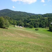
A short but quite demanding trip. I learnt that Beskydy hills are suprisingly demanding compare to Fatra or Nizke Tatry hills/mountains. The terrain and the routes are going up, then down, then up, sort of rollercoaster. The surface is not the most comfortable, definitely it is for MTB (best FS). But here, this route, is sort of OK. Situated north of Zlin city, it is an enter to Beskydy hills to show you what they can offer. It is a shame I do not have GPX of "Solan" area circle route, that was real-real demanding trip (technically as well). Here you can visit some attractions, Lukov castle, there are some nice wells and a small green lake. You can leave your car at Hadovna place, there is a tarmac road uphill and then the show will start :). Definitely you will meet a lot of people, tourists, near wells and especially around Lukov castle so you can have a chit-chat.
- -:--
- Dauer
- 22,9 km
- Distanz
- 822 m
- Aufstieg
- 816 m
- Abstieg
- ---
- Ø-Tempo
- ---
- Max. Höhe

Fotos von der Route
-Bezednik-Vela 23 km (Frystak, Zlin area)\"")
-Bezednik-Vela 23 km (Frystak, Zlin area)\"")
-Bezednik-Vela 23 km (Frystak, Zlin area)\"")
-Bezednik-Vela 23 km (Frystak, Zlin area)\"")
-Bezednik-Vela 23 km (Frystak, Zlin area)\"")
-Bezednik-Vela 23 km (Frystak, Zlin area)\"")
-Bezednik-Vela 23 km (Frystak, Zlin area)\"")
-Bezednik-Vela 23 km (Frystak, Zlin area)\"")
Routenqualität
Wegtypen und Untergründe entlang der Route
Wegtypen
Forst- / Feldweg
20 km
(87 %)
Pfad
2,3 km
(10 %)
Ruhige Straße
0,6 km
(3 %)
Untergründe
Befestigt
7,4 km
(32 %)
Unbefestigt
13,4 km
(59 %)
Natürlicher Untergrund
11 km
(48 %)
Asphalt
4,4 km
(19 %)
Weiter mit Bikemap
Diese Radroute verwenden, bearbeiten oder herunterladen
Du möchtest Hadovna-U Dubu-Pod Ondrejovskem-U Obrazku-Lukov (castle)-Bezednik-Vela 23 km (Frystak, Zlin area) fahren oder sie für deine eigene Reise anpassen? Folgendes kannst du mit dieser Bikemap-Route machen:
Gratis Funktionen
- Speichere diese Route als Favorit oder in einer Sammlung
- Kopiere & plane deine eigene Version dieser Route
- Synchronisiere deine Route mit Garmin oder Wahoo
Premium-Funktionen
Kostenlose Testversion für 3 Tage oder einmalige Zahlung. Mehr über Bikemap Premium.
- Navigiere diese Route auf iOS & Android
- Exportiere eine GPX / KML-Datei dieser Route
- Erstelle deinen individuellen Ausdruck (Jetzt kostenlos ausprobieren)
- Lade diese Route für die Offline-Navigation herunter
Entdecke weitere Premium-Funktionen.
Bikemap Premium aktivierenVon unserer Community
Fryšták: Andere beliebte Routen, die hier beginnen
 Hadovna-U Dubu-Pod Ondrejovskem-U Obrazku-Lukov (castle)-Bezednik-Vela 23 km (Frystak, Zlin area)
- Distanz
- 22,9 km
- Aufstieg
- 822 m
- Abstieg
- 816 m
- Standort
- Fryšták, Zlín, Tschechische Republik
 Frystak-BpH-Drevohostice-Holesov-Zahnasovice-Rackova-
- Distanz
- 67 km
- Aufstieg
- 599 m
- Abstieg
- 600 m
- Standort
- Fryšták, Zlín, Tschechische Republik
 Kostelec - Prusinovice
- Distanz
- 26,2 km
- Aufstieg
- 399 m
- Abstieg
- 399 m
- Standort
- Fryšták, Zlín, Tschechische Republik
 Lukoveček-Holešov-Rusava-Kašava-Lukoveček
- Distanz
- 48,3 km
- Aufstieg
- 636 m
- Abstieg
- 648 m
- Standort
- Fryšták, Zlín, Tschechische Republik
 LOP I:Kostelec-Vizovice-Kostelec
- Distanz
- 40,7 km
- Aufstieg
- 475 m
- Abstieg
- 500 m
- Standort
- Fryšták, Zlín, Tschechische Republik
 Kostelec - Rusava - Koselec
- Distanz
- 29,5 km
- Aufstieg
- 573 m
- Abstieg
- 578 m
- Standort
- Fryšták, Zlín, Tschechische Republik
 zlín - bystřice pod hostýnem
- Distanz
- 38,6 km
- Aufstieg
- 1.128 m
- Abstieg
- 1.072 m
- Standort
- Fryšták, Zlín, Tschechische Republik
 Frystak-Rusava-Chvalcov-Tesak-Trojak-Hostalkova-Lhota u Vsetina-Liptal-Trnava
- Distanz
- 72,6 km
- Aufstieg
- 1.288 m
- Abstieg
- 1.216 m
- Standort
- Fryšták, Zlín, Tschechische Republik
In der App öffnen