

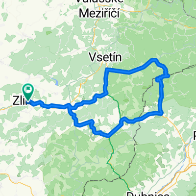
Zlin-Zbozenske rybniky-Rozhledna Hostinec-Hostisova-Sazovice-Hrabuvky-Tlumacov-Zahlinicke rybniky-Kromeriz 30km (Zlin, Kromeriz area)
Eine Fahrradroute, die in Zlín, Zliner Region, Tschechien beginnt.
Übersicht
Über diese Route
This route is for those bikers who are bikers :). Seriously, if you know already the tarmac bike path along Morava and Drevnice rivers from Kromeriz to Zlin (vice versa) and you desire to find a technically more demanding alternative, this is it. The lenght is very similar. The route starts in the centre of Zlin city at yellow line. Then you have to ride above Zlin on a very steep gravel climb, next are Zbozenske ponds in a cottage area. In the middle of a forest, when the non-paved route joins a tarmac one, we have to turn left. Next follows the wooden observation tower Hostinec near Hostisova village. At the highest point of the route there is an airfield with a nice view of area. Follows Sazovice (near is Myslocovice with a cozy bike park), Hrabuvky farmstead with horses, passage under the highway, then Tlumacov village, Zahlinicke ponds and the route ends at railway bridge over Morava river in Kromeriz city. I like this route very much due to it's diverse character. It is rideable in wet conditions as well.
- -:--
- Dauer
- 30,6 km
- Distanz
- 257 m
- Aufstieg
- 292 m
- Abstieg
- ---
- Ø-Tempo
- ---
- Max. Höhe

Fotos von der Route
\"")
\"")
\"")
\"")
\"")
\"")
\"")
\"")
Weiter mit Bikemap
Diese Radroute verwenden, bearbeiten oder herunterladen
Du möchtest Zlin-Zbozenske rybniky-Rozhledna Hostinec-Hostisova-Sazovice-Hrabuvky-Tlumacov-Zahlinicke rybniky-Kromeriz 30km (Zlin, Kromeriz area) fahren oder sie für deine eigene Reise anpassen? Folgendes kannst du mit dieser Bikemap-Route machen:
Gratis Funktionen
- Speichere diese Route als Favorit oder in einer Sammlung
- Kopiere & plane deine eigene Version dieser Route
- Synchronisiere deine Route mit Garmin oder Wahoo
Premium-Funktionen
Kostenlose Testversion für 3 Tage oder einmalige Zahlung. Mehr über Bikemap Premium.
- Navigiere diese Route auf iOS & Android
- Exportiere eine GPX / KML-Datei dieser Route
- Erstelle deinen individuellen Ausdruck (Jetzt kostenlos ausprobieren)
- Lade diese Route für die Offline-Navigation herunter
Entdecke weitere Premium-Funktionen.
Bikemap Premium aktivierenVon unserer Community
Zlín: Andere beliebte Routen, die hier beginnen
 Kaprův okruh - kolem Pinduly
- Distanz
- 17,4 km
- Aufstieg
- 470 m
- Abstieg
- 471 m
- Standort
- Zlín, Zliner Region, Tschechien
 Zlín - Lysá hora
- Distanz
- 111,7 km
- Aufstieg
- 1.970 m
- Abstieg
- 879 m
- Standort
- Zlín, Zliner Region, Tschechien
 Zlín - Portáš
- Distanz
- 129,3 km
- Aufstieg
- 1.272 m
- Abstieg
- 1.272 m
- Standort
- Zlín, Zliner Region, Tschechien
 Zlín- Pindula-Zlín
- Distanz
- 32,7 km
- Aufstieg
- 332 m
- Abstieg
- 336 m
- Standort
- Zlín, Zliner Region, Tschechien
 Okruh - Zlin Lužkovice Zlin
- Distanz
- 21 km
- Aufstieg
- 174 m
- Abstieg
- 173 m
- Standort
- Zlín, Zliner Region, Tschechien
 Kocanda Chlum
- Distanz
- 19,5 km
- Aufstieg
- 292 m
- Abstieg
- 292 m
- Standort
- Zlín, Zliner Region, Tschechien
 _CZE _ Hostýnské vrchy - Zlín - Racková - Rusava - Lukov - Velíková - Zlín
- Distanz
- 49,9 km
- Aufstieg
- 745 m
- Abstieg
- 745 m
- Standort
- Zlín, Zliner Region, Tschechien
 zlin- rackova- horni lapac- hadovna- pod ondrejovskem- frystak- lesna- kostelec -zlin
- Distanz
- 36,3 km
- Aufstieg
- 660 m
- Abstieg
- 660 m
- Standort
- Zlín, Zliner Region, Tschechien
In der App öffnen