

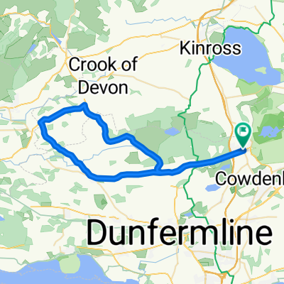
Cleish Hill twice > Gleneagles loop 59
Eine Fahrradroute, die in Kelty, Schottland, Vereinigtes Königreich beginnt.
Übersicht
Über diese Route
Eine schöne Runde mit guten Anstiegen und Abfahrten, die die Grenzen von Kinross und Perthshire erkundet.
- Start am Rand von Kelty – Geschäfte und Cafés in der Nähe. Nach Westen fahren.
- Abbiegen, um den Cleish Hill hinauf- und hinabzufahren – großartige Aussicht über Kinross und Loch Leven zu den Lomond Hills im Osten.
- Flache Straßen nach Kinross, Milnathort, dann nach Osten zum Abzweig Glenfarg (Beinn Inn).
- Dem schmalen Spalt durch die Hügel bei Glenfarg folgen, dann durch Bäume hinabfahren (malerisch und leicht zu fahren) am Beinn Inn vorbei ins flache Tal um Bridge of Earn (Geschäfte hier).
- Weiter auf Nebenstraßen vorbei an Strathallan, Forteviot und Dunning. Alle malerisch – Essensmöglichkeiten in Dunning. Die Nebenstraßen führen weiter in Richtung Gleneagles, um Auchterarder zu umgehen.
- Über Glen Eagles steigen – fühlt sich trickreicher an als der Anstieg auf der Karte zeigt. Schnell durch die Hügel nach Glendevon und die Tore von Muckhart fahren.
- An der Kreuzung links abbiegen und auf relativ flachen Straßen nach Drum, dann Cleish und zurück über den Cleish Hill in die entgegengesetzte Richtung (ziemlich anspruchsvoll).
- Alternative Rückkehr nach Kelty ohne Hügel ist über Blairadam möglich.
- -:--
- Dauer
- 95,8 km
- Distanz
- 649 m
- Aufstieg
- 649 m
- Abstieg
- ---
- Ø-Tempo
- ---
- Max. Höhe
Routenqualität
Wegtypen und Untergründe entlang der Route
Wegtypen
Ruhige Straße
24 km
(25 %)
Straße
6,7 km
(7 %)
Untergründe
Befestigt
51,8 km
(54 %)
Asphalt
50,8 km
(53 %)
Befestigt (undefiniert)
1 km
(1 %)
Undefiniert
44,1 km
(46 %)
Weiter mit Bikemap
Diese Radroute verwenden, bearbeiten oder herunterladen
Du möchtest Cleish Hill twice > Gleneagles loop 59 fahren oder sie für deine eigene Reise anpassen? Folgendes kannst du mit dieser Bikemap-Route machen:
Gratis Funktionen
- Speichere diese Route als Favorit oder in einer Sammlung
- Kopiere & plane deine eigene Version dieser Route
- Teile sie in Etappen ein, um eine mehrtägige Tour zu erstellen
- Synchronisiere deine Route mit Garmin oder Wahoo
Premium-Funktionen
Kostenlose Testversion für 3 Tage oder einmalige Zahlung. Mehr über Bikemap Premium.
- Navigiere diese Route auf iOS & Android
- Exportiere eine GPX / KML-Datei dieser Route
- Erstelle deinen individuellen Ausdruck (Jetzt kostenlos ausprobieren)
- Lade diese Route für die Offline-Navigation herunter
Entdecke weitere Premium-Funktionen.
Bikemap Premium aktivierenVon unserer Community
Kelty: Andere beliebte Routen, die hier beginnen
 Kelty Saline Powmill Knockhill Kelty
- Distanz
- 39,3 km
- Aufstieg
- 408 m
- Abstieg
- 408 m
- Standort
- Kelty, Schottland, Vereinigtes Königreich
 Saturday Morning Kelty-Alva-Kelty
- Distanz
- 69,5 km
- Aufstieg
- 424 m
- Abstieg
- 424 m
- Standort
- Kelty, Schottland, Vereinigtes Königreich
 KCC GP Cleish 10m 2023
- Distanz
- 16 km
- Aufstieg
- 40 m
- Abstieg
- 46 m
- Standort
- Kelty, Schottland, Vereinigtes Königreich
 Stage 7
- Distanz
- 67,8 km
- Aufstieg
- 549 m
- Abstieg
- 442 m
- Standort
- Kelty, Schottland, Vereinigtes Königreich
 GVAP Rawhide Charity Cycle #2
- Distanz
- 50,5 km
- Aufstieg
- 292 m
- Abstieg
- 333 m
- Standort
- Kelty, Schottland, Vereinigtes Königreich
 Cleish Hill twice > Gleneagles loop 59
- Distanz
- 95,8 km
- Aufstieg
- 649 m
- Abstieg
- 649 m
- Standort
- Kelty, Schottland, Vereinigtes Königreich
 Kelty to St Andrews
- Distanz
- 59,7 km
- Aufstieg
- 372 m
- Abstieg
- 481 m
- Standort
- Kelty, Schottland, Vereinigtes Königreich
 Kelty Saline Powmill Cleish Kelty
- Distanz
- 42,4 km
- Aufstieg
- 440 m
- Abstieg
- 440 m
- Standort
- Kelty, Schottland, Vereinigtes Königreich
In der App öffnen