

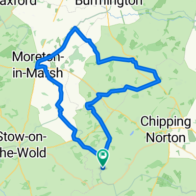
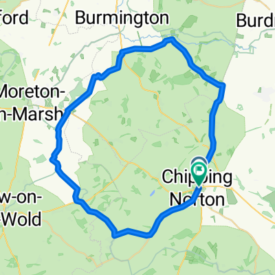
New Way of the Rings Chipping Norton to Marlborough
Eine Fahrradroute, die in Chipping Norton, England, Vereinigtes Königreich beginnt.
Übersicht
Über diese Route
3
Diese 90-Meilen-Strecke (148 km) ist das letzte Segment des 'Way of the Rings', einer 555 km langen Route vom Castlerigg Stone Circle in den Lake District bis nach Stonehenge, die durch oder nahe an neolithischen und historischen Stätten von Interesse vorbeiführt. Sie folgt wahrscheinlich einem Weg, den neolithische Menschen mit ihren Schweinen und Rindern zum Stonehenge für die Wintersonnenwende nahmen.
Diese Tour kann in 1-2 Tagen absolviert werden und führt an folgenden Stätten vorbei:
Rollright Stones (bei Chipping Norton) – Die Rollright Stones sind eine alte Stätte an der Grenze von Oxfordshire und Warwickshire in England. Das Ensemble besteht aus drei Hauptelementen: dem Steinkreis der Kings Men, dem King Stone und den Whispering Knights.
Blenheim Palace – durch die Parkanlagen; Blenheim Palace ist ein Weltkulturerbe mit über 300 Jahren Geschichte und Wohnsitz des 12. Herzogs von Marlborough und seiner Familie. Ein historisches Herrenhaus und Gärten in Oxfordshire.
Uffington White Horse – Der Uffington White Horse ist eine prähistorische Hügelzeichnung von 110 m Länge, gebildet aus tiefen Gräben, die mit zerstoßener weißer Kreide gefüllt sind. Die Figur liegt an den oberen Hängen des White Horse Hill, den die Route passiert.
Stanton Harcourt – Die Devil's Quoits, ein Henge-Monument, wurden während der späten Jungsteinzeit und der Becherkultur genutzt und bestanden aus einem etwa 85 m breiten steinernen Kreis mit 30 oder mehr Steinen; größtenteils im Mittelalter für Ackerbau zerstört, wobei einige Steine möglicherweise im Kirchgebäude von Stanton Harcourt wiederverwendet wurden.
Avebury – Avebury ist ein neolithischer Henge-Monument mit drei Steinkreisen rund um das Dorf Avebury. Eines der bekanntesten prähistorischen Ziele Großbritanniens, es enthält den größten megalithischen Steinkreis der Welt.
Durrington Walls – Durrington Walls ist der Standort einer großen neolithischen Siedlung und späteren Henge-Anlage innerhalb des Stonehenge-Weltkulturerbes, etwa 3,2 km nordöstlich von Stonehenge.
Woodhenge – Woodhenge ist eine eindrucksvolle neolithische Stätte nahe Stonehenge, wahrscheinlich um 2500 v. Chr. erbaut. Ursprünglich hielt man sie für Überreste eines Begräbnisgehöfts, umgeben von einem Wall und Graben, der durch Pflügen fast vollständig zerstört wurde.
Stonehenge – der Start- oder Endpunkt der Route – Stonehenge ist ein prähistorisches Monument etwa 3 km westlich von Amesbury. Es besteht aus einem Kreis von stehenden Steinen, jeder etwa 4 m hoch, 2,1 m breit und rund 25 Tonnen schwer. Die Steine sind in einer Erdworks-Anlage innerhalb des dichtesten Komplexes neolithischer und bronzezeitlicher Monumente in England angeordnet, inklusive hunderter Grabhügel. Archäologen vermuten einen Bauzeitraum von 3000 v. Chr. bis 2000 v. Chr.
Die Route kann von Norden nach Süden oder umgekehrt befahren werden. Es gibt Unterkünfte entlang der Strecke sowie hervorragende Landgasthäuser.
Transport – Bahnhöfe in Salisbury (mit direkter Verbindung nach London) und Pewsey. Es gibt Verkehrsmittel zu Stonehenge und von dort zurück (jedoch nicht fahrradfreundlich), daher müssten die Fahrräder vor Ort abgeschlossen bleiben, während man mit dem Verkehrsmittel zum Bahnhof Salisbury fährt, um z.B. das Auto abzuholen. Bei einer Tour von 1,5-2 Tagen gibt es die Option, mit dem Zug von Oxford nach Salisbury (über Reading und Basingstoke) zu fahren.
- -:--
- Dauer
- 93 km
- Distanz
- 633 m
- Aufstieg
- 704 m
- Abstieg
- ---
- Ø-Tempo
- 227 m
- Max. Höhe
Kathie Knell
Erstellt vor 5 Jahren
Fotos von der Route


Routenqualität
Wegtypen und Untergründe entlang der Route
Wegtypen
Ruhige Straße
31,6 km
34 %
Straße
29,8 km
32 %
Untergründe
Befestigt
57,7 km
(62 %)
Unbefestigt
4,7 km
(5 %)
Asphalt
57,7 km
62 %
Natürlicher Untergrund
3,7 km
4 %
Highlights der Route
POIs entlang der Route

Interessanter Ort nach 1,6 km
Great Rollright - The oldest, the Whispering Knights dolmen, is early Neolithic, circa 3,800-3,500 BC, the King's Men stone circle is late Neolithic, circa 2,500 BC; and the King Stone is early to middle Bronze Age, circa 1,500 BC. The Stones are made of natural boulders of Jurassic oolitic limestone which forms the bulk of the Cotswold hills. This stone has been used extensively in the region for building everything from churches and houses to stone walls. The boulders used to construct the Rollright Stones were probably collected from within 500m of the site. The origins of the name The origin of the name ‘Rollright’ is somewhat uncertain. One interpretation is that it is derived from the Old English ‘Hrolla’+ ‘landriht’, the land-right or property of Hrolla. Old English is the earliest historical form of the English language brought to England by Anglo-Saxon settlers probably in the mid 5th century. Another theory is that it is derived from an even older Celtic language ‘rod’ + ‘land’ + ‘ricc’ meaning the ‘ricc’ (groove, gorge or steep valley) by the ‘rodland’ (wheel arena) – i.e. the stone circle.
Interessanter Ort nach 9,3 km
Hoar Stone at Enstone This was evidently a site of considerable, importance in ancient days if the volume of folklore has anything to go by! Nearly hidden in a small wooded enclosure, between Enstone and Fulwell, where the B4022 meets the Enstone to Ditchley road, we find the ruins of this large chambered tomb. Although today only comprising of three large stones, one of which is almost nine feet tall, when Crawford [1925] visited here there were six stones visible and the remnants stood upon a mound of earth, which is no longer visible. He thought it to be the remains of a dolmen, surrounded by earth, but until substantial excavation work occurs, it is impossible to tell. The present entrance to the site comes from the east.
Interessanter Ort nach 23,3 km
The remains of North Leigh Roman Villa are set within a peaceful landscape on the banks of the river Evenlode in Oxfordshire. This ‘courtyard villa’ is considered to be one of the larger villas of Roman Britain. It was at its most extensive in the early 4th century, when it included three bath suites, 16 mosaic floors and 11 rooms with under-floor heating. Today, two ranges of the former courtyard arrangement of the villa are visible. The most important feature of the site is a fine mosaic tile floor dating to the early 4th century.
Interessanter Ort nach 23,3 km
Well worth visiting the Roman villa - slight deviation from route!
Interessanter Ort nach 37,8 km
Devil's Quoits Fully restored Stone Circle in Oxfordshire. The site is believed to be between 4000 and 5000 years old, and is a Scheduled Ancient Monument. The Quoits were restored between 2002 and 2008, with stones which had been knocked over or had fallen over being re-uprighted, and the surrouding earthworks re-built. Access: Hamish Fenton writes: you can visit pretty much any time you want depending on where you park your vehicle. There are currently no signs saying "This way to the Devils Quoits". Route 1. (c.450 metres from the car). Just outside Stanton Harcourt of the B4449 a "Recycling Centre" is signposted if you follow the signs to it, then continue just past it you will see a small parking area on your left next to the lake (almost opposite a weighbridge), I think this is where you are supposed to park. the parking area is at the southern end of the lake, there is a gravel path with a wire fence on either side leading off around the lake from the corner of the parking area, follow this path and it will take you around the lake to the Devils Quoits, there are some newly planted trees that you will walk past, when the trees on your right finish, turn sharply around the end of the trees and walk up the slope, you should be at the entrance to the Devils Quoits, there is an information board here. note: the road to the recycling centre is gated and will be locked when the recycling centre is shut
Interessanter Ort nach 40,6 km
These ditches were laid out to capture burial mounds in which their own ancestors had buried their dead 1,000 years before the ditch builders." "The ditches connect those ancestral remains with natural elements in the landscape in such a way that they could draw down the sacred power of the rising full moon that occurred only once every 18 years. The rivers were equally important for prehistoric people as living forces running through their landscape." "So the ditches are aligned with the River Windrush where it meets the Thames at Newbridge, cuts across a long loop of the Thames before crossing it and heading over Hurst and Cumnor Hills. It ends up at the point where the River Cherwell meets the Thames on Christchurch Meadows."
Interessanter Ort nach 48,1 km
Hillfort in Oxfordshire From SolarMegalith: Cherbury Camp is located SW from Lovell Court Farm. This multivallate Iron Age fort covers area of 9 acres, the earthworks are in decent condition. In northern part of the hillfort three lines of ramparts and ditches are clearly distinguishable, while on the area enclosed with the ramparts cropmark of a hut circle is visible. The entrance in eastern sector of the hillfort is the original one, the southern was cut in 1930s. Archaeological excavations unearthed Bronze Age arrowheads, Iron Age pottery and coin, as well as Anglo-Saxon brooch. The footpath leading to Cherbury Camp leads through Lovell Court Farm, but it's well disguised - ask the landowner for help, he is a very kind and helpful person.
Interessanter Ort nach 59,8 km
Uffington Castle Neolithic long barrow submitted by h_fenton Uffington Castle Neolithic long barrowA Neolithic long barrow, 25 metres long by up to 12 metres across and 0.3 metres high. The barrow is aligned roughly southwest to northeast about 70 metres north of Uffington Castle. The long barrow also seems to be the focal point of a later Romano-British inhumation cemetery. The barrow was partially excavated in 1857 when a shaft was dug into the middle (you can still see a depression). A cremation in a large coarse urn was found. Later in the Roman period the barrow became the focus of an inhumation cemetery, 46 skeletons were found in 42 graves some of the skulls were found with coins in their mouths which dated them to be late Roman. In June 1993 some geophysical surveys were done and the barrow was partially re-excavated, this revealed that most of the human remains were still in situ although many of the skulls were missing (the skulls may have been removed during the 1857 excavation)
Interessanter Ort nach 60,5 km
Causewayed Enclosure in Oxfordshire Rams Hill Fort. Not actually a fort but a 'causewayed camp' between Uffington Castle and Segsbury Camp on The Ridgeway.
Interessanter Ort nach 60,5 km
Wayland's Smithy This long barrow lies in a plantation of trees on the famous Ridgeway, not far from the Uffington White Horse in Oxfordshire. Footpaths lead to the site from both the Uffington Castle carpark and the B4000 which crosses the Ridgeway around a kilometre away. Excavations in the 1960s revealed the barrow was constructed in two phases - a wooden mortuary enclosure with stone floor was later covered by a trapezoidal mound of chalk. Inside there are three chambers, one main one and two to the sides. The long barrow was reconstructed after excavations - pieces of green plastic trellis can be seen protruding from the mound material near the entrance!
Interessanter Ort nach 62,7 km
Lambourn Long Barrow Lambourn Long BarrowThis long barrow is dated to be one of the earliest in Britain, however little of it remains. The mound is extant, 70m by 18m altough difficult to see its full extent. The barrows is half covered in very tall trees at the end of a small wood. At the western end is a large stone 1m x 1m while at the eastern end is a pile of stones which may have formed some of the barrows structure. Halfway along the southern side is a stone 0.5x x 0.5m. The barrow should be considered in the context of the nineteen round barrows which form the extended Lambourn Barrow Cemetery which are nearby.
Interessanter Ort nach 93 km
Uffington White Horse This beautiful hill carving, lying close to Uffington Hillfort in Oxfordshire is best viewed from a distance but can be accessed by walking uphill from the signposted carpark. The horse is 110m long and carved through the grass into chalk and has been dated to between 1400 and 600BC. (but see comments below for recent dating update) The Uffington White Horse is a highly stylized prehistoric hill figure situated on the upper slopes of White Horse Hill. The figure has been shown to date to the Bronze Age, by means of optically stimulated luminescence dating carried out following archaeological investigations in 1994. These studies produced three dates ranging between 1400 and 600 BC. Iron Age coins that bear a representation comparable to the Uffington White Horse have been found, supporting the early dating of this artifact; counter suggestions that the figure was fashioned in the Anglo-Saxon period now seem untenable. Uffington is by far the oldest of the white horse figures in Britain, and is of an entirely different design from the others. It has long been debated whether the chalk figure was intended to represent a horse or some other animal. The site is owned and managed by the National Trust. Last time we visited, a handy guide book to the monuments in the area could be purchased at the carpark
Interessanter Ort nach 93 km
Durrington Walls is the site of a large Neolithic settlement and later henge enclosure located in the Stonehenge World Heritage Site in England. It lies 2 miles (3.2 km) north-east of Stonehenge in the parish of Durrington, just north of Amesbury in Wiltshire. The henge is the second-largest Late Neolithic palisaded enclosure known in the United Kingdom, after Hindwell in Wales
Interessanter Ort nach 93 km
Woodhenge is an atmospheric Neolithic site close to Stonehenge. Probably built about 2500 BC, it was formed of six concentric ovals of standing posts, surrounded by a bank and ditch. The site was discovered by aerial photography in 1925, when rings of dark spots were spotted in a crop of wheat. Today, concrete markers show the positions of the timber posts
Interessanter Ort nach 93 km
An 'avenue', originally of around 100 pairs of prehistoric standing stones, raised to form a winding 1 1/2 mile ritual link between the pre-existing monuments of Avebury and The Sanctuary. Part of the Avebury World Heritage Site.
Interessanter Ort nach 93 km
Silbury Hill is a prehistoric artificial chalk mound near Avebury in the English county of Wiltshire. It is part of the Stonehenge, Avebury and Associated Sites UNESCO World Heritage Site. At 39.3 metres (129 ft) high, it is the tallest prehistoric man-made mound in Europe and one of the largest in the world; similar in size to some of the smaller Egyptian pyramids of the Giza Necropolis.
Interessanter Ort nach 93 km
West Kennet Long Barrow West Kennet Long Barrow is a Neolithic long barrow dating to 5,650 years ago. With its large facade and long chalk barrow it is a striking monument, you can also go into the tomb and explore the chambers within. West Kennet Long Barrow was built 5,650 years ago and was used for around 1,000 years.
Interessanter Ort nach 93 km
Stonehenge is perhaps the world’s most famous prehistoric monument. It was built in several stages: the first monument was an early henge monument, built about 5,000 years ago, and the unique stone circle was erected in the late Neolithic period about 2500 BC. In the early Bronze Age many burial mounds were built nearby. Today, together with Avebury, Stonehenge forms the heart of a World Heritage Site, with a unique concentration of prehistoric monuments.
Interessanter Ort nach 93 km
The Barge Inn Great Canal side pub!
Trinkwasser nach 93 km
Honey street Cafe - great value and excellent service!
Interessanter Ort nach 93 km
Avebury Avebury is part of an extraordinary set of Neolithic and Bronze Age ceremonial sites that seemingly formed a vast sacred landscape. They include West Kennet Avenue, West Kennet Long Barrow, The Sanctuary, Windmill Hill, and the mysterious Silbury Hill. Many can be reached on foot from the village.
Weiter mit Bikemap
Diese Radroute verwenden, bearbeiten oder herunterladen
Du möchtest New Way of the Rings Chipping Norton to Marlborough fahren oder sie für deine eigene Reise anpassen? Folgendes kannst du mit dieser Bikemap-Route machen:
Gratis Funktionen
- Speichere diese Route als Favorit oder in einer Sammlung
- Kopiere & plane deine eigene Version dieser Route
- Teile sie in Etappen ein, um eine mehrtägige Tour zu erstellen
- Synchronisiere deine Route mit Garmin oder Wahoo
Premium-Funktionen
Kostenlose Testversion für 3 Tage oder einmalige Zahlung. Mehr über Bikemap Premium.
- Navigiere diese Route auf iOS & Android
- Exportiere eine GPX / KML-Datei dieser Route
- Erstelle deinen individuellen Ausdruck (Jetzt kostenlos ausprobieren)
- Lade diese Route für die Offline-Navigation herunter
Entdecke weitere Premium-Funktionen.
Bikemap Premium aktivierenVon unserer Community
Chipping Norton: Andere beliebte Routen, die hier beginnen
- New Way of the Rings Chipping Norton to Marlborough3
- 93 km
- 633 m
- 704 m
- Chipping Norton, England, Vereinigtes Königreich


In der App öffnen