

12th Ave NE, Minneapolis to 12th Ave NE, Minneapolis
- 9,2 km
- 25 m
- 36 m
- Lauderdale, Minnesota, Vereinigte Staaten
Eine Fahrradroute, die in Lauderdale, Minnesota, Vereinigte Staaten beginnt.
Übersicht
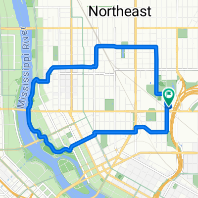
Take Malcolm north to the U of MN Transitway.
Take a left onto the U of MN Transitway. Note: you can bike in the road - the only thing you will see are buses. Or you can take the bike/ped trail but you should watch your speed as there are walkers.
Continue on the U of MN Transitway until you reach Oak. Continue past Oak, and the Transitway will spit you out onto 5th St.
5th St. will have a bike lane.
Take 5th St all the way to 10th Ave, cross 10th Ave and you will see a spiral bike/ped bridge over 35 W.
Take the bridge over 35 W and continue on 5th St until you reach 6th Ave.
Take a left onto 6th Ave and follow that down the hill to the Stone Arch Bridge.
Take the Stone Arch Bridge (bike/ped) over the river.
Once on the other side of the river, take a left onto Portland.
Take Portland to 2nd St.
Take a right onto 2nd St. which has a lovely bike lane.
Continue on 2nd St. to Marquette.
At this point, you can take a right, then a left and then a left to get to the other side of the block. What I have mapped simply involves carrying your bike up 3 steps to cut through the block so you can continue on 2nd St.
The last few blocks to the destination are a little hairy no matter what route you take (it's not a very bikable area) but I recommend crossing Hennepin here, going on 2nd St to 1st Ave N.
Take a left on 1st Ave N and continue to your destination.
Erstellt vor 17 Jahren
Weiter mit Bikemap
Du möchtest B2B00844 55414 > 55401 via U of MN Transitway, 5th St, Stone Arch Bridge, 2nd St fahren oder sie für deine eigene Reise anpassen? Folgendes kannst du mit dieser Bikemap-Route machen:
Kostenlose Testversion für 3 Tage oder einmalige Zahlung. Mehr über Bikemap Premium.
Entdecke weitere Premium-Funktionen.
Bikemap Premium aktivierenVon unserer Community
In der App öffnen


