

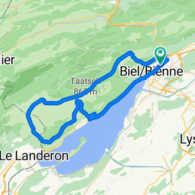
P-Biel/Twann/Lignieres/Enges/Nods/Twannberg/Macolin/Evilard (60km)
Eine Fahrradroute, die in Biel, Kanton Bern, Schweiz beginnt.
Übersicht
Über diese Route
Wonderful route (all paved). 5 km to warm-up then there is short steep road to go up; this route is forbidden to cars, with lovely view of lake and wineyards (better don't do saturday/sunday afternoon because there are many people walking the way). At km 8 starts climb to Twannberg (4km quite steep). Next real climb is at km 27, when you sudden turn to right (direction Enges): this is really nice climb in the forest, 1km long and more than 10% (you need good legs). At the end of forest, turn right again into cantonal road where climb continues at 7-8%. Next climb starts at km 34 (La Combe du Sapin) till km 36. Then long downhill and again turn right to Twannberg (km 44) and it starts lovely and funny part of the road, it's up&down along a narrow road, forbidden to cars. At the end of the climb you need to pass a gate, carrying your bike for few meters. Then fast downhill back to Biel/Bienne.
- -:--
- Dauer
- 60,1 km
- Distanz
- 1.143 m
- Aufstieg
- 1.141 m
- Abstieg
- ---
- Ø-Tempo
- ---
- Max. Höhe

Routenqualität
Wegtypen und Untergründe entlang der Route
Wegtypen
Straße
33,1 km
(55 %)
Ruhige Straße
16,2 km
(27 %)
Untergründe
Befestigt
36,1 km
(60 %)
Unbefestigt
0,6 km
(1 %)
Asphalt
30,7 km
(51 %)
Befestigt (undefiniert)
5,4 km
(9 %)
Highlights der Route
POIs entlang der Route
Interessanter Ort nach 17,7 km
DANGER !!! difficult turn on the right
Trinkwasser nach 30,1 km
Trinkwasser nach 38,3 km
Trinkwasser nach 53,6 km
Weiter mit Bikemap
Diese Radroute verwenden, bearbeiten oder herunterladen
Du möchtest P-Biel/Twann/Lignieres/Enges/Nods/Twannberg/Macolin/Evilard (60km) fahren oder sie für deine eigene Reise anpassen? Folgendes kannst du mit dieser Bikemap-Route machen:
Gratis Funktionen
- Speichere diese Route als Favorit oder in einer Sammlung
- Kopiere & plane deine eigene Version dieser Route
- Synchronisiere deine Route mit Garmin oder Wahoo
Premium-Funktionen
Kostenlose Testversion für 3 Tage oder einmalige Zahlung. Mehr über Bikemap Premium.
- Navigiere diese Route auf iOS & Android
- Exportiere eine GPX / KML-Datei dieser Route
- Erstelle deinen individuellen Ausdruck (Jetzt kostenlos ausprobieren)
- Lade diese Route für die Offline-Navigation herunter
Entdecke weitere Premium-Funktionen.
Bikemap Premium aktivierenVon unserer Community
Biel: Andere beliebte Routen, die hier beginnen
 P-Biel/Bienne TRACK2 (16km)
- Distanz
- 15,5 km
- Aufstieg
- 242 m
- Abstieg
- 244 m
- Standort
- Biel, Kanton Bern, Schweiz
 P-GRAVEL-Biel-Hagneck-Aarberg-Lyss-Orpund (41 km)
- Distanz
- 41,1 km
- Aufstieg
- 217 m
- Abstieg
- 214 m
- Standort
- Biel, Kanton Bern, Schweiz
 P-BielerSee (65km)
- Distanz
- 65 km
- Aufstieg
- 850 m
- Abstieg
- 851 m
- Standort
- Biel, Kanton Bern, Schweiz
 P-Biel/Twann/Lignières/Nods/Orvin/Evilard (47 km)
- Distanz
- 47,4 km
- Aufstieg
- 802 m
- Abstieg
- 802 m
- Standort
- Biel, Kanton Bern, Schweiz
 Theo's
- Distanz
- 25,3 km
- Aufstieg
- 838 m
- Abstieg
- 832 m
- Standort
- Biel, Kanton Bern, Schweiz
 Zum Chasseral-Gletscher
- Distanz
- 57,2 km
- Aufstieg
- 1.285 m
- Abstieg
- 1.329 m
- Standort
- Biel, Kanton Bern, Schweiz
 P-BielerSee (85km)
- Distanz
- 84,7 km
- Aufstieg
- 736 m
- Abstieg
- 734 m
- Standort
- Biel, Kanton Bern, Schweiz
 P-BielerSee (62km)
- Distanz
- 61,5 km
- Aufstieg
- 1.003 m
- Abstieg
- 1.002 m
- Standort
- Biel, Kanton Bern, Schweiz
In der App öffnen