

B2B00870 55116>55343 via MississippiRvBlvd/LakeStBridge/W.RiverRd/Greenway/Blake/Excel
Eine Fahrradroute, die in Mendota Heights, Minnesota, Vereinigte Staaten beginnt.
Übersicht
Über diese Route
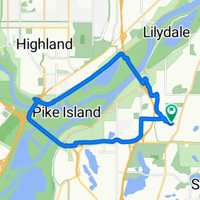
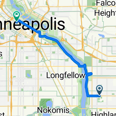
Take Hartford to Mississippi River Blvd. Turn right and continue to the Marshall/Lake St. Bridge. Cross over to Minneapolis and turn right to West River Road. Continue north on West River Road to 27th Avenue (just before the bridge) and the ramp to the Greenway Bike Trail. At 28th Street you can either cross Hiawatha Avenue with the stop light or go north and take the new Martin Sabo bridge over Hiawatha. Take the Greenway west until you reach Blake Road. Turn left to Excelsior Blvd. Turn left on Excelsior Blvd to Interlachen Road. Turn right to your destination.
- -:--
- Dauer
- 21,2 km
- Distanz
- 114 m
- Aufstieg
- 96 m
- Abstieg
- ---
- Ø-Tempo
- ---
- Max. Höhe
Highlights der Route
POIs entlang der Route
Interessanter Ort nach 7,4 km
At this point you can either cross Hiawatha directly or take the Martin Sabo bridge to the north.
Weiter mit Bikemap
Diese Radroute verwenden, bearbeiten oder herunterladen
Du möchtest B2B00870 55116>55343 via MississippiRvBlvd/LakeStBridge/W.RiverRd/Greenway/Blake/Excel fahren oder sie für deine eigene Reise anpassen? Folgendes kannst du mit dieser Bikemap-Route machen:
Gratis Funktionen
- Speichere diese Route als Favorit oder in einer Sammlung
- Kopiere & plane deine eigene Version dieser Route
- Synchronisiere deine Route mit Garmin oder Wahoo
Premium-Funktionen
Kostenlose Testversion für 3 Tage oder einmalige Zahlung. Mehr über Bikemap Premium.
- Navigiere diese Route auf iOS & Android
- Exportiere eine GPX / KML-Datei dieser Route
- Erstelle deinen individuellen Ausdruck (Jetzt kostenlos ausprobieren)
- Lade diese Route für die Offline-Navigation herunter
Entdecke weitere Premium-Funktionen.
Bikemap Premium aktivierenVon unserer Community
Mendota Heights: Andere beliebte Routen, die hier beginnen
 South Minnehaha Drive 4935-4925, Minneapolis to South Minnehaha Drive, Minneapolis
- Distanz
- 39,9 km
- Aufstieg
- 10 m
- Abstieg
- 3 m
- Standort
- Mendota Heights, Minnesota, Vereinigte Staaten
 Mendota Heights-South St.Paul
- Distanz
- 35,7 km
- Aufstieg
- 218 m
- Abstieg
- 218 m
- Standort
- Mendota Heights, Minnesota, Vereinigte Staaten
 Snail-like route in Mendota Heights
- Distanz
- 14 km
- Aufstieg
- 325 m
- Abstieg
- 325 m
- Standort
- Mendota Heights, Minnesota, Vereinigte Staaten
 B2B00870 55116>55343 via MississippiRvBlvd/LakeStBridge/W.RiverRd/Greenway/Blake/Excel
- Distanz
- 21,2 km
- Aufstieg
- 114 m
- Abstieg
- 96 m
- Standort
- Mendota Heights, Minnesota, Vereinigte Staaten
 Mendota to Calhoun
- Distanz
- 22 km
- Aufstieg
- 171 m
- Abstieg
- 132 m
- Standort
- Mendota Heights, Minnesota, Vereinigte Staaten
 Fort Snelling Loop
- Distanz
- 33,8 km
- Aufstieg
- 162 m
- Abstieg
- 164 m
- Standort
- Mendota Heights, Minnesota, Vereinigte Staaten
 B2B 55116 > 55106 via Summit Ave, Kellogg Blvd E
- Distanz
- 14,3 km
- Aufstieg
- 40 m
- Abstieg
- 63 m
- Standort
- Mendota Heights, Minnesota, Vereinigte Staaten
 B2B00191 55115>55401viaRandolph/MissBlvd/LkStBridge/WRiverPkwy/WashAv
- Distanz
- 11,6 km
- Aufstieg
- 97 m
- Abstieg
- 109 m
- Standort
- Mendota Heights, Minnesota, Vereinigte Staaten
In der App öffnen