
Route des antiquaires CLONED FROM ROUTE 102532
Eine Fahrradroute, die in Daveluyville, Quebec, Canada beginnt.
Übersicht
Über diese Route
<span style="font-family: Arial;">
<span style="font-size: small;"><span style="font-family: Arial;"><font color="#000000">
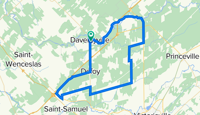
<span style="font-size: 12pt; font-family: Arial; mso-fareast-font-family: 'Times New Roman'; mso-ansi-language: FR-CA; mso-fareast-language: FR-CA; mso-bidi-language: AR-SA;"><span style="font-family: Arial;">Roulez sur les routes reliant Victoriaville, Saint-Valère, Daveluyville, Saint-Louis-de-Blandford et Saint-Rosaire. C’est une plaine paisible et agréable située à la porte des Bois-Francs et parsemée d’antiquaires</span></span>
<span style="font-family: Arial;"> </span>
<span style="font-family: Arial;">Départ : Stationnement du Club Sportif de Daveluyville, 1, 9<sup>e</sup> avenue, Daveluyville. </span>
<span style="font-family: Arial;"> </span>
<span style="font-family: Arial;">DIRECTIONS</span>
<span style="font-family: Arial;"> </span>
<span style="font-family: Arial;">Prendre la direction <span style="mso-bidi-font-weight: bold;">nord</span> sur la <span style="mso-bidi-font-weight: bold;">rue Principale</span> vers Maddington et traversez le pont. <span style="mso-bidi-font-weight: bold;"> 1,7 km </span></span>
<span style="font-family: Arial; mso-bidi-font-weight: bold;"> </span>
<span style="font-family: Arial;">Tournez à <span style="mso-bidi-font-weight: bold;">droite</span> sur <span style="mso-bidi-font-weight: bold;">le Rang de la Rivière et roulez jusqu'au Rang Smith de Saint-Louis-de-Blandford. 9,7 km </span></span>
<span style="font-family: Arial; mso-bidi-font-weight: bold;"> </span>
<span style="font-family: Arial;">Traversez le viaduc et roulez jusqu'au village de Saint-Louis-de-Blandford.<span style="mso-bidi-font-weight: bold;"> 4,9 km </span></span>
<span style="font-family: Arial; mso-bidi-font-weight: bold;"> </span>
<span style="font-family: Arial;">Tournez à droite sur la rue Principale et traversez le village. 1,1 km</span>
</font></span></span>
<span style="font-family: Arial;">Empruntez à gauche la Route 162 jusqu'au 4 ième Rang de Saint-Rosaire. 5,6 km</span>
<span style="font-family: Arial;">Attention: utilisez les accotements routiers.</span>
<span style="font-family: Arial;">Tournez à gauche sur le Rang 4. 3,3 km</span>
<span style="font-family: Arial;">Empruntez à votre gauche La Route de l'Église et roulez jusqu'au village. 3 km</span>
<span style="font-family: Arial;">À l'intersection de la rue Principale, tournez à droite et empruntez le Chemin de la Coupe. 0,5 km</span>
<span style="font-family: Arial;">Du Chemin de la Coupe roulez jusqu'au Rang 8. 4,9 km</span>
<span style="font-family: Arial;">À l'intersection tournez à droite sur le Rang 8. 9,4 km</span>
<span style="font-family: Arial;">À la Route 261, tournez à droite jusqu'au Rang des Chênes. 1,7 km</span>
<span style="font-family: Arial;">Tournez à gauche sur le Rang des Chênes jusqu'à la Route des Bouleaux. 6,6 km</span>
<span style="font-family: Arial;">Empruntez à gauche la Route des Bouleaux et ensuite prenez la Route 161 jusqu'au Rang des Cèdres. 2,8 km</span>
<span style="font-family: Arial;">Tournez à droite sur le Rang des Cèdres. 4 km</span>
<span style="font-family: Arial;">Empruntez à droite le Rang des Épinettes juqu'à la route 261. 4 km</span>
<span style="font-family: Arial;">Prenez à gauche sur la route 261 en direction de Daveluyville. 6,5 km</span>
<span style="font-family: Arial;">Attention : circulation automobile rapide.</span>
</span>
Arrivée au Centre Sportif de Daveluyville.
- -:--
- Dauer
- 70,7 km
- Distanz
- 100 m
- Aufstieg
- 97 m
- Abstieg
- ---
- Ø-Tempo
- ---
- Ø-Tempo

Routenqualität
Wegtypen und Untergründe entlang der Route
Wegtypen
Straße
47,9 km
(68 %)
Vielbefahrene Straße
9,5 km
(13 %)
Untergründe
Befestigt
9,8 km
(14 %)
Unbefestigt
1,6 km
(2 %)
Asphalt
6,8 km
(10 %)
Befestigt (undefiniert)
3 km
(4 %)
Weiter mit Bikemap
Diese Radroute verwenden, bearbeiten oder herunterladen
Du möchtest Route des antiquaires CLONED FROM ROUTE 102532 fahren oder sie für deine eigene Reise anpassen? Folgendes kannst du mit dieser Bikemap-Route machen:
Gratis Funktionen
- Speichere diese Route als Favorit oder in einer Sammlung
- Kopiere & plane deine eigene Version dieser Route
- Synchronisiere deine Route mit Garmin oder Wahoo
Premium-Funktionen
Kostenlose Testversion für 3 Tage oder einmalige Zahlung. Mehr über Bikemap Premium.
- Navigiere diese Route auf iOS & Android
- Exportiere eine GPX / KML-Datei dieser Route
- Erstelle deinen individuellen Ausdruck (Jetzt kostenlos ausprobieren)
- Lade diese Route für die Offline-Navigation herunter
Entdecke weitere Premium-Funktionen.
Bikemap Premium aktivierenVon unserer Community
Daveluyville: Andere beliebte Routen, die hier beginnen
 Cyclo Bois Francs sortie exterieur
- Distanz
- 81,8 km
- Aufstieg
- 127 m
- Abstieg
- 127 m
- Standort
- Daveluyville, Quebec, Kanada
 Daveluyville Cycling
- Distanz
- 13,9 km
- Aufstieg
- 40 m
- Abstieg
- 54 m
- Standort
- Daveluyville, Quebec, Kanada
 Petit dimanche
- Distanz
- 28,6 km
- Aufstieg
- 45 m
- Abstieg
- 44 m
- Standort
- Daveluyville, Quebec, Kanada
 St-Rosaire/Québec
- Distanz
- 119,3 km
- Aufstieg
- 143 m
- Abstieg
- 224 m
- Standort
- Daveluyville, Quebec, Kanada
 Daveluyville - Rivière Bécancour
- Distanz
- 110,6 km
- Aufstieg
- 175 m
- Abstieg
- 175 m
- Standort
- Daveluyville, Quebec, Kanada
 Les campagnes de Daveluyville
- Distanz
- 53,1 km
- Aufstieg
- 80 m
- Abstieg
- 82 m
- Standort
- Daveluyville, Quebec, Kanada
 1150 Rue Ste-Thérèse, St-Wenceslas à 1150 Rue Ste-Thérèse, St-Wenceslas
- Distanz
- 51,1 km
- Aufstieg
- 140 m
- Abstieg
- 136 m
- Standort
- Daveluyville, Quebec, Kanada
 Tournée de la Canneberge
- Distanz
- 50,8 km
- Aufstieg
- 80 m
- Abstieg
- 80 m
- Standort
- Daveluyville, Quebec, Kanada
In der App öffnen