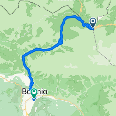
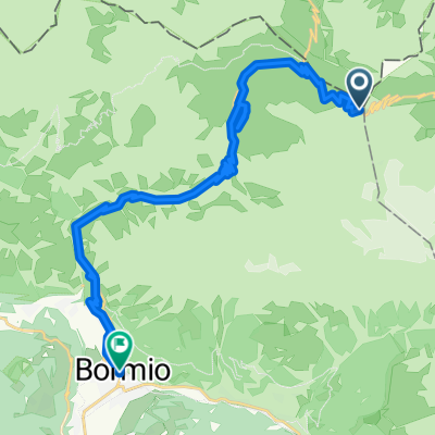
Santa Caterina - Passo del Gavia
Eine Fahrradroute, die in Sant'Antonio, Lombardy, Italy beginnt.
Übersicht
Über diese Route
The Gavia Pass, between the provinces of Sondrio and Brescia, is one of the highest and even most beautiful passes of the Alps. The uphill in this case starts in Santa Caterina Valfurva (the other side stardts from Ponte di Legno -BS-). On top of the Gavia Pass you find the pittoresque lake "Lago Bianco", surrounded by the mountain "Corno dei Tre Signori", 3359 m. Even more beautiful is the lake "Lago Nero" on 2386 m, which is situated just underneath the pass on the south side. The Gavia Pass is opened from June to September.
The side facing the Valtellina is less steep than the other one, even if it is a longer way up to the pass.<br /> The road is mostly constantly uphill, with some short but very steep stretches. Starting in Bormio, take the road SS 300 which leads through the Valfurva: you pass by its little villages Uzza, San Nicolò, S.Antonio und San Gottardo and will arrive, after 13 km and 600 metres in altitude, to Santa Caterina (little map). After Santa Caterina the "real" road up to the Gaviapass begins with its first switchback. From here on, the gradient is most of the time at about over 7 %, it reaches, however, quite often the 10 % mark for short stretches. The tight road brings you constantly higher in altitude.- -:--
- Dauer
- 13,3 km
- Distanz
- 970 m
- Aufstieg
- 87 m
- Abstieg
- ---
- Ø-Tempo
- ---
- Ø-Tempo
Routenqualität
Wegtypen und Untergründe entlang der Route
Wegtypen
Undefiniert
13,3 km
(100 %)
Untergründe
Undefiniert
13,3 km
(100 %)
Weiter mit Bikemap
Diese Radroute verwenden, bearbeiten oder herunterladen
Du möchtest Santa Caterina - Passo del Gavia fahren oder sie für deine eigene Reise anpassen? Folgendes kannst du mit dieser Bikemap-Route machen:
Gratis Funktionen
- Speichere diese Route als Favorit oder in einer Sammlung
- Kopiere & plane deine eigene Version dieser Route
- Synchronisiere deine Route mit Garmin oder Wahoo
Premium-Funktionen
Kostenlose Testversion für 3 Tage oder einmalige Zahlung. Mehr über Bikemap Premium.
- Navigiere diese Route auf iOS & Android
- Exportiere eine GPX / KML-Datei dieser Route
- Erstelle deinen individuellen Ausdruck (Jetzt kostenlos ausprobieren)
- Lade diese Route für die Offline-Navigation herunter
Entdecke weitere Premium-Funktionen.
Bikemap Premium aktivierenVon unserer Community
Sant'Antonio: Andere beliebte Routen, die hier beginnen
- September in Italy
- Distanz
- 1.050,7 km
- Aufstieg
- 3.955 m
- Abstieg
- 6.358 m
- Standort
- Sant'Antonio, Lombardei, Italien
- Gavia Pass Runde
- Distanz
- 138,6 km
- Aufstieg
- 3.211 m
- Abstieg
- 3.211 m
- Standort
- Sant'Antonio, Lombardei, Italien
- Santa Caterina - Passo del Gavia
- Distanz
- 13,3 km
- Aufstieg
- 970 m
- Abstieg
- 87 m
- Standort
- Sant'Antonio, Lombardei, Italien
- CF3J+MW, Valfurva do Strada Statale 300, Valfurva
- Distanz
- 27 km
- Aufstieg
- 4.739 m
- Abstieg
- 5.195 m
- Standort
- Sant'Antonio, Lombardei, Italien
- Route zu Armon Greenblu Hotel & Wellness
- Distanz
- 111,7 km
- Aufstieg
- 4.766 m
- Abstieg
- 5.245 m
- Standort
- Sant'Antonio, Lombardei, Italien
- Santa Caterina - Bormio - Passo dello Stelvio & zurück
- Distanz
- 67,6 km
- Aufstieg
- 2.120 m
- Abstieg
- 2.120 m
- Standort
- Sant'Antonio, Lombardei, Italien
- Santa Caterina-Passo Gavia-Passo Mortirolo-Santa Caterina
- Distanz
- 107,2 km
- Aufstieg
- 2.942 m
- Abstieg
- 2.942 m
- Standort
- Sant'Antonio, Lombardei, Italien
- 2.Etapa - BRM-P.Stelvio-Umbrailpass-Prato allo Stelvio-P.Stelvio-BRM
- Distanz
- 114,4 km
- Aufstieg
- 3.403 m
- Abstieg
- 3.404 m
- Standort
- Sant'Antonio, Lombardei, Italien