Harney – Sam's Creek
Eine Fahrradroute, die in Taneytown, Maryland, USA beginnt.
Übersicht
Über diese Route
<span style="mso-bidi-font-family: "DejaVu Sans Condensed";">Harney is a small town (actually, just a few houses on a four corner intersection) that is about 20 minutes south of </span><span style="mso-bidi-font-family: "DejaVu Sans Condensed";">Gettysburg</span><span style="mso-bidi-font-family: "DejaVu Sans Condensed";"> on Highway 134 (which runs right by the Travel lodge in </span><span style="mso-bidi-font-family: "DejaVu Sans Condensed";">Gettysburg</span><span style="mso-bidi-font-family: "DejaVu Sans Condensed";">!). </span><span style="mso-bidi-font-family: "DejaVu Sans Condensed";"></span>
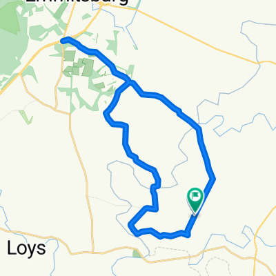
<span style="mso-bidi-font-family: "DejaVu Sans Condensed";">This </span><span style="mso-bidi-font-family: "DejaVu Sans Condensed";">Maryland</span><span style="mso-bidi-font-family: "DejaVu Sans Condensed";"> remote start gets you right into the best </span><span style="mso-bidi-font-family: "DejaVu Sans Condensed";">Maryland</span><span style="mso-bidi-font-family: "DejaVu Sans Condensed";"> has to offer in rolling hills and interesting winding roads following Buffalo Creek and Sam's Creek. </span><span style="mso-bidi-font-family: "DejaVu Sans Condensed";"></span>
<span style="mso-bidi-font-family: "DejaVu Sans Condensed";">You have lots of options to shorten or extend these two basic loops. In fact, the 70Km Loop is simply the top half of the 102Km loop with a bee-line to </span><span style="mso-bidi-font-family: "DejaVu Sans Condensed";">Union</span><span style="mso-bidi-font-family: "DejaVu Sans Condensed";"> </span><span style="mso-bidi-font-family: "DejaVu Sans Condensed";">Bridge</span><span style="mso-bidi-font-family: "DejaVu Sans Condensed";"> for an early lunch!</span><span style="mso-bidi-font-family: "DejaVu Sans Condensed";"></span> <span style="font-size: 12.0pt; font-family: "Times New Roman"; mso-fareast-font-family: "Times New Roman"; mso-bidi-font-family: "DejaVu Sans Condensed"; mso-ansi-language: EN-US; mso-fareast-language: EN-US;">Note the caution on the steel grate bridge on </span><span style="font-size: 12.0pt; font-family: "Times New Roman"; mso-fareast-font-family: "Times New Roman"; mso-bidi-font-family: "DejaVu Sans Condensed"; mso-ansi-language: EN-US; mso-fareast-language: EN-US;">Harney Road West</span><span style="font-size: 12.0pt; font-family: "Times New Roman"; mso-fareast-font-family: "Times New Roman"; mso-bidi-font-family: "DejaVu Sans Condensed"; mso-ansi-language: EN-US; mso-fareast-language: EN-US;"> of Harney in the cue sheets! We don't take that road because this is a very dangerous bridge for cyclists coming down a steep hill trying to make a hard right turn on the bridge! If you are making up your own route, make a note of that!</span>
- -:--
- Dauer
- 104 km
- Distanz
- 497 m
- Aufstieg
- 497 m
- Abstieg
- ---
- Ø-Tempo
- ---
- Max. Höhe
Routenqualität
Wegtypen und Untergründe entlang der Route
Wegtypen
Straße
67,2 km
(65 %)
Ruhige Straße
29,8 km
(29 %)
Untergründe
Befestigt
49,8 km
(48 %)
Unbefestigt
3,2 km
(3 %)
Asphalt
49,6 km
(48 %)
Unbefestigt (undefiniert)
3,2 km
(3 %)
Weiter mit Bikemap
Diese Radroute verwenden, bearbeiten oder herunterladen
Du möchtest Harney – Sam's Creek fahren oder sie für deine eigene Reise anpassen? Folgendes kannst du mit dieser Bikemap-Route machen:
Gratis Funktionen
- Speichere diese Route als Favorit oder in einer Sammlung
- Kopiere & plane deine eigene Version dieser Route
- Teile sie in Etappen ein, um eine mehrtägige Tour zu erstellen
- Synchronisiere deine Route mit Garmin oder Wahoo
Premium-Funktionen
Kostenlose Testversion für 3 Tage oder einmalige Zahlung. Mehr über Bikemap Premium.
- Navigiere diese Route auf iOS & Android
- Exportiere eine GPX / KML-Datei dieser Route
- Erstelle deinen individuellen Ausdruck (Jetzt kostenlos ausprobieren)
- Lade diese Route für die Offline-Navigation herunter
Entdecke weitere Premium-Funktionen.
Bikemap Premium aktivierenVon unserer Community
Taneytown: Andere beliebte Routen, die hier beginnen
 225 Savannah Dr, Gettysburg to 225 Savannah Dr, Gettysburg
- Distanz
- 6,3 km
- Aufstieg
- 4 m
- Abstieg
- 6 m
- Standort
- Taneytown, Maryland, USA
 Harney – Sam's Creek
- Distanz
- 104 km
- Aufstieg
- 497 m
- Abstieg
- 497 m
- Standort
- Taneytown, Maryland, USA
 1611 S Keysville Rd, Keymar to 1700–1704 S Keysville Rd, Keymar
- Distanz
- 27,5 km
- Aufstieg
- 278 m
- Abstieg
- 278 m
- Standort
- Taneytown, Maryland, USA
 Carroll Vista to Butterburg Inn
- Distanz
- 26,4 km
- Aufstieg
- 1.722 m
- Abstieg
- 1.736 m
- Standort
- Taneytown, Maryland, USA
 Francis Scott Key Highway 1610, Keymar to Francis Scott Key Highway 3481, Taneytown
- Distanz
- 8,4 km
- Aufstieg
- 69 m
- Abstieg
- 58 m
- Standort
- Taneytown, Maryland, USA
 Francis Scott Key Highway 1610, Keymar to Uniontown Road 2818, Westminster
- Distanz
- 28,8 km
- Aufstieg
- 365 m
- Abstieg
- 331 m
- Standort
- Taneytown, Maryland, USA
 Harney Union Bridge
- Distanz
- 68,5 km
- Aufstieg
- 372 m
- Abstieg
- 372 m
- Standort
- Taneytown, Maryland, USA
 1611 S Keysville Rd, Keymar to 3907 Old Taneytown Rd, Taneytown
- Distanz
- 17,3 km
- Aufstieg
- 202 m
- Abstieg
- 216 m
- Standort
- Taneytown, Maryland, USA
In der App öffnen

