Radroute in Useldange, Distrikt Diekirch, Luxemburg
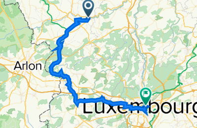
[DAY 6] Useldange - Luxembourg City

Route in der Bikemap App öffnen

Diese Route in Bikemap Web öffnen
Distanz
Aufstieg
Abstieg
Dauer
ø-Tempo
Max. Höhe
Radroute in Useldange, Distrikt Diekirch, Luxemburg
Route in der Bikemap App öffnen
Diese Route in Bikemap Web öffnen
This is the worst cycling experience so far. It started fine until I reached Steinfort. Then, the path began to get confucing as signs are frequently missing at the presence of divergent roads. IT SHOULD BE NOTED, the cycling experience worsens visibly after approaching the verge of the city center (around 5-8km away). At Cimetière de Merl, two paths are available yet only one of them has sign on it leading you to the south of the city instead of the center. I chose the wrong path here and wasted almost 1 hour going back and forth. My advice would be to constantly check with your GPS.
The route on the city center is misleading as well due to a large amount of traffic and a funny road design. I was lost in the labyrinth of narrow historical streets (though, this part I don't complain).
On top of that, the city is built partly on a UNESCO site, and thus has a extremly hilly layout. Sometimes, you'd have to ascend 20m+ abruptly to get through from one neighborhood to another, making it particularly challenging and sometimes dangerous (the roads are narrow without seperated cycling path) for innercity cycling.
Wusstest du schon? Du kannst diese Route als Vorlage in unserem Routenplaner verwenden, und sie ganz einfach nach deinen Bedürfnissen anpassen. So planst du noch schneller deine perfekte Radtour.
In der App öffnen